The State of the Atmosphere: Sunday, December 23, 2018

Well, it's been quite a week tracking the coming week's weather-maker. Let's first take a quick step back, then see how things are looking for this week.
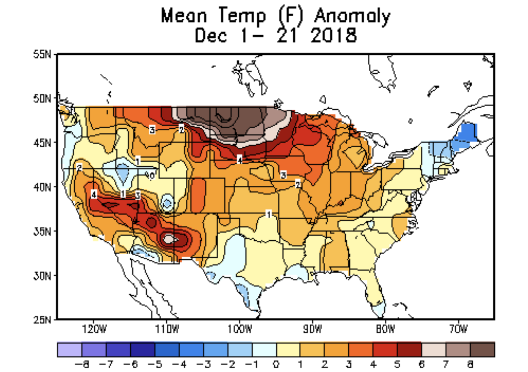
It's bee a warm month nationally. This, despite a cold start to the month for much of the country. Once more our analog package looks like it'll do very well this month overall.
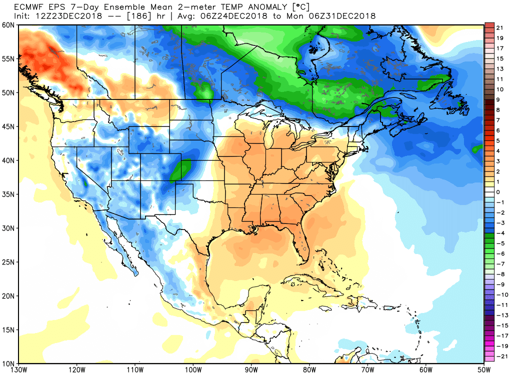
The last week of the year looks to be colder across the west as several troughs are set to bring an active finish to the month for much of the country. This too has been well advertised to our Insiders (I've beaten the 2014 connection to death), but the details surrounding the last week of the month remain... well... elusive.
Regarding the upcoming week...
What we do know is the week is likely to start relatively mild and dry across the region. MOS guidance has highs in the upper 40s for Denver on Monday, and mid 40s on Tuesday ahead of our approaching system.
By Tuesday night we start to track changes across the state. Here's where things start to fall apart.
The evolution of this forecast has been fascinating, if frustrating, to watch. Over recent days we've seen most (all?) models go from a rather potent snow storm for the urban corridor Tuesday night into Thursday (yes, less so from their ensembles), to largely missing us entirely last night, to slowing the system and trying to recover things a bit today.
It all comes down to perhaps minor details in the exact track and speed of the low as it moves across the region Tuesday night through Thursday. Models at one point were trying to track a Four Corner's low across the CO/NM state line Tuesday into Wednesday providing a very favorable setup for snow along the Front Range. Last night nearly all guidance tracked the main low WAY too far south and east for much impact at all around here. Today we've seen them adjust north and west a bit, but not really enough perhaps for the Denver area.
Overall, the storm looks slower than it did a few days ago. It's forecast to come onshore Monday and dive VERY far south as it moves inland Monday/Tuesday, then eventually will try to track into western Kansas late Wednesday into Thursday. If this happens, this'll be our best window for snow around here. If it ends getting too far east before strengthening... then we'll likely lack the upslope we need to see much of any snow around here.
So, if you're trying to keep hope alive for a big snow in Denver, well, don't read the following as our gambler charts really take the wind out of the sails here:
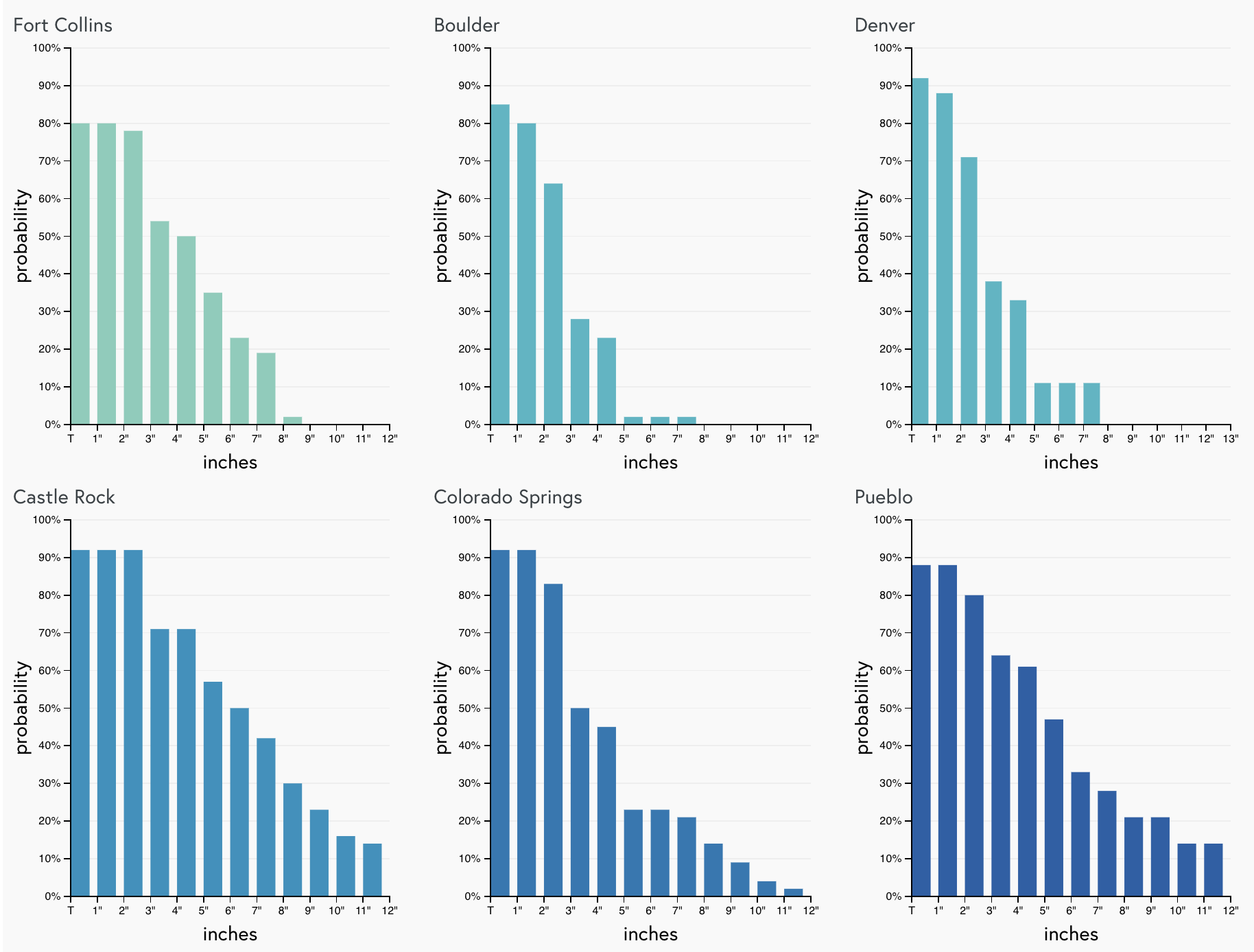
As you can see, Boulder and Denver are a really not looking good for big snow, but it's not exactly a zero chance either. Castle Rock could do a bit better with a more southeasterly storm track as models indicate some northerly winds for a time Wednesday that could promote some snow. COS and Pueblo show some high end potential with the current track, but I think these odds may be a bit overdone given how things have trended in the last day or so.
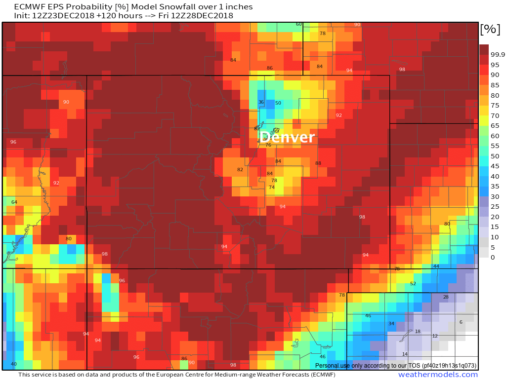
The EURO ensemble mean is in good agreement with these gamblers overall. The current probability of seeing 1" of snow through Friday is pretty good across most of the state –– the exception to that being areas north of Denver:
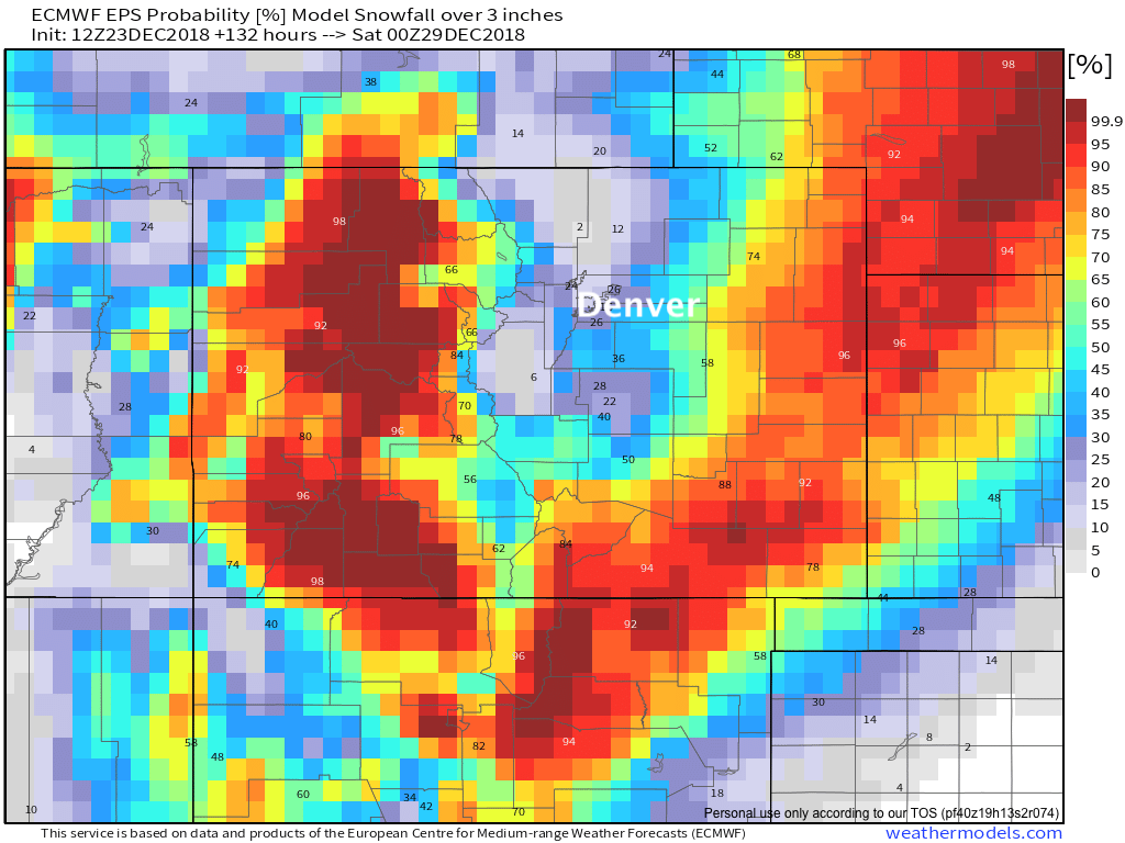
When we bump that up to 3" of snow or more... the bottom really falls out around here. Best odds in the Denver area are to the south across the Palmer, but really you have to head east/southeast to see probabilities back over 50% across the plains:
tl;dr
The long and the short of it is...
- Expect a mild and quiet start to the week before changes arrive late Tuesday or perhaps not until Wednesday.
- We'll be watching the Wednesday/Thursday timeframe closely over the next few days. Right now guidance indicates heaviest snow will end up east of the urban corridor, with likely some tough travel conditions across the eastern plains Wednesday night and Thursday.
- We fully expect changes to occur to guidance over the next couple of days... and with that, expect to hear a wide range of forecasts for midweek as we start the week. Right now model ensembles show a very low probability of a high impact snow event for the northern urban corridor. Could that change? Absolutely. It won't take a huge shift in the storm track to change things in a hurry around here.
- The current ensemble mean snowfall forecast from the EURO looks pretty good barring any changes to the storm track in coming days. Note pretty light totals for Denver - Fort Collins, with heavy snow across the far eastern plains:
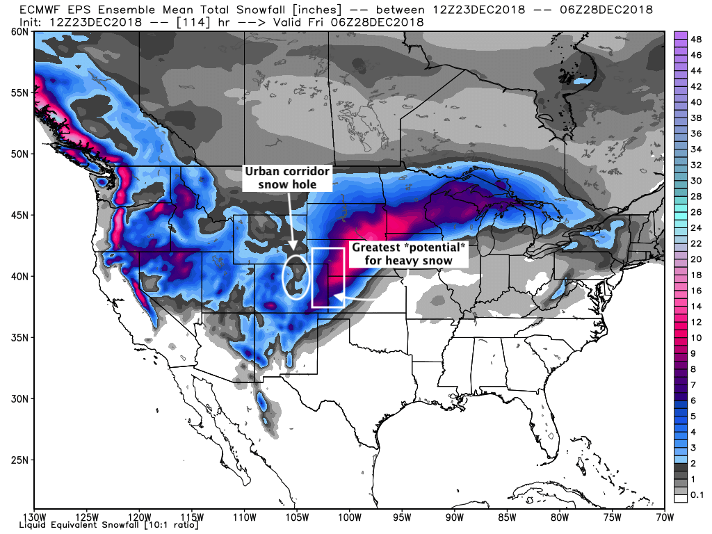
It's not hard to imagine how different that map might look if the storm deviates from where we expect to to track right now. A little further west, a little stronger, and we're back in the game along the Front Range. Do your snow dances people!
If this system misses... perhaps a trailing system next week will deliver a bit of snow instead. Right now that one looks to remain quite far south, but should keep us chilly and unsettled as we head toward the New Year.