Denver Has Yet to See Any Measurable Snow in December, That May Change on Monday

Our next blast of arctic air, and perhaps our best chance of snow this month (that's not saying much!) is set to arrive Sunday evening and stick with us into the New Year. If we can't manage accumulating snow Monday, it'll be the first time since 2002 (a top analog year of ours) that Denver will end December without any measurable snowfall.
Highs Sunday will be mild across northeast Colorado, with GFS MOS showing highs near 50 for Denver before the front arrives late in the day. MOS guidance then has highs in Denver in the teens for Monday and only near 20 on Tuesday before a warming trend returns midweek.
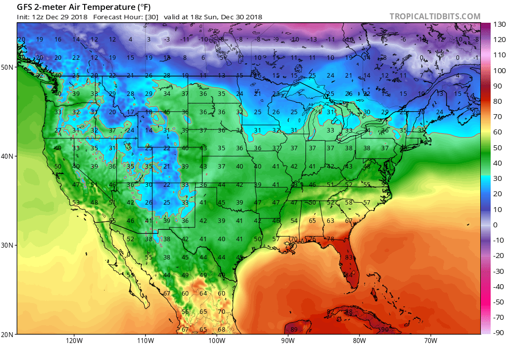
Tomorrow we do not see a lot of cold airs across the country:
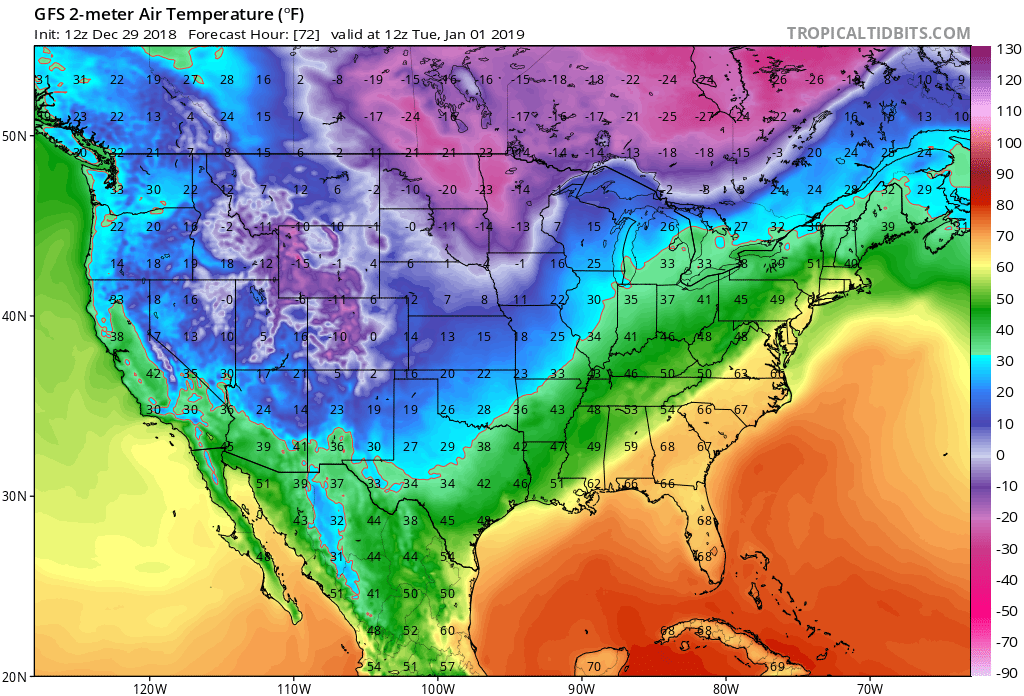
But this arctic blast will change that in a hurry across the region region Monday and Tuesday with 2-meter GFS temperatures for early Tuesday morning depicted below (near 0°F for a low in Denver is likely):
As for snow... well, the models got a bit excited this morning, but given their track record, let's hold off on getting too excited just yet. Models do show some good moisture with this system, but as is often the case with these arctic fronts, there's a good chance they are overdone. Eight times out of 10 when we see models ramp up QPF a day or two prior to an arctic event, the bottom drop out as we move within 24 hours of first flake. We aren't in the 24 hour window yet, so let's see what happens tonight/tomorrow morning.
If you are hoping for accumulating snow, however, it does appear as though you've got pretty good odds at seeing at some, especially if you live in the greater Denver area, across the Palmer Divide, and in the Front Range mountains. Areas north toward Wyoming won't have as ideal a setup, as the northerly winds forecast with this event often mean downsloping off the Cheyenne Ridge.
As we discussed with our Insiders a few days ago, this system certainly has better ensemble support for some accumulating snow, even if light totals for most areas. The GFS remains more bullish than the EURO (not a great sign for snow lovers), but even the EURO has held steady in its means with about 0.1" to 0.25" QPF across the greater Denver area. (The GFS is showing some 0.5"+ totals across the southwest foothills and Palmer Divide today, which for the moment seem overdone –– but lookout!).
And finally, our snowfall gambler charts are showing pretty decent odds for Denver to see >3" of snow from Sunday night through Monday night, so I'm not willing to totally sleep on this system just yet. Our gamblers have done remarkably well this year... but I do wonder if QPF is being overdone and if we'll see them correct tomorrow closer to the EURO. Something to watch.
Timing and impacts
Wintry weather will roll into northern Colorado early Sunday, eventually spreading south/southeast Sunday evening. COLD AIR and occasional flurries/snow showers will be with well into Tuesday.
At the moment, it looks like Denver's snow chances hold off until later Sunday evening (perhaps after 9pm), unless the front moves in quicker which is often the case.
Most models show a mostly northerly wind with this system, which if true would favor the Palmer Divide and likely limit snow from Denver north. The GFS is a bit more northeasterly, perhaps partly why it has the heavier totals. In either event, look for the best chance for accumulating snow in Denver to come between midnight Sunday night and early afternoon Monday. Snow showers/flurries that linger into Monday night will be less impactful for most areas, though could pad totals in a few spots.
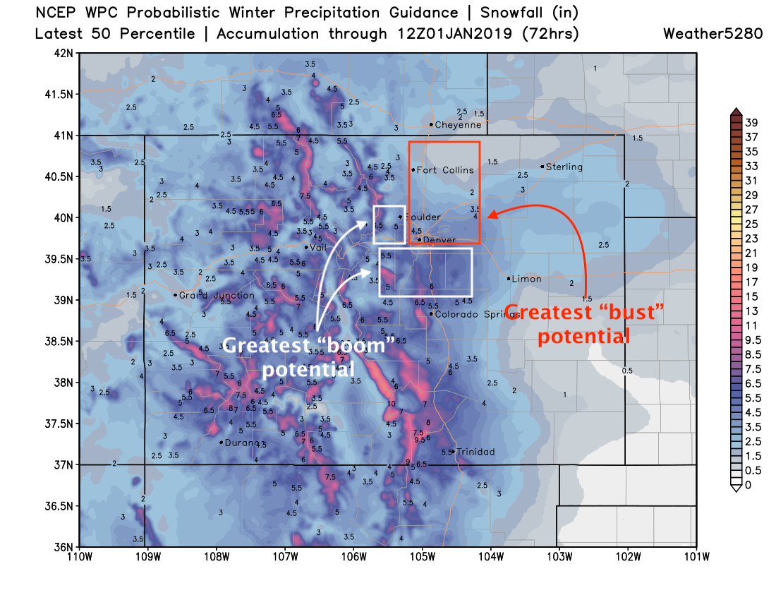
Again, I think the GFS (others too such as the SREF) may be overdone, especially as the EURO remains consistently lower. With that, I think this map below is also likely overdone. That said, for areas like Boulder County and the western Palmer Divide, I wouldn't sleep on this system just yet. Denver, north along I-25... a bigger "bust" potential here if winds remain primarily northerly rather than north/northeast. A northerly wind would also limit snowfall in Colorado Springs proper, with most of the good accumulation ending up north of the city. Details we'll work out tomorrow.
Generally speaking, something like the following is what we're thinking as of this afternoon:
Fort Collins: 0 - 2"
Thornton: 0 - 3"
Denver (downtown): 1 - 4" (boom scenario 2 - 6")
Denver (south): 2 - 5" (boom scenario 3 - 6")
Boulder: 2 - 5" (boom scenario 4 - 8")
Castle Rock: 3 - 6" (boom scenario 4 - 8")
Colorado Springs: Trace - 4" (highest north)
We'll likely see these numbers change a bit tomorrow.
Important to note: Even if snow totals end up not impressing with this system, it's very likely to be COLD. With New Year's Eve on Monday night please plan accordingly. Temperatures Monday afternoon will likely be in the teens across the region, with lows dropping into the single digits and perhaps below freezing. Wind chills will be much lower than this. The NWS currently has a low of 1°F forecast for Denver Monday night, and there's a chance that's not cold enough. If you are headed out to celebrate please dress warmly!
Let's see what data does this evening. Will we see models drop QPF tonight? Or will they wait to heartbreak until tomorrow? I suspect most models will move toward the EURO and not the other way around. I do wonder if the one place the EURO is too low is to Denver's south and southwest, but time will tell.
Another update to follow on Sunday.