The State of the Atmosphere: Sunday, March 10, 2019, "Will It Storm?" Edition

Monday update: Winter Storm Watch posted
We are continuing to track a potent storm system set to bring heavy rain, wind, snow, and blizzard conditions to portions of eastern Colorado and the High Plains by midweek.
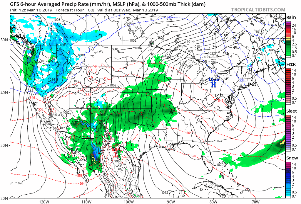
In many ways, a remarkably consistent 24 hours in the modeling since your update yesterday. The same models that were bringing heavy snow to Northeast Colorado yesterday continue to do so today. The models that continue to track the low too far east for Northeast Colorado to see much of anything also continue their respective trend.
Overall we continue to lean toward a western, more impactful storm track for much of eastern Colorado, which both the GFS and Euro models and their ensembles support. Between Tuesday and Thursday morning we are going to see some wild weather across the eastern plains –– from heavy rain (likely some thunder!), to heavy snow, to wind-driven snow that will produce blizzard conditions at times.
We now spend the next couple of days zeroing in on the details. What's abundantly clear is that just a matter of miles difference in storm track will equate to huge differences in outcomes –– especially for those of us living along the Front Range foothills and I-25 urban corridor.
What we know
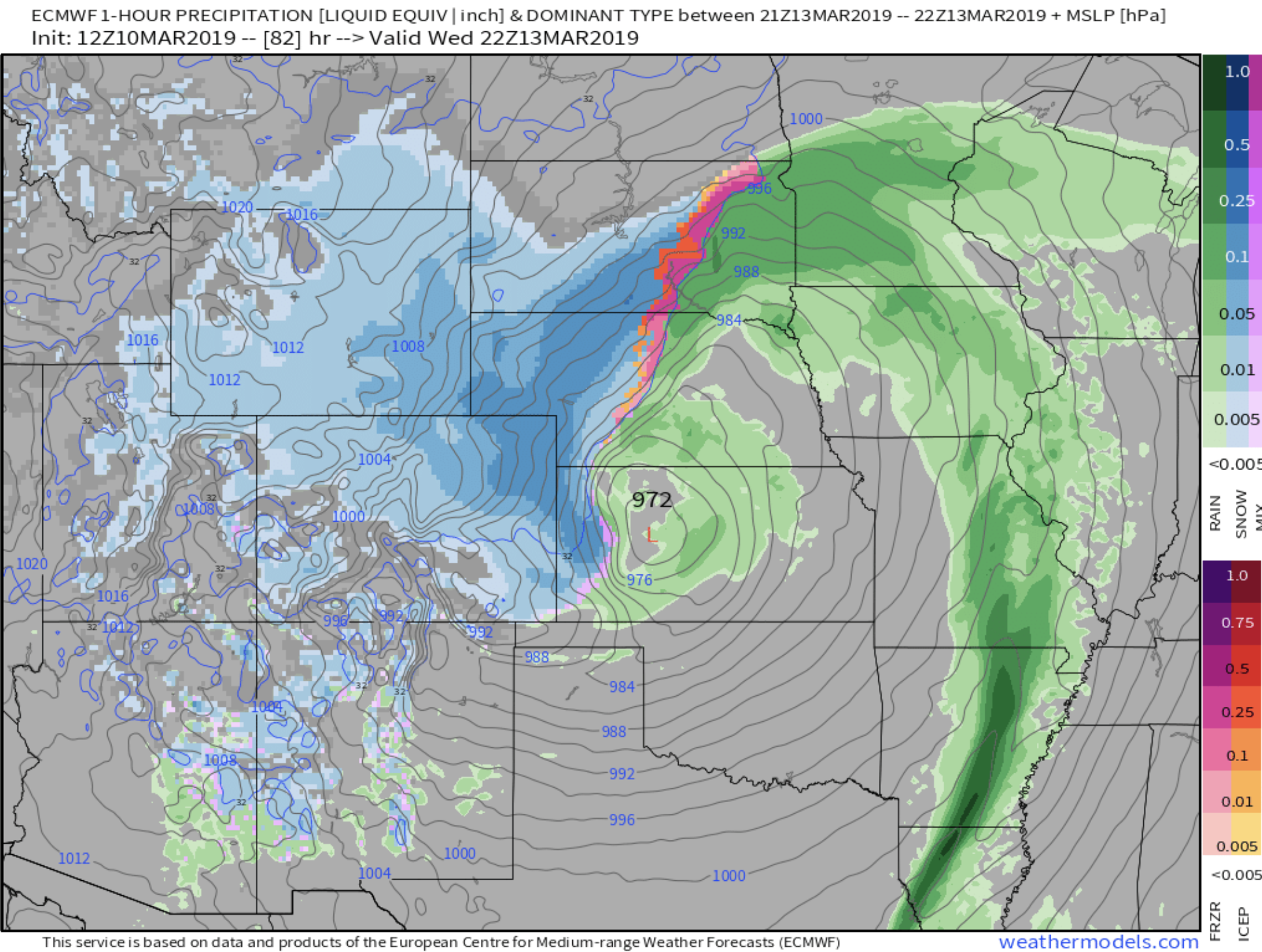
We know this is going to be a heck of a storm for someone. Whether it lines up just right for the urban corridor or not is the question. The latest Euro has a 972mb low over western Kansas Wednesday which is about as low a pressure you'll ever see forecast for this region, and indicates a very strong storm:
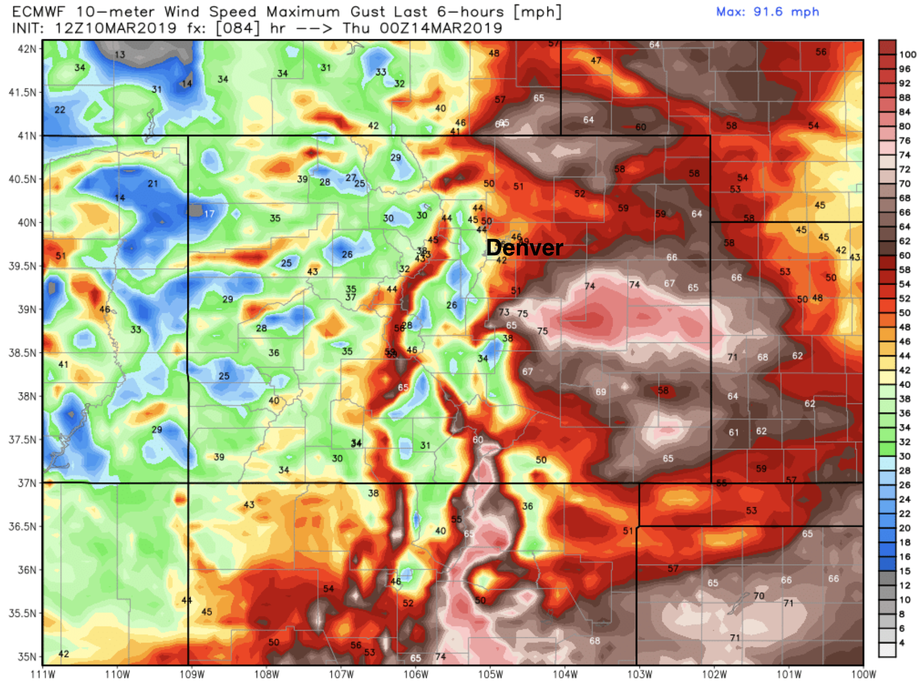
We also know that it's going to be a VERY windy system, especially as you get just east of I-25 and out across most of eastern Colorado. The latest forecast from the European model for Wednesday evening shows gusts to 80mph across the plains –– which snow or no snow is going to cause problems. Denver in this particular model looks windy (gusts to 50mph), but the worst of the wind likely sets up just east and south of the city. The Palmer Divide is likely to get smacked:
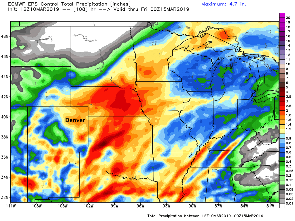
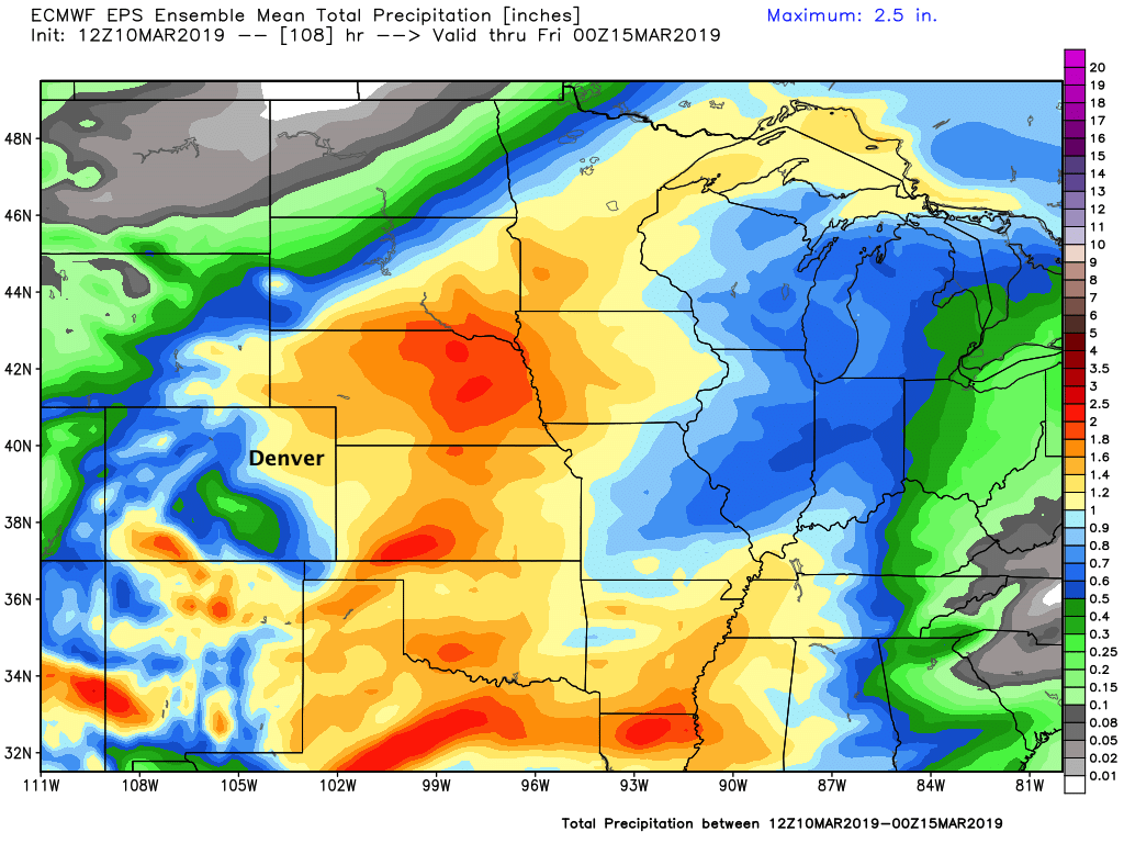
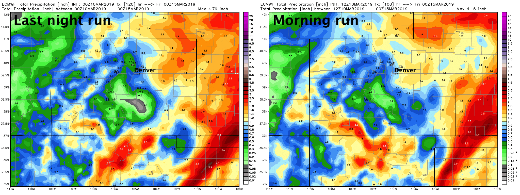
We know it'll be a wet system, tapping plenty of moisture from the Gulf and throwing it up around the low into eastern Colorado and the surrounding states. The latest European control (bottom top) and its ensemble mean (bottom bottom) show much of Northeast Colorado forecast to get a good inch or more of moisture by Thursday afternoon, as well as plenty of moisture for Texas, Oklahoma, Kansas, and Nebraska:
We also know the details will likely continue to change right up until the system is on top of us Wednesday. So, please stay tuned.
Closer to home
Yesterday we looked at this system at more of a macro level. Today, let's consider a few things closer to home.
The way I see it is there are really two things we need to watch that will mean the difference between Denver seeing 2" of slush or a significant March snow. Temperature and storm track. And really, wherever this thing tracks it'll be snowing so hard on Wednesday that we're not all that concerned about temperatures not cooling enough to support accumulation/snow... which really brings us back to eventual track.
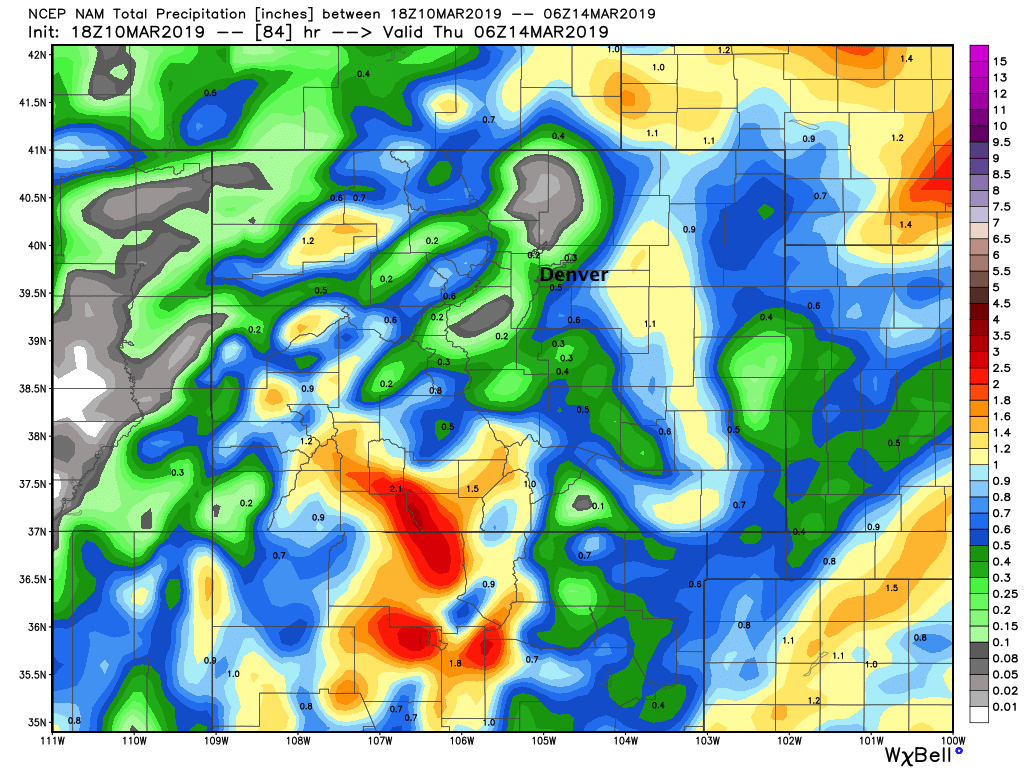
If you live on Denver's north side, and up into Boulder, Loveland, Fort Collins... I would say your 'bust' potential is pretty high at this point. Many models continue to show downsloping winds shutting off snowfall pretty quickly Wednesday for these areas –– even as they favor areas south and east of I-70/I-76. Today's NAM for example? Rather sobering. Almost no QPF (precipitation) forecast for areas north and west of Denver, but 0.5" to 1"+ from Denver southeast across the Palmer Divide. This is absolutely a possibility(!!!) as we all know the winds giveth and the winds taketh our snow around here.
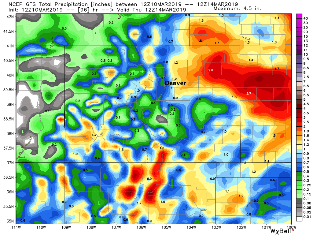
Now, the latest GFS shows slightly more favorable winds for more of us along the northern urban corridor Wednesday (still pretty northerly) and with that better-looking coverage of rain and snow across the region.
Of course, again, the difference of a few miles is likely to be big with this system. In this particular model we see 1.2" of liquid forecast for DIA, with 0.5" on Denver's west side:
And even with the Euro we see subtle differences run to run, despite it being very consistent overall. Last night showing just 0.3" liquid for the Boulder area, today with slightly better upslope upwards of 0.8" for the same area. As you can see overall not a huge difference between the maps, but locally would be the difference of a storm and a non-storm for Boulder. On the Northeast Plains, upwards of 1.0" in both scenarios:
So, in effort not to beat a dead horse... yes there's a big storm coming, yes it could deliver heavy snow to the Denver area, but no, the blizzard of the century for the city is not looking like a lock. For Denver, Boulder, Loveland, Fort Collins and the surrounding areas we aren't likely to feel very confident on snow totals for awhile yet. For Castle Rock, Elizabeth, Limon, and the rest of east-central Colorado we have greater confidence in higher snowfall totals, AND perhaps more importantly strong winds blowing that snow sideways. In many areas you won't be able to measure how much snow you received, so the exact inch forecast does not matter all that much.
TODO
Wait. That's all we can do. The storm is in the ballpark. Models are holding pretty steady. The potential for heavy snow is there (as is the potential for little to none!), so let's just see how things look tomorrow.
Could Denver see 10" (more?) from this system? Absolutely. Could we end up with a slushy inch and a lot of empty milk and bread store shelves for nothing? Yes. It's just way too early to say, and anyone that tells you otherwise isn't being straight with you. I suspect the mostly likely total lies somewhere in between (our gamblers do too) –– but I quite frankly could still see it going either way. Again, east and southeast of Denver we have greater confidence in seeing those greater snow accumulations.
As for planning... we expect Monday and Tuesday to be mostly mild and pretty quiet for the greater metro area. Changes arrive Tuesday night, with the bulk of the storm moving through Wednesday, and exiting far eastern Colorado Thursday. As it looks today, the commute most likely to be impacted from this storm in Denver is Wednesday PM, though Wednesday morning could be a mess too depending on eventual speed and track.
Lots more data to come... if you have questions please ask below, otherwise we'll check back tomorrow.