The State of the Atmosphere, September 1st, 2019

The story this Labor Day weekend is hurricane Dorian as it slams the Northern Bahamas Sunday as a catastrophic category 5 hurricane. The storm will slow to a crawl through Monday before turning north and tracking off the Southeastern United States through week's end. Dorian is now one of the strongest hurricanes on record for the Western Atlantic, with this from National Hurricane Center discussion earlier today:
Air Force and NOAA reconnaissance planes penetrated the distinct
eye of Dorian, and found that the hurricane has become extremely
intense with a stadium effect in the eye. The NOAA plane reported a
peak flight-level wind of 159 kt, while the SFMR from both planes
have measured winds between 155 and 170 kt. A dropsonde from the
NOAA plane measured a wind gust of 176 kt at the surface. A blend of
these measurements yield to an initial intensity of 155 kt, making
Dorian the strongest hurricane on record in the northwestern
Bahamas.
And later:
With this landfall statement, #Dorian's winds are estimated at an astounding 185 mph. Only 4 storms on record (since 1851) in the Atlantic have estimated winds of 185 mph or higher:
— Michael Lowry (@MichaelRLowry) September 1, 2019
Allen (1980) - 190 mph
Wilma (2005) - 185 mph
Gilbert (1988) - 185 mph
1935 Labor Day - 185 mph pic.twitter.com/ZERv4cwbTx
Below is the latest forecast track from the NHC. This will continue to change at least slightly with each update, so for those wanting the latest on the storm or with loved ones in the area -- continue to track the latest at www.nhc.noaa.gov.
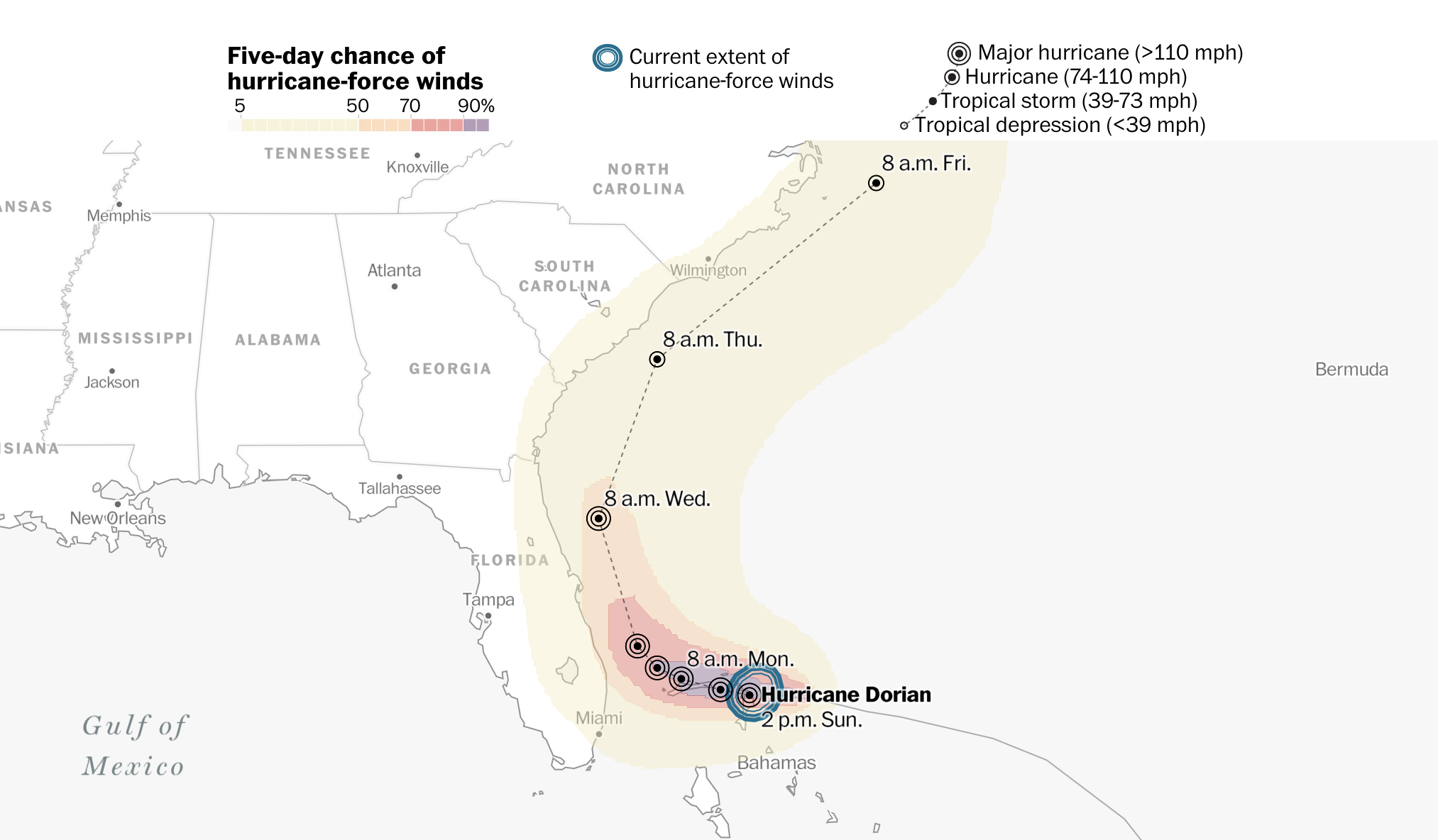
While currently there is no direct landfall forecast for the mainland United States, coastal residents from Florida through the Carolinas will need to remain on alert through the week. Hurricane Warnings are in effect for east-central Florida tonight, and we will likely see additional warnings on the way Monday for those who will be impacted by this storm. A slight wobble in track of just several miles could mean the difference between hurricane conditions and flooding rain or a whole lot of not much as the storm tracks off the Southeast coast. And, most importantly, a landfall is not out of the question just yet -- Florida, Georgia, and the Carolinas are still within the realm of possibility for a landfall if the current forecast track should shift slightly in the coming days.
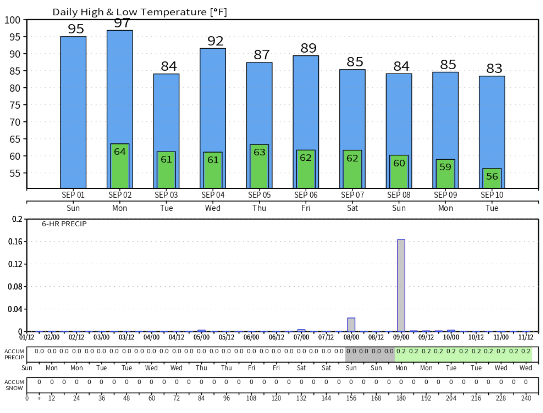
Close to home, the big weather story is the heat. The unofficial average temperature for the month was 75.4°F in Denver, tying it for third (same as 2007) for warmest Augusts on record for the city. Today, Denver set a record high for the date of 98°F, beating out the old record of 97°F set back in 1995. As highs climb back into the upper 90s tomorrow it's clear that September will pick up right where August left off: hot.
MOS guidance has Denver topping out in the upper 90s again on Monday (99°F from the NAM) which would break the previous record for September (95°F 1983) by several degrees.
Relief from the heat comes Tuesday has highs drop back into the mid 80s for the metro area, with a slightly better chance of storms as well.
Overall a pretty uneventful week is forecast for Eastern Colorado. Heat to start, then mid 80s to perhaps low 90s on Thursday with only isolated storm chances most days.
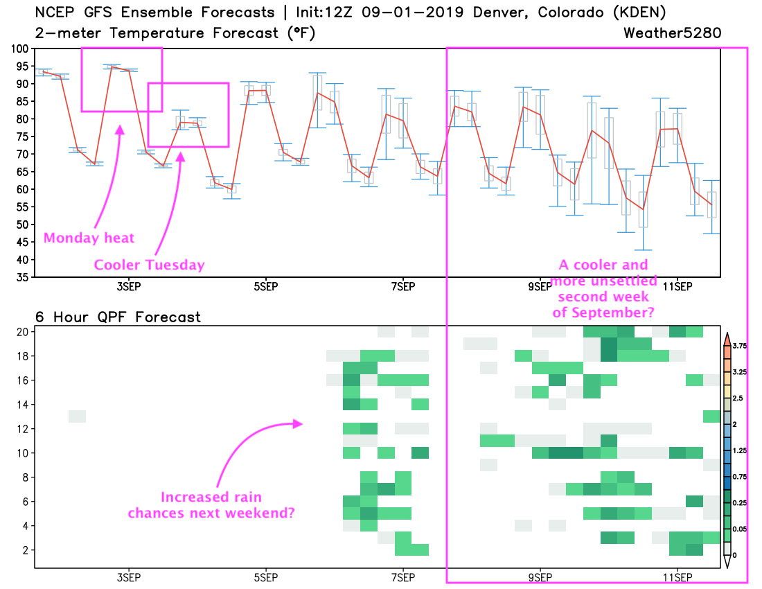
The GFS shows a cooler, wetter change on the way by next weekend. The European model has been more reluctant, especially with how much moisture next weekend's front will hold. It too, however, shows some cooler air arriving next weekend (it's all relative at this point) and sticking with us the following week. The GEFS ensemble forecast below shows the heat really backing off next weekend and into early the following week:
While the Euro mirrors this a bit... upper 90s today and tomorrow, briefly cooler Tuesday before upper 80s and low 90s return of the remainder of the work week... but then a good string of low to mid 80s forecast, and perhaps some better rain chances as well. Noticeably cooler than today's heat at the very least.
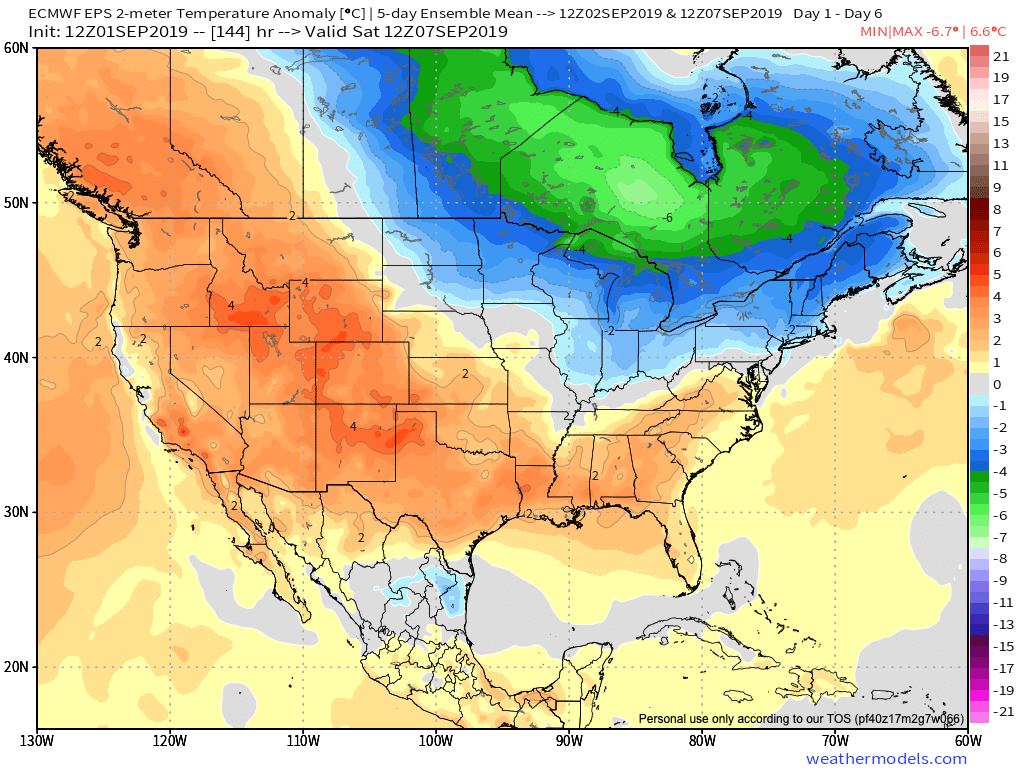
The 5 five day temperature anomaly forecast from the Euro ending the second week of September doesn't offer a ton of hope for a cooler second week as it has heat piling on for the Southern Plains and keeps eastern Colorado above average:
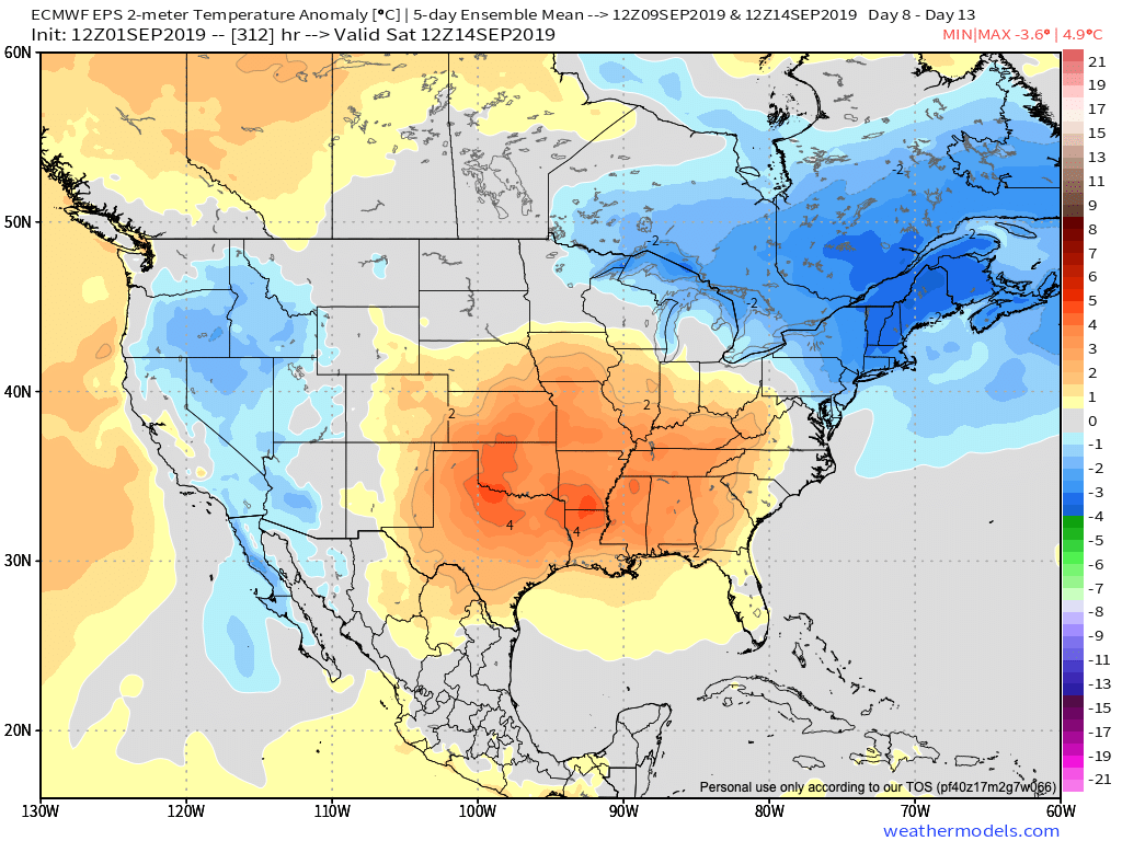
BUT it sure looks a lot better than this week for for the West including Colorado:
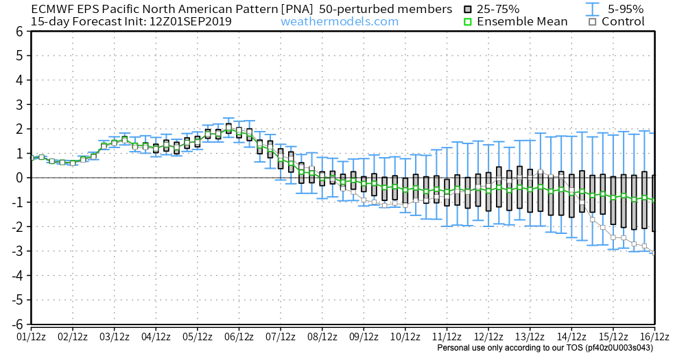
AND with a PNA finally forecast to go negative one might even be inclined to believe that cool signal showing up across the Great Basin. While maybe not screaming cold for us, it does show a window for some more active and perhaps cooler weather opening for us after this week.
Let us hope.