A Warm Saturday Ahead of a Strong Cold Front and Next Chance of Snow

As we discussed on Weather5280 Insider last night, our break from wintry weather will be a short one. Tomorrow highs will be in the 60s to perhaps low 70s across the region, before the bottom drops out Saturday night behind a strong cold front.
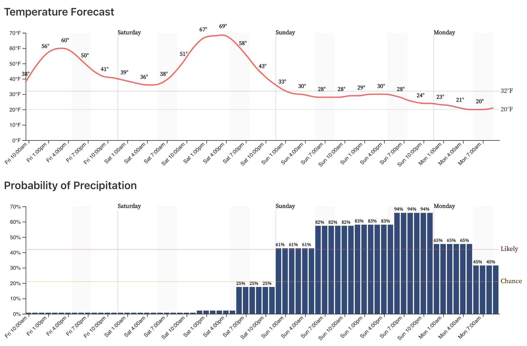
The hourly planner for Denver shows this dramatic change quite well, highs near 70°F Saturday, and not making it above freezing during the day on Sunday. There will be additional chances for pushes of arctic air on Monday and Tuesday, along with perhaps more snow as well. This post will focus on the Sunday to Monday timeframe.
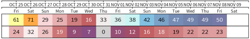
The European ensemble forecast keeps Northeast Colorado locked in the cold through most of next week. The GEFS has been more progressive, warming us up by Halloween of next week. However, recent trends have been toward the European solution and not the other way around. Take a look at these forecast temperatures for Denver by the Euro next week. Top row is highs, bottom lows. Teens and 20s Sunday through Wednesday, perhaps climbing just above freezing by Thursday:
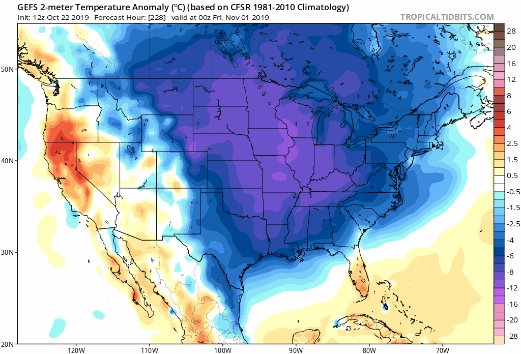
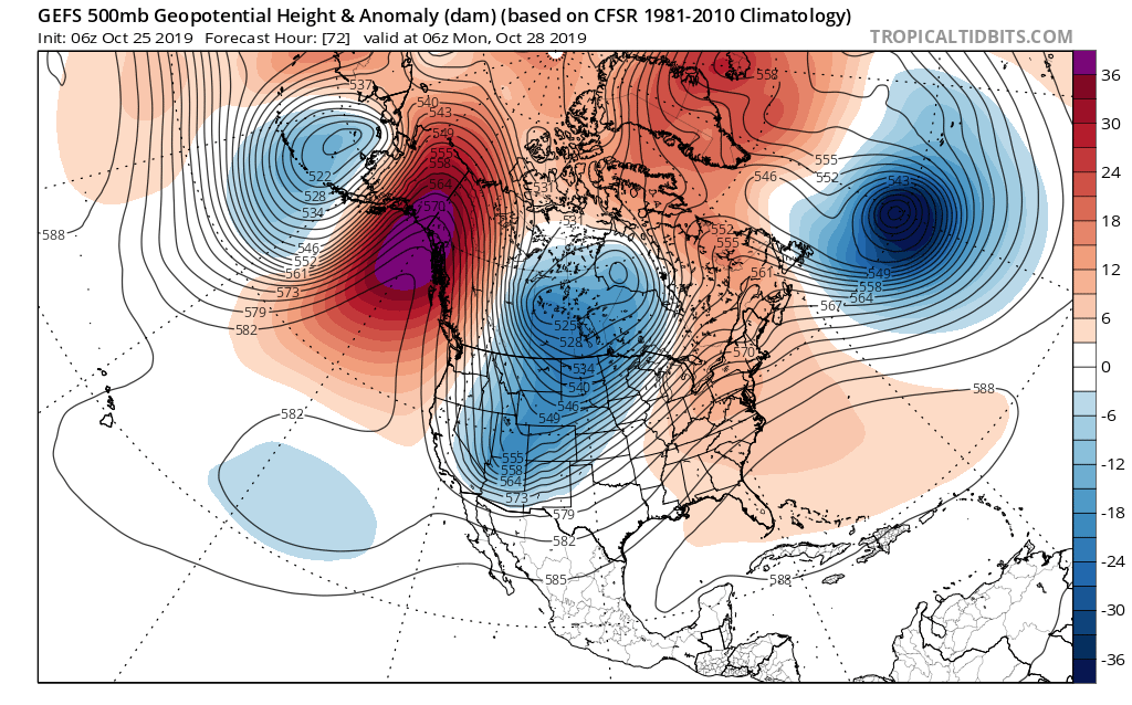
Now, if we look at the GEFS temperature anomaly forecast valid next Thursday evening... We see the coldest anomalies have been trending west over the last 12 forecast runs. You can see in the early runs it has some yellows across eastern Colorado and was progressive with the cold (covered all of the Eastern Seaboard), in its most recent run? Blues and purples over eastern Colorado, and above average temperatures now forecast for the East Coast. PLENTY of time for this to change over the next week, but a general comment that the GFS seems to be moving toward the European forecast, rather than the other way around:
Snowfall outlook
Along with the sharply colder temperatures will be another chance of snow, likely to deliver accumulating snowfall across much of the state from late Saturday night to Monday morning.
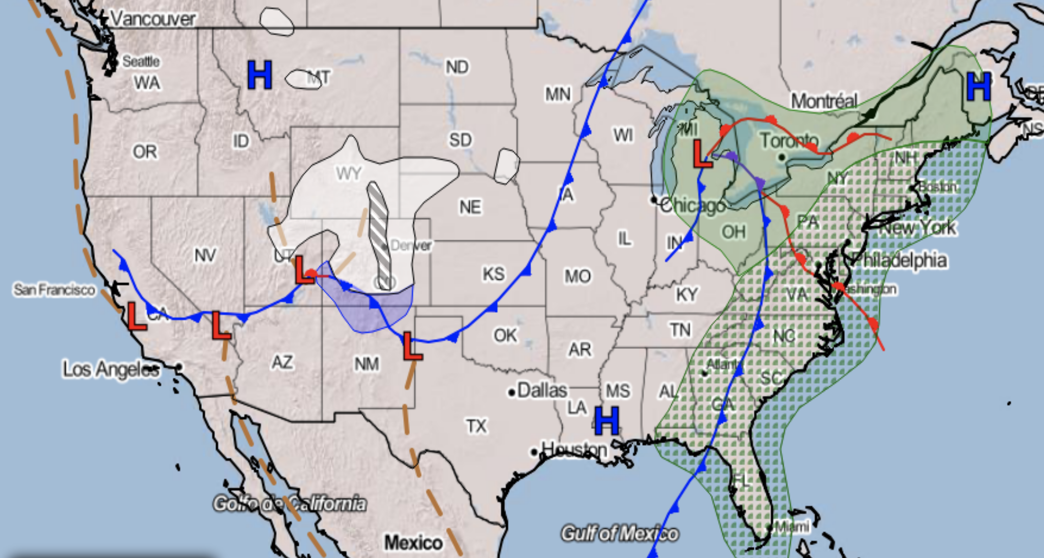
A large trough is forecast to dig into the Western United States Saturday night and will be responsible for delivery this big change to our weather. That in combination with a surge of arctic air, good upslope flow, and a jet overhead will all combine to bring us a good chance of snow to the state.
If you're in the mood for snow, this looks increasingly like a good setup for just that along the Front Range. We expect snow to start early Sunday morning across northern Colorado, with the heaviest snow across the greater Denver metro area currently forecast for Sunday afternoon and evening. Snow will continue off and on through Sunday night, before tapering off early Monday morning –– at least temporarily.
Just how much snow are we talking? Well, as we sit today it looks like many Front Range communities could end up with upwards of 5" of snow by Monday morning if things do not change dramatically between now and Sunday. These numbers could then be added onto between Monday and Wednesday as additional snow is possible.
If we look at the latest WPC 50th percentile guidance, it paints 5 - 10" for most cities from Colorado Springs north to Cheyenne. The greatest totals are along and west of I-25, with the exception being the higher terrain of Arapahoe/Douglas/Elbert counties southeast of Denver:
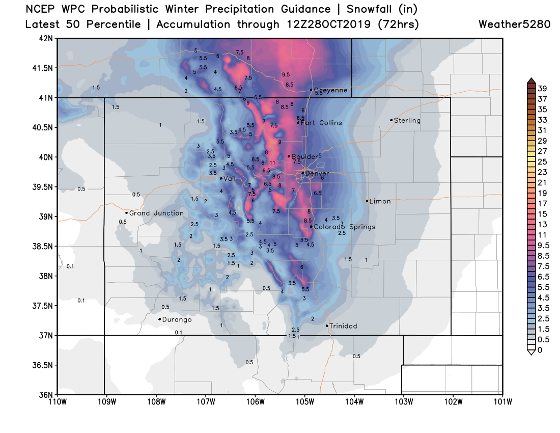
This map is not a bad starting point for totals. Of course as we get closer, we'll get a better sense of the potential with this storm as things will not doubt change between now and Sunday.
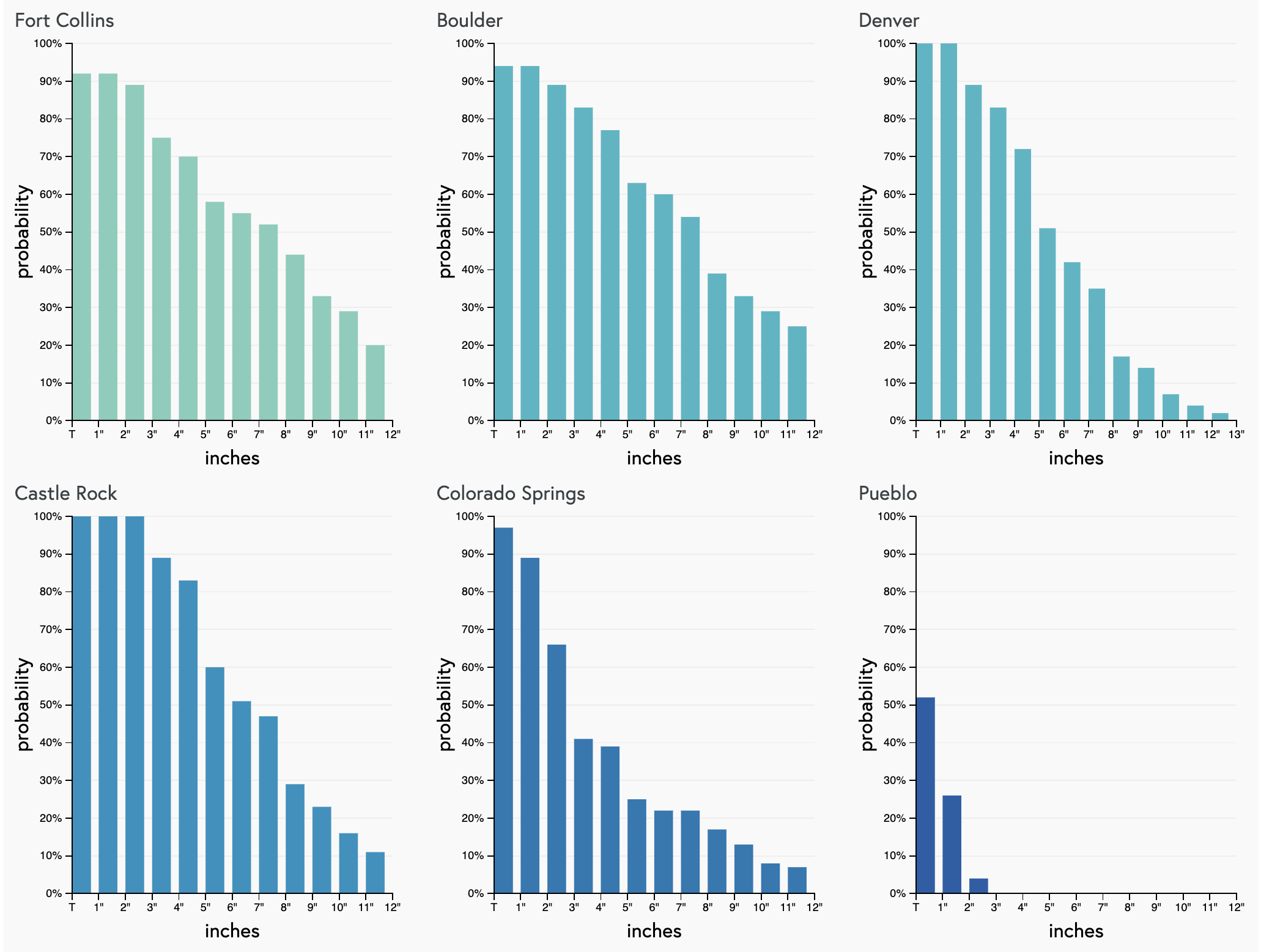
If we look at our gamblers from this morning, we see good odds for northern Front Range communities to see several inches of snow through Monday morning. Colorado Springs probabilities are lower, with the best chance for the higher end totals coming across the northern reaches of the city. These charts would indicate snowfall totals in excess of 8 - 10" is certainly a possibility.
Impacts
This is likely to be an impactful event for much of the state. This is especially true for the I-25 urban corridor and Front Range mountains. If you have travel plans this weekend, it's best to try to complete those by early Sunday morning, as conditions will deteriorate through the day Sunday into Sunday evening.
As things look today, the Monday morning commute is likely to be a slow one. This system is very cold unlike the last, so what snow we do see on Sunday and Sunday night will cause roadways to become snowpacked and icy.
Additionally... some models are slower with the best snow chances, and drag snowfall well into Monday morning across the greater Denver area. If this this is to be the case, impacts of course will be much higher for your Monday drive.
While air temperature will be quite cold, the ground is still relatively warm –– even after our most recent storm. Melting will occur on paved surfaces at least initially, which will add to the icing concerns Sunday night into Monday as temperatures continue to fall.
Looking ahead
Differences in the data start to arrive Monday and so forecast confidence goes down a bit as we head into early next week. It does appear as though reinforcing shots of cold air are quite possible (if even likely) both Monday night and Tuesday, and with them the potential to see addition snowfall across the region.
For now we'll focus on the Sunday to Monday morning timeframe, then discuss the additional snow chances in future updates. Right now it looks like if we are to get additional accumulating snow it would come in the Tuesday midday/Tuesday night timeframe.
This will be the first extended cold snap of the season. That, in conjunction with a good chance of snow means this is liable to be an impactful event across the region. Make your winter preparedness plans now, enjoy the day on Saturday, and stick with us for updates as we head into the next several days.