Winter Weather Advisory Posted for Sunday And Monday, Additional Snow Likely Through Tuesday Night

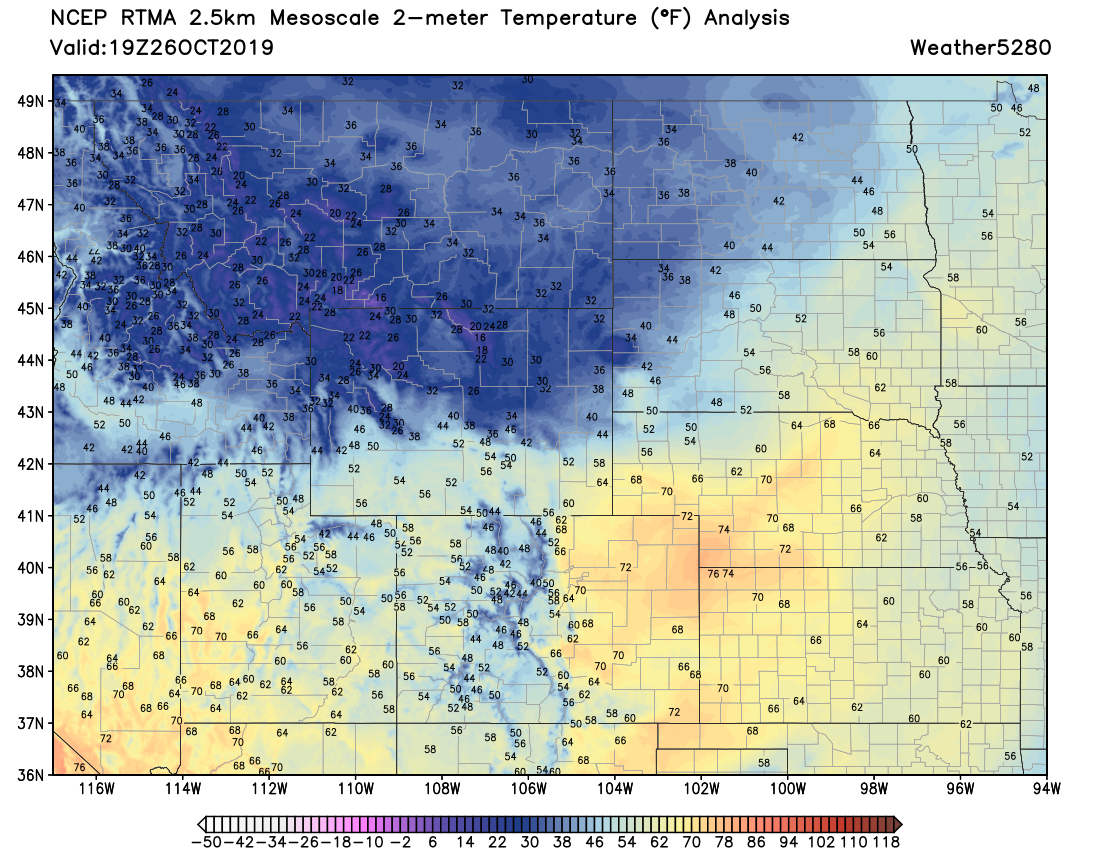
Changes are on the way, even as temperatures have climbed into into the low to mid 70s this afternoon across Eastern Colorado. A look at current temperatures across the region show the afternoon warmth... but to our north? Plenty of cold looms.
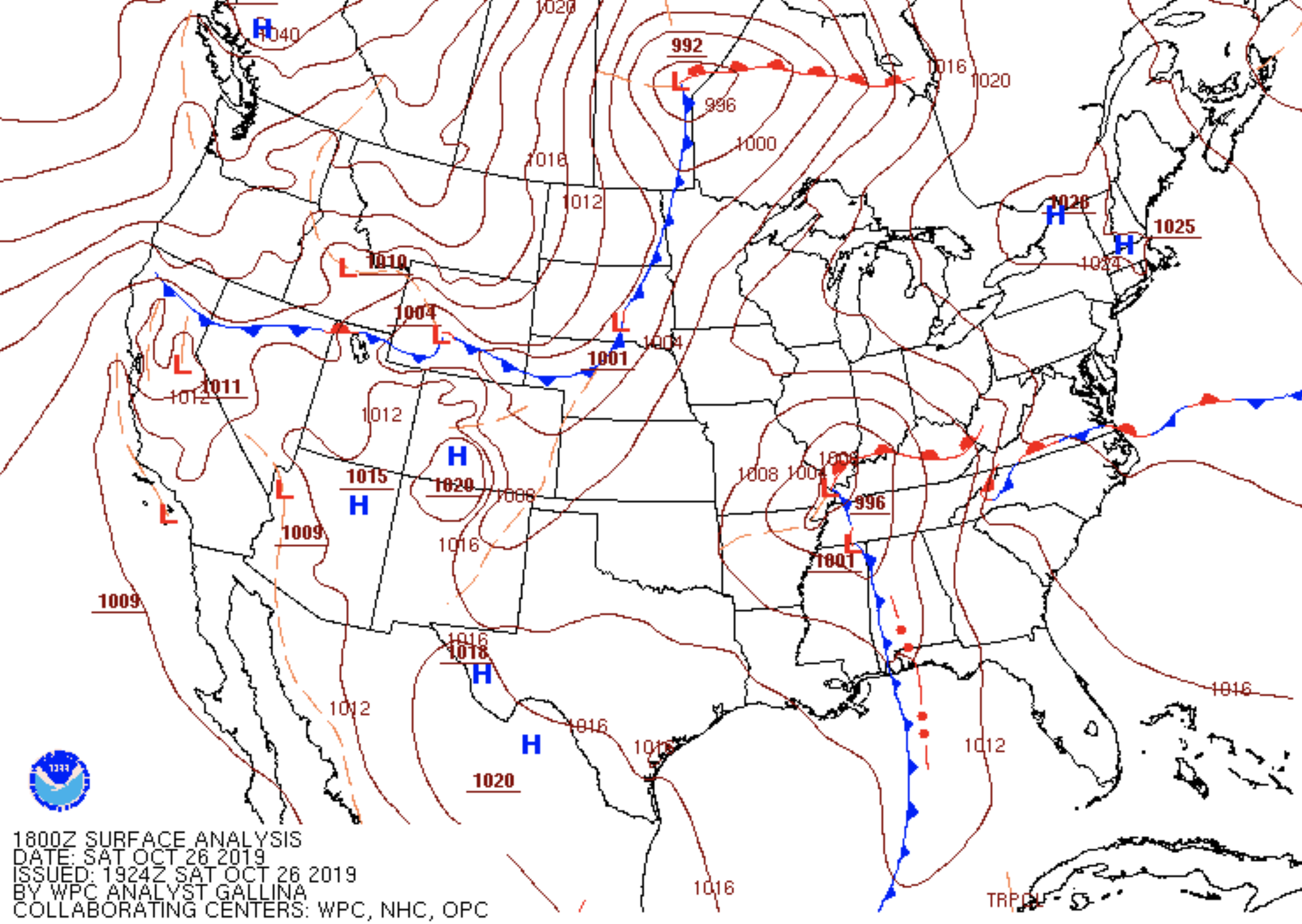
Latest surface analysis shows just what you'd expect from the image above. The initial surge of cold air is racing through Wyoming and getting to set plunge into Northeast Colorado later this afternoon and evening:
Behind the front we'll see temperatures plummet. We currently expect temperatures to stay below freezing Sunday though Wednesday as several surges of cold air will work to keep us in the icebox for an extended period of time.
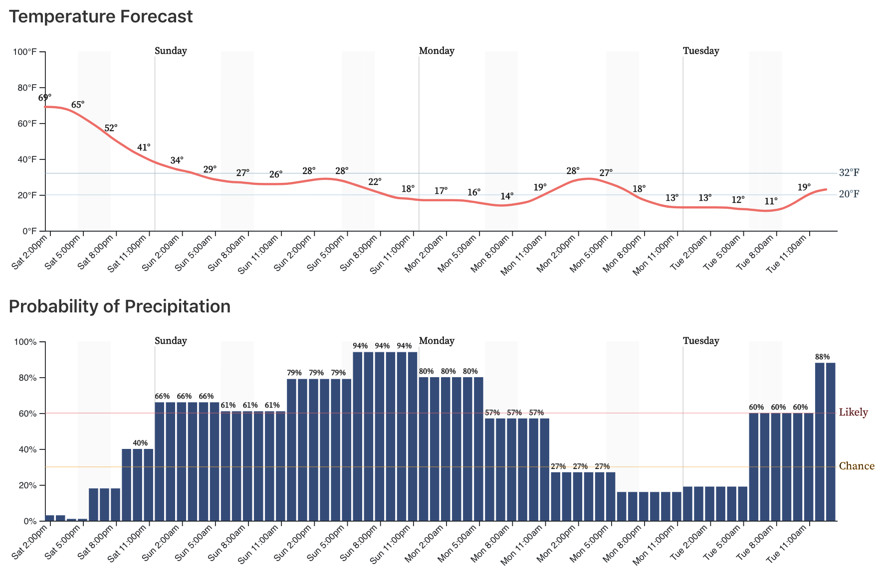
If you look at the hourly forecast through Tuesday midday it's clear to see the dramatic drop in temperatures on the way, as well as the good chance of snow. Note that precipitation probabilities enter the likely range tonight and will stay there well through Monday.
We may see some drizzle and freezing drizzle initially overnight tonight, but as we head into Sunday day and beyond snow will be the word.
Snowfall forecast
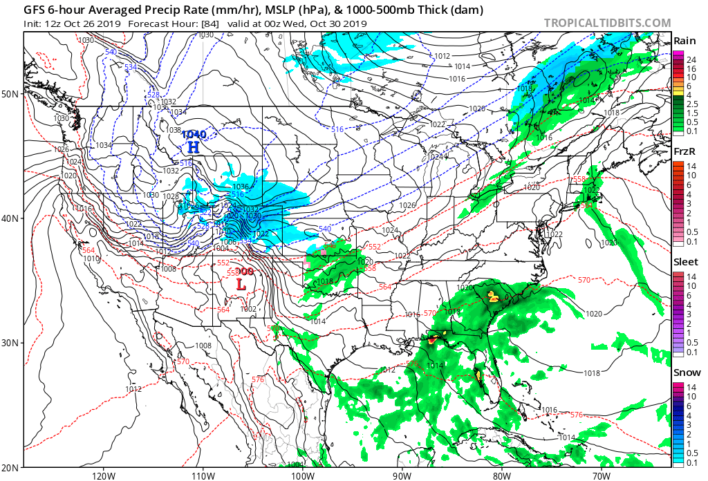
Modeling has been fairly consistent in recent days with regard to the next four days or so. We'll see TWO main waves of snow, the first Sunday into Monday, and the second Tuesday into Tuesday night. Both are likely to bring accumulating snow to the Front Range and urban corridor.
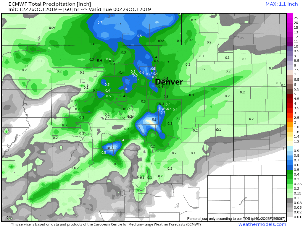
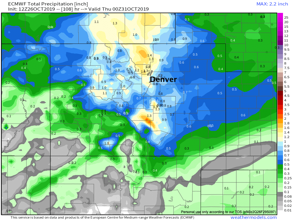
If we look at the precipitation forecast from the Euro, first through Monday evening (top), then through Wednesday evening (bottom), we see the global models are quite bullish on total precipitation through both events, with roughly 0.4 to 0.6 QPF for both rounds, and final tallies upwards of 1" across much of the region. While the GFS shows similar numbers, the spatial placement of those totals varies, the GFS for example has more downsloping (lower totals) off the Cheyenne Ridge, which if correct would equate to lower totals for northern Eastern Colorado communities.
Precipitation forecast Sunday and Monday:
TOTAL precipitation Sunday through Wednesday:
With snowfall ratios expect to be greater than the 10:1 (snow/water) ratio you'll see on a typical snow map, you can see how even if models are overdoing QPF as they often do, some fairly significant totals will be possible across the region when all is said and done Wednesday.
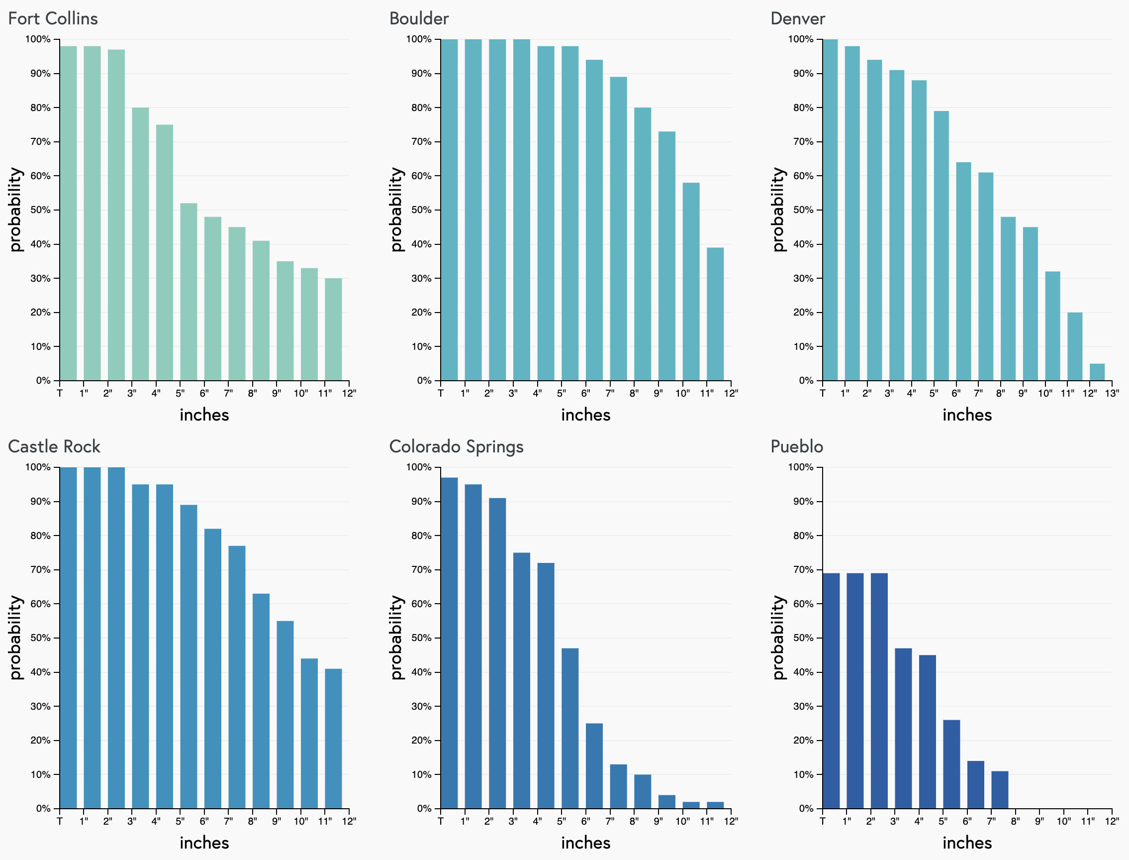
With this, it shouldn't come as much surprise that our gambler charts are about excited about snow as they have been in some years (or so it seems). Here are the probabilities through Monday for cities along the urban corridor. Note: these do NOT include snowfall chances Tuesday into Wednesday. Our gamblers are sniffing out some downsloping problems for Fort Collins but this might be overdone, and otherwise we see very solid high-end probabilities for Boulder, Denver, and Castle Rock:
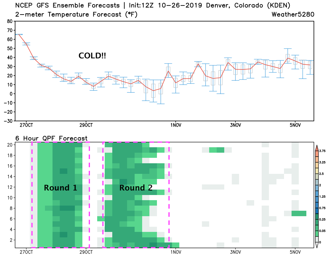
And finally, a check on the all important ensembles. First for the top half of the chart below, great agreement from each of the GEFS ensemble members that we are entering an extended period of COLD weather! Below you can see quite clearly the two rounds of snowfall we've been discussing. Of note, GOOD agreement between each of the ensemble members on both timing and intensity of the expected precipitation:
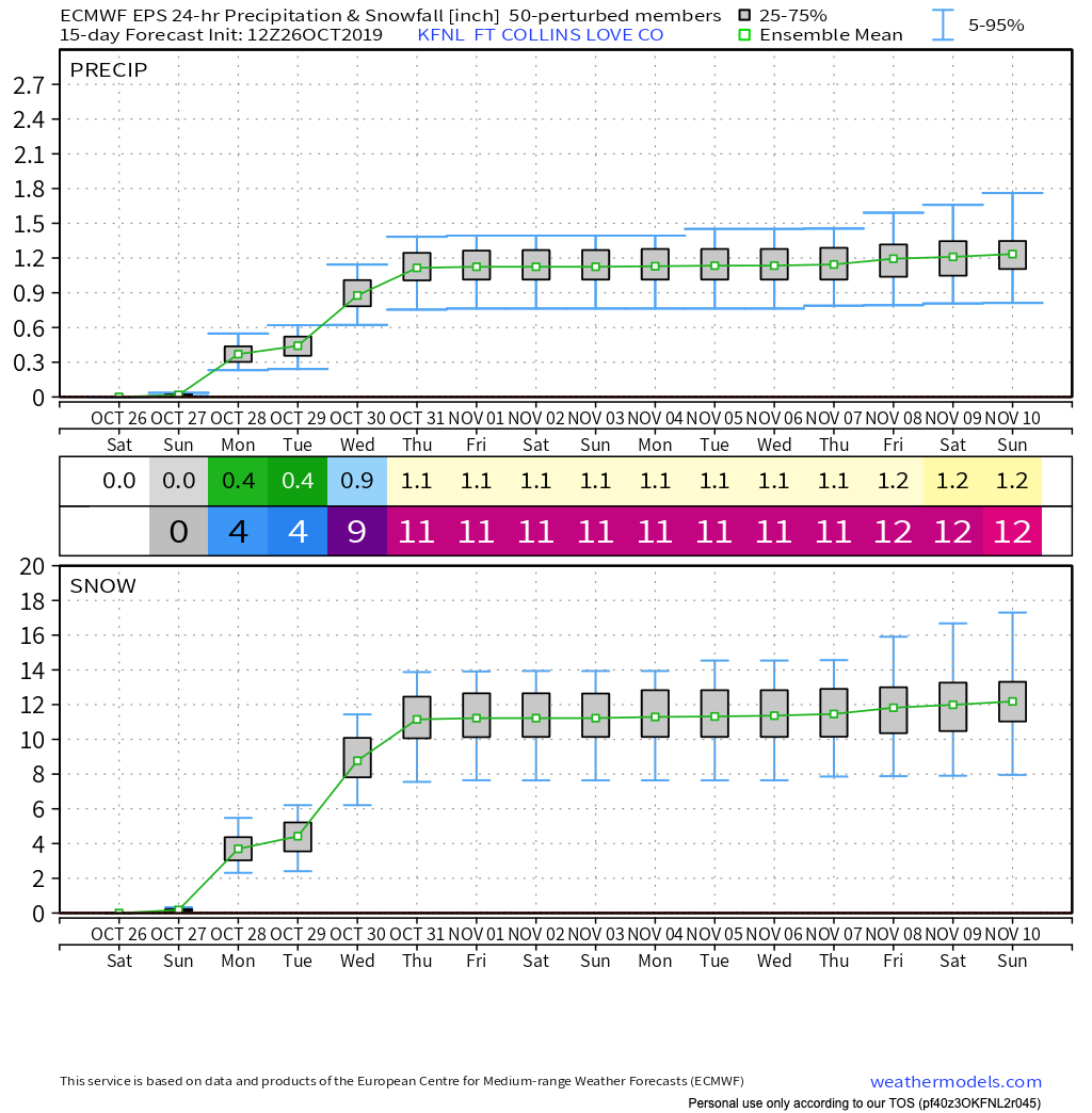
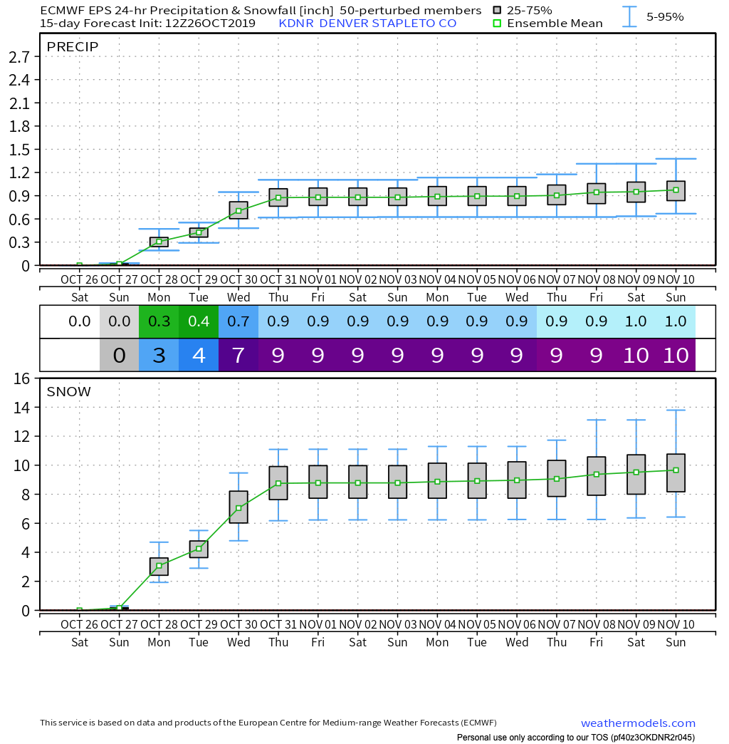
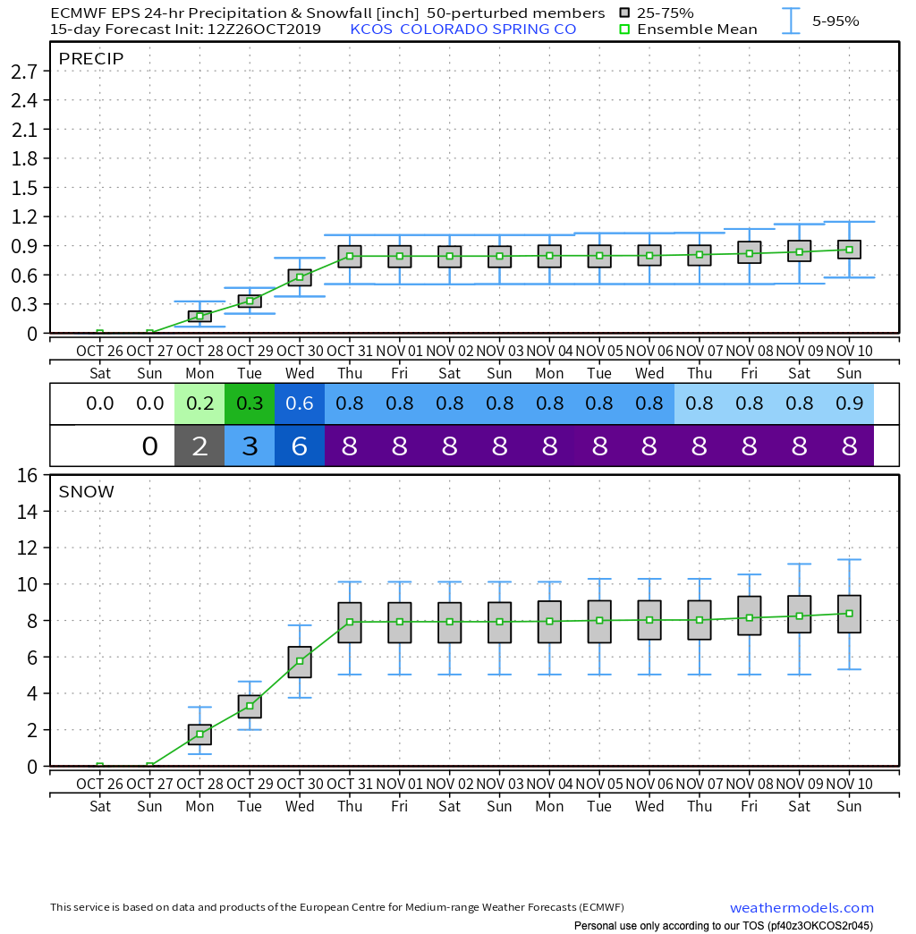
Similarly, we see a rather bullish ensemble mean forecast from the European as well. Here's a look at its forecast for Fort Collins, Denver, and Colorado Springs.
For Fort Collins we see the ensemble mean is OVER 1" of liquid through Wednesday, which IF CORRECT would equate to well over a foot of snow given the higher snowfall ratios we expect with the accompanying cold.
For Denver, 0.9" of liquid from the two storms combined...
And finally, Colorado Springs, with 0.8" liquid forecast:
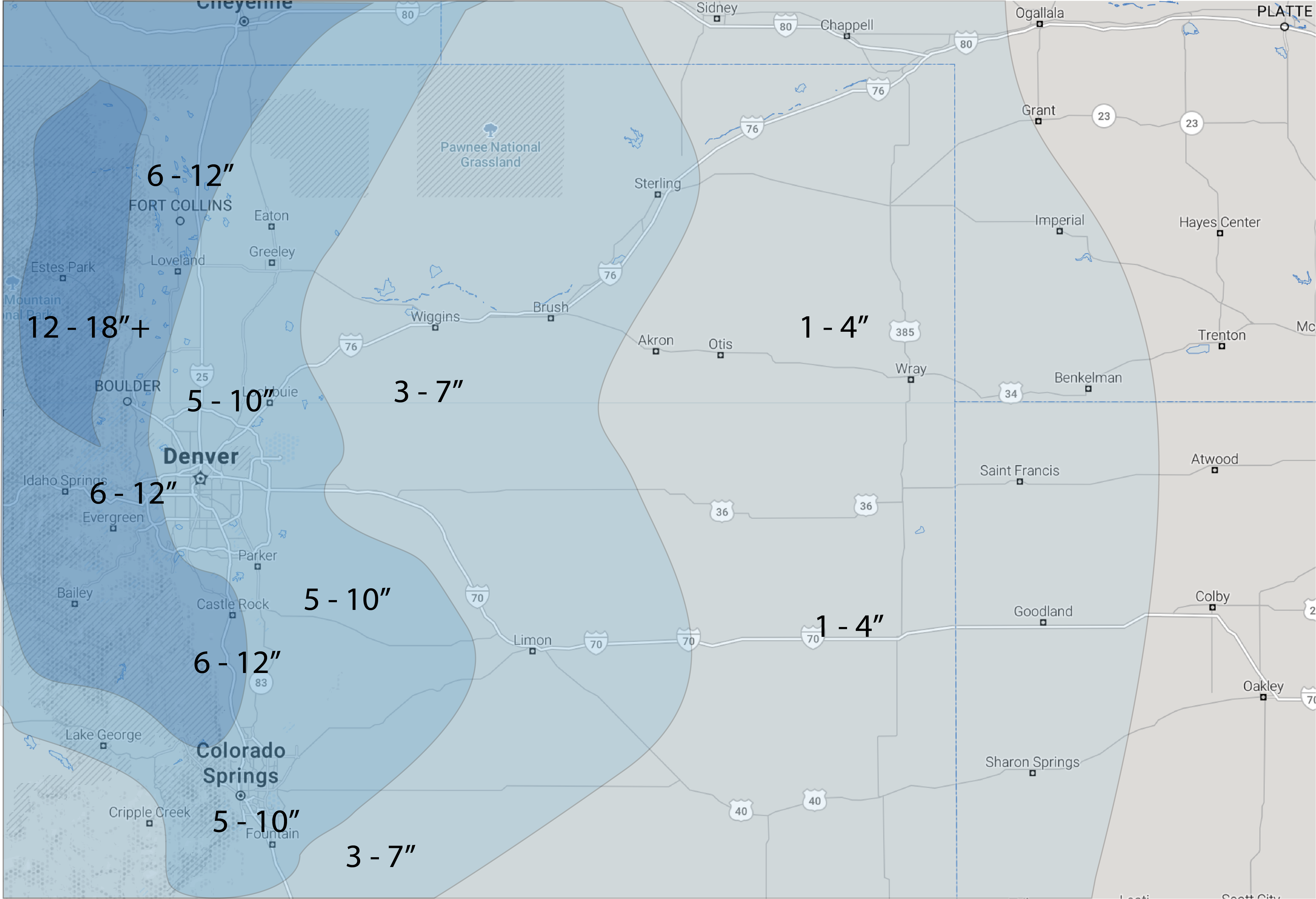
For our forecast, we will issue one for Sunday and Monday today, then a secondary snowfall forecast for Tuesday in a later post. The map below accounts for snowfall through Monday PM only. So please don't wake up Sunday morning expecting these totals –– they will come with time (if all goes as forecast), and much of this won't fall until later Sunday overnight into Monday morning.
Most cities along the urban corridor will see 5 - 10" of snow during this period. For Colorado Springs odds are a bit lower, so some 3 - 4" totals wouldn't be shocking. Now, that said, the latest European operational run was more bullish for COS, especially on the south side, so will keep it in the 5 - 10" range to account for this a bit. For communities west of I-25 heading up into the hills, 6 - 12" will be possible, and even more for the northern Front Range mountains. We've included Fort Collins in the 6 - 12" range largely due to the QPF forecast from the Euro being pretty stoked on snow for the Fort with this system. Bust Index is middle of the road across the board, with no glaring concerns outside of normal snowfall forecast challenges.
Impacts and considerations
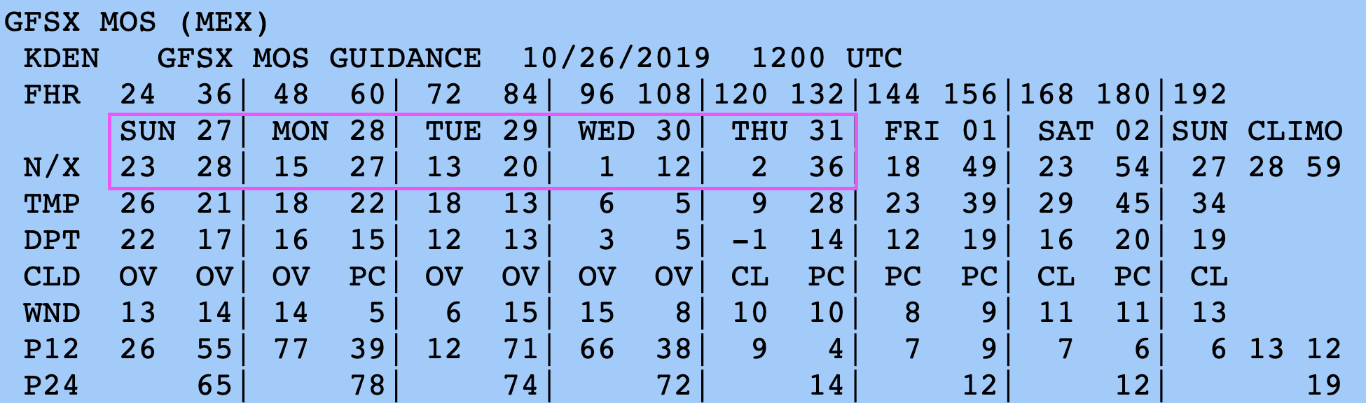
Not to get lost in all of the excitement around the snow, is this will be a VERY cold period as well. The latest GFS MOS guidances paints lows as cold as 1°F by Wednesday morning, with highs below freezing through Wednesday for Denver:
With that, the snow that does accumulate will be quite impactful, especially if we do see drizzle later tonight into early Sunday. Roads will become snow packed and icy, and will likely be so for several days.
Right now the worst commutes look to be Monday morning, Tuesday evening, and Wednesday morning. We can say with reasonable confidence, however, that travel won't be fun from Sunday afternoon through Tuesday night across the region, with just a few lulls in the action. Please plan accordingly.
We'll keep pushing updates over the next several days.
Buckle up! Stay warm! and stay tuned!