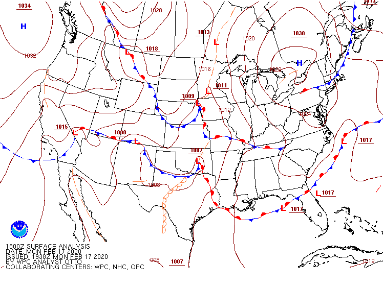
Monday PM update: A check on this week's snow chances as first cold front arrives

In case anyone thought this morning might offer some clarity in how the next several days are set to shake out, you can rest assured it did not. This is a messy setup to forecast, and an even messier one to communicate.
We'll hit a couple of bullet points right off the top here:
- We are still primarily tracking two snow chances this week, one tonight into Tuesday morning, and a second on Wednesday.
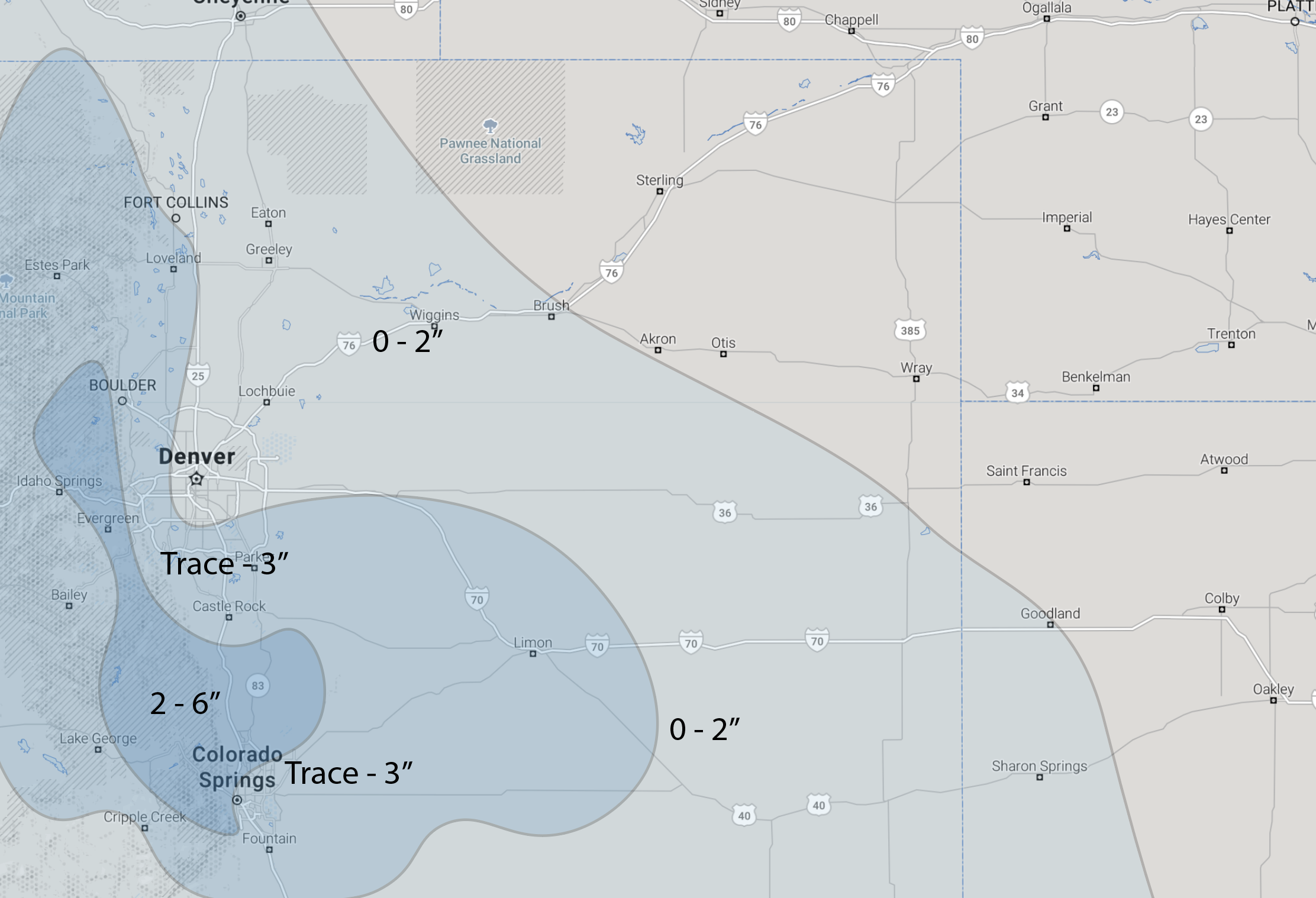
- Despite a high uncertainty forecast, we'll mostly stick with our forecast from yesterday for tonight and Tuesday, with the greatest potential for several inches shaping up to be in the foothills west of Denver, across the Western Palmer Divide, and then down into the Colorado Springs area. Some models have 1 - 3" across the Denver area with round 1, but others are bone dry. We will continue to hedge on the low end for tonight/tomorrow for Denver and north (we have 0 - 2" for Denver), with that better potential south and west of the city tonight.
- We talk a lot about ensembles vs operational model outputs. There is VERY little agreement between the two with this week's events, and worse a ton of fluctuation in each model run as to where the heaviest snow ultimately ends up. The European has been the most consistent, so we'll be hugging it until we see a good reason to change.
Timing
For a bit of context before we talk about snowfall potential, here's the general timing of the two waves of snow we're discussing.
For Denver, look for the chance of snow to increase this evening and be greatest between 8pm tonight and 11am Tuesday. Perhaps we don't see a lot of snow, but we do think we'll see some in most cases across the metro. Not a sure bet on a bad commute Tuesday morning, but give yourself extra time just in case.
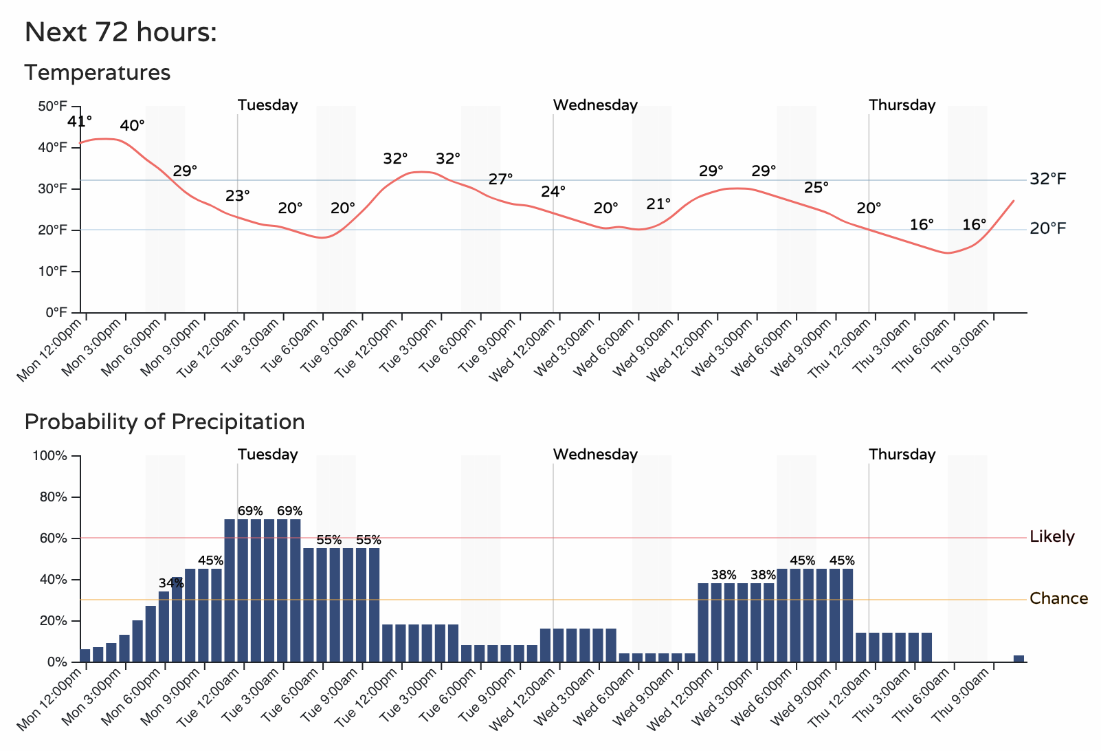
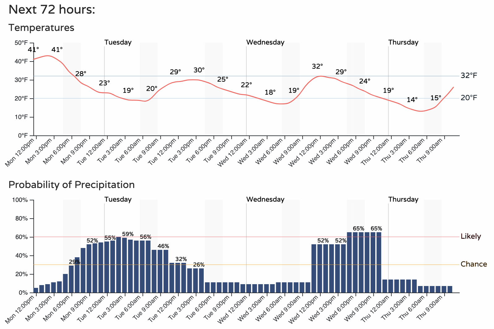
For Colorado Springs a similar look. The chance snowfall category is a bit longer of a window than in Denver. For both cities we see temperatures staying at or below freezing from this evening through Wednesday, with that secondary chance of snow Wednesday afternoon and evening:
Right now the commute most at risk from round 1 appears to be Tuesday morning. If we only manage low-end totals there will be no issues on the roads in Denver on Tuesday, with main impacts across the higher terrain south and west and across the Colorado Springs metro. If we manage high-end totals, the Denver metro area will also see that morning commute impacted.
Snowfall totals
We'll continue to focus on tonight / tomorrow, and worry about Wednesday in an update tomorrow. You'll likely see totals thrown around for both systems together and each individually and it'll be hard to keep track what is what. The confidence in the forecast, we feel, is simply too low with round 1 alone that grouping in the second snow chance with it would only add to the confusion.
With that, below is our latest forecast through Tuesday evening. We continue to think that IF we see heavier totals (or even a boom?) it'd be west or south of Denver, generally were you see the 2 - 6" range in the map. Colorado Springs generally has a higher potential for greater snowfall than Denver and points north. Low end total for the northern urban corridor are 0" and a Trace.
If we look at various models through Tuesday evening we see the following.
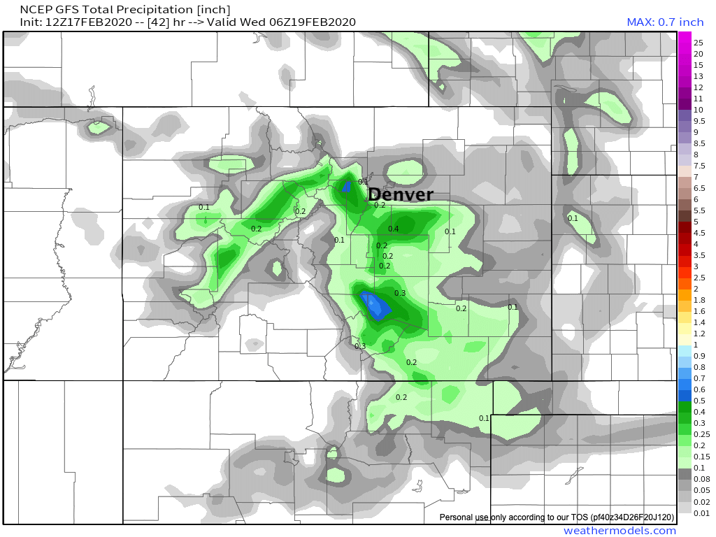
GFS model
One of the wetter models at the moment, especially for the foothills west of Denver and Palmer Divide. If correctly totals upwards of 5" will no doubt be possible in our 2 - 6" range zone. For Denver it'd equate to not much across the northeast side of town, and 2 - 5" across the southwest side. Like most models, it shows some high-end potential for COS, especially western COS.
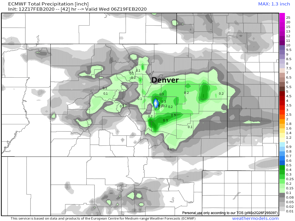
European model
Far less potential west of Denver, with generally a tenth or less of precipitation across Denver, and 0.1 to 0.2" for the foothills. It has been very consistent in bringing the most moisture to western and northern Colorado Springs, where if correct, upwards of 5" would be possible if not likely.
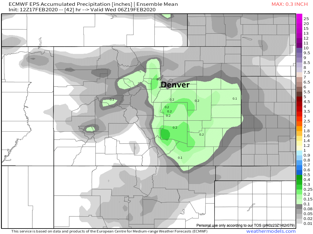
European model (ensemble mean)
The Euro mean also has a bullseye of heavier QPF across Colorado Springs, though far less pronounced vs its operational run above. Still, at 0.2" (or so) liquid, 2 - 5" seems like a reasonable idea for the west side and Trace - 3" southeast.
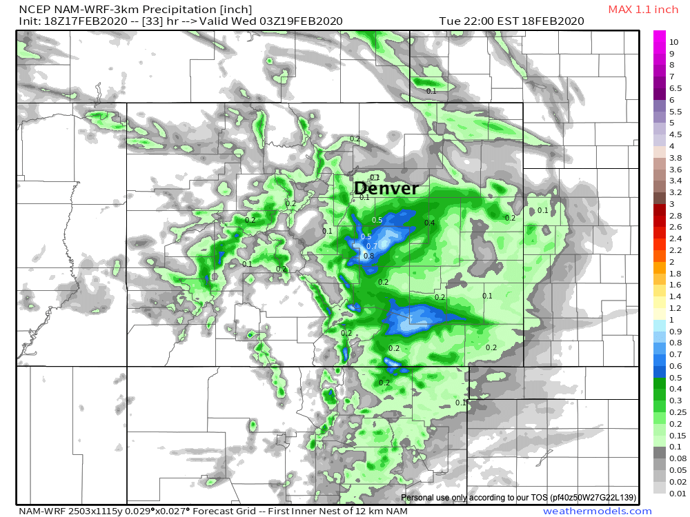
3km NAM model
To put some emphasis on how bit a disaster this setup is in the models, here's the high-resolution 3km NAM forecast. For Denver and surrounding area it seems reasonable, suggest we see 0 - 2" as we have outlined. For Colorado Springs... this would blow our forecast out of the water as it covers the entire metro in 0.6 to 0.9" liquid... which would imply a foot is possible in spots. We've outlined for clients that a foot is not out of the realm of possibility this week across the Colorado Springs region, but that the probability for that occurrence remains LOW.
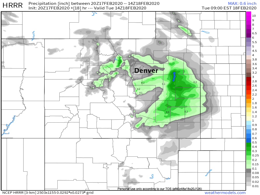
HRRR model
The latest HRRR is essentially painting a non-event for most areas tonight into Tuesday morning and is pulling the heaviest precipitation well east. We've seen this from time to time in other models as well, so we'll see if it pans out. If so, our 2 - 6" zone will bust hard, but zeros across the Denver area will do just fine! 🙃
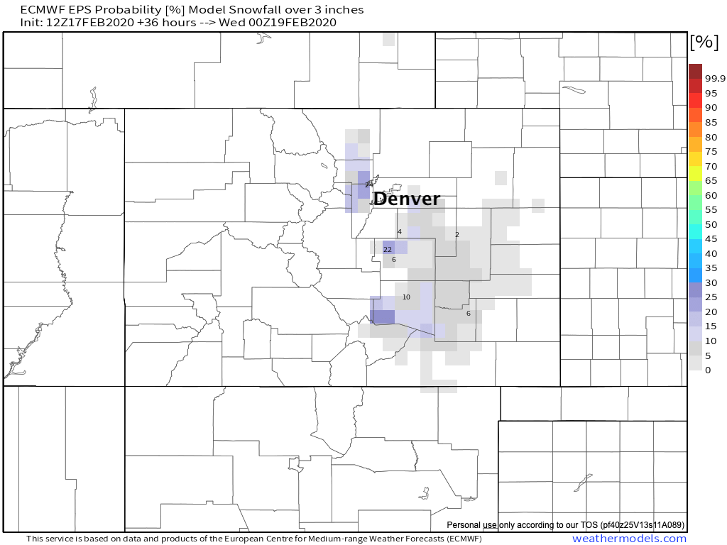
AGAIN, there is a LOT of noise with this one. As we stated above we're going to stick with the Euro until it flips or we see otherwise. If you contrast that 3km NAM with the European ensemble probability of 3" of snow or more through Tuesday afternoon, it's easy to see the problem. High-res models going crazy, the trusty Euro mean showing odds of more than 3" (let alone a foot!) at just 10 to 20% or so for the COS region:
Planning
I think it's best to just plan on following the timeline above for the best chances of snow in the coming days. Give yourself extra time on the roads in case, but until we see things setup heavier than we anticipate, we'll plan on more reasonable snowfall totals than the 3km NAM or GFS would suggest.
Boom potential remains highest across COS, the Palmer Divide and foothills immediately west of Denver -- but the probability for that boom is low we believe.
We'll be watching things tonight and see how everything evolves. If we see something shaping up dramatically differently than what we've outlined here we'll try to pass that along, otherwise we'll touch base on Wednesday tomorrow.