
A warm wind and a cold wind, tracking temperature extremes across Northeast Colorado

It'll be another day of temperature extremes across Northeast Colorado, much like we saw play out all day Sunday across the region.
The extraordinary wind event Sunday, which fueled a brush fire on Denver's west side, also helped keep much of the urban corridor quite mild through most of the afternoon, before finally losing out a wind shift and pool of bitter cold air parked over the Northeast Plains Sunday evening.
Winds off the mountains helped keep the immediate plains quite mild, while just miles north and east highs never managed to do much better than the teens for highs in many instances. As the wind died Sunday evening, the cold air advanced west, dropping the temperature in Denver some 45°F in just hours.
Check out the temperature drop measured at DIA Sunday!
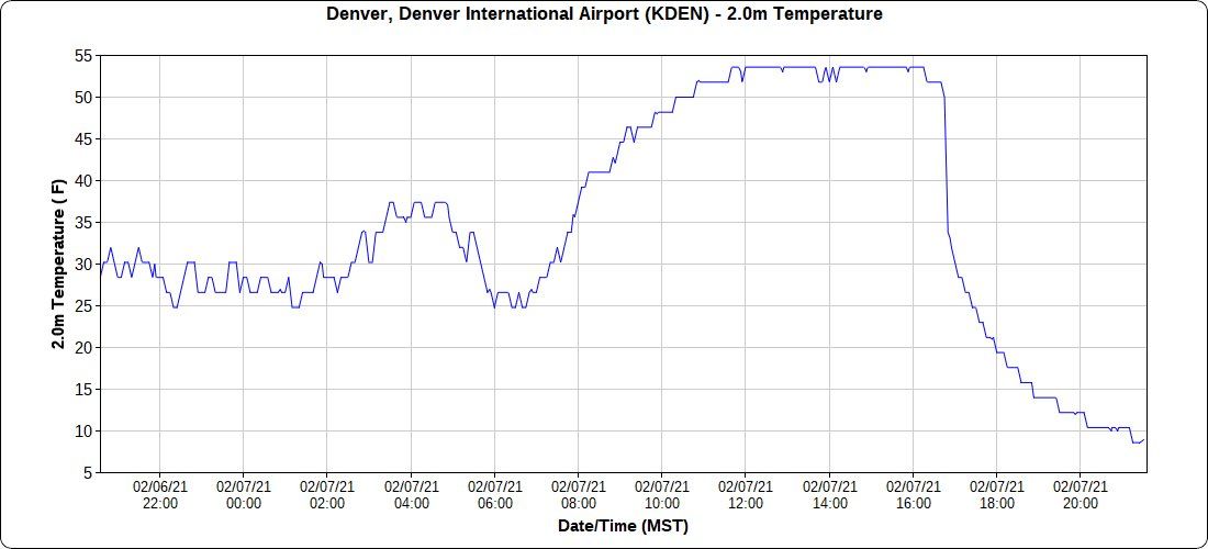
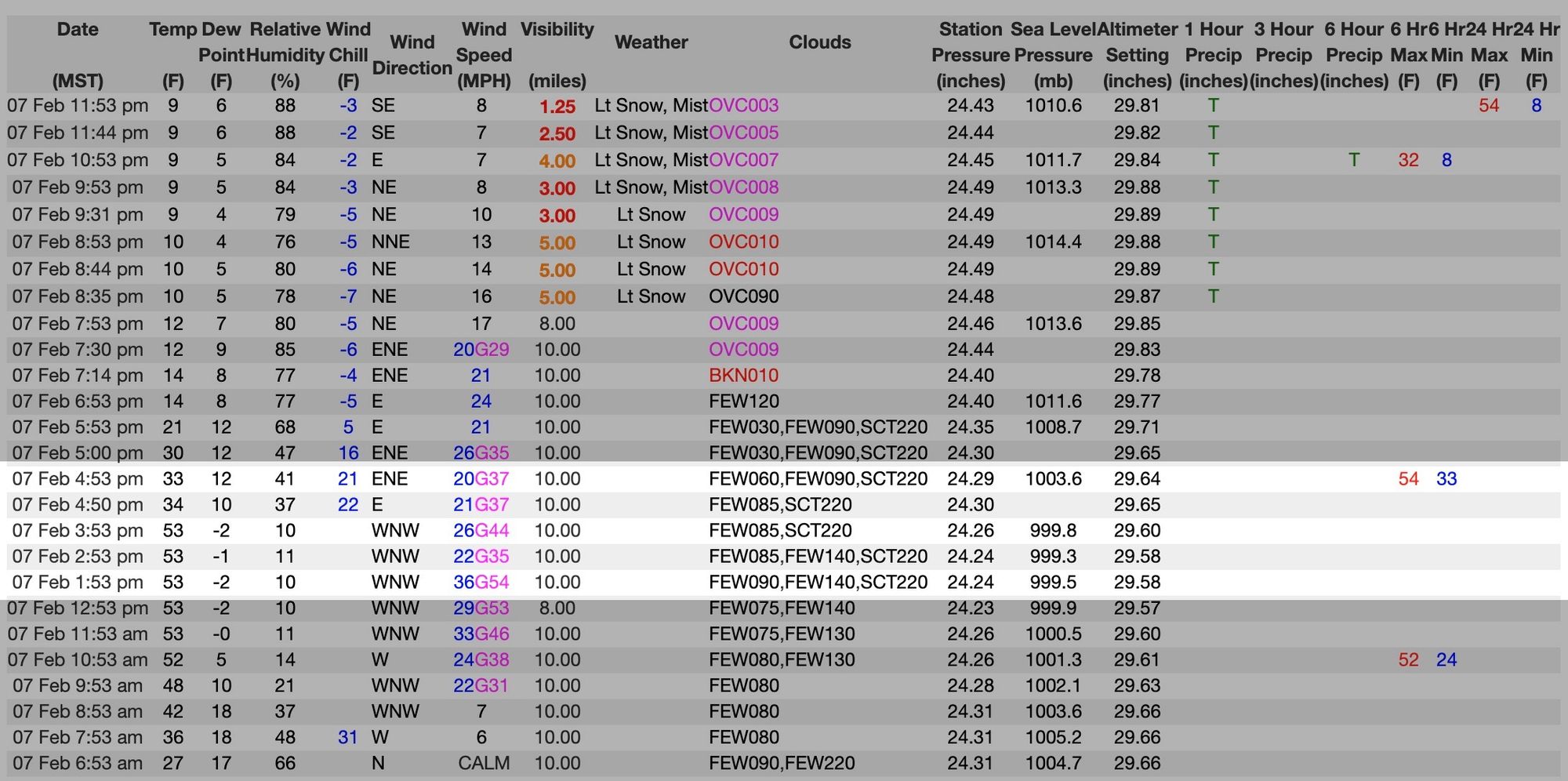
Looking at the tabular observations for yesterday for Denver we see the dramatic shift play out plainly as the westerly (warming winds) give way to the colder easterly/northeasterly winds late in the day – cold air advection at its finest. AT 3:53pm Sunday DIA was 53°F degrees with a WNW wind gusting to 44mph. An hour later the temperature had dropped to 34°F, a wind chill of 22°F, and a E wind gusting to 34mph!
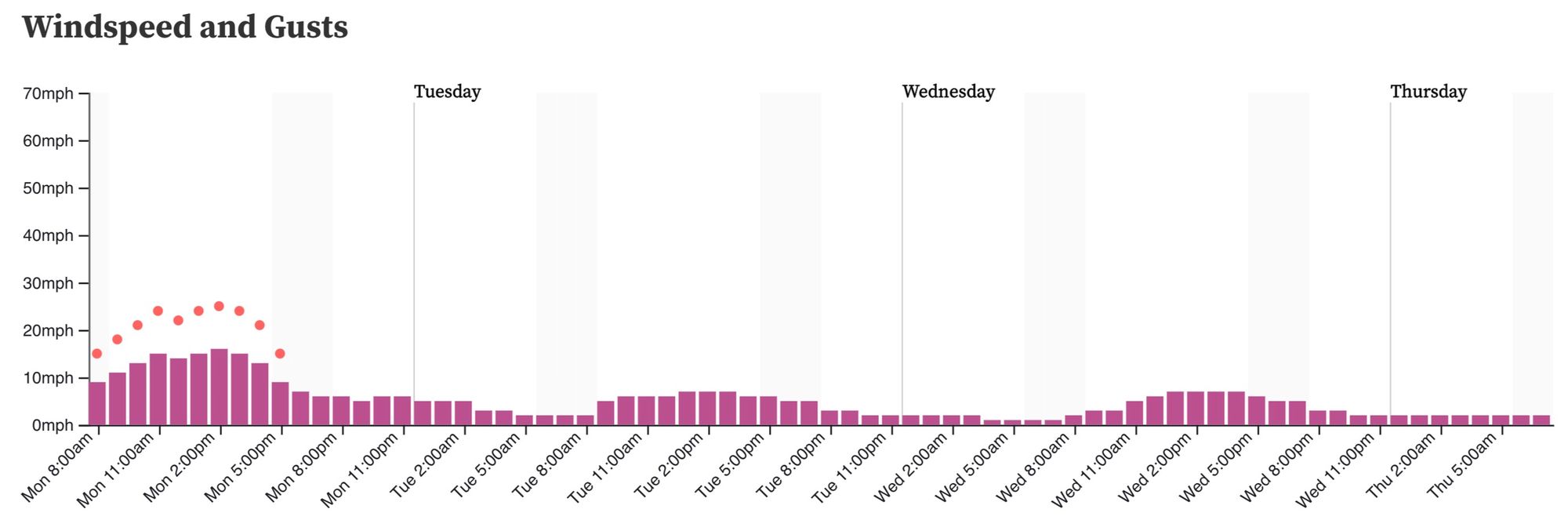
Winds aren't forecast to be as strong today along the foothills, but will still be gusty at times. A Red Flag Warning is in effect for the foothills immediately to Denver's southwest. In Denver, look for those wind gusts to pick up again this morning, with gusts to 30mph through early this evening before calming once more:
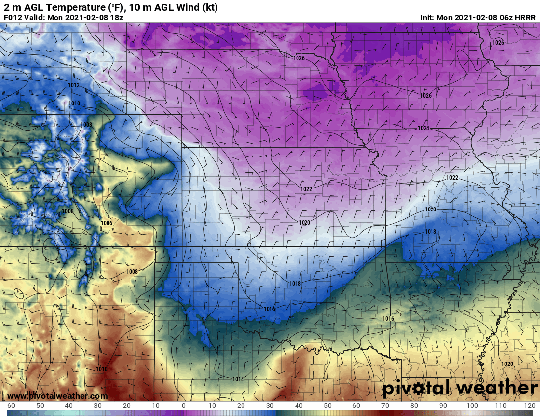
These westerly winds are again forecast to mix out the coldest air much quicker right against the hills and Palmer Divide this morning, with the cold low-lying areas across the plains staying much colder this morning. Look at these incredible temperature gradients across Eastern Colorado this morning!
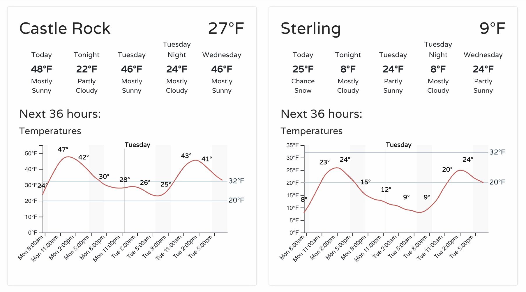
With that, expect another day quite varying weather across Northeast Colorado. A great example is comparing the outlook for Castle Rock and Sterling. Highs in Castle Rock are forecast to push 50°F again this afternoon, while Sterling may struggle to hit 25°F, with even some light snow being squeeze out. This morning Castle Rock is already nearing 30°F, while Sterling is stuck in the single digits as of 8:45am.
This battle will continue to play out through the end of the week. At times the cold will prevail, and we'll get dramatically colder along the Front Range. Other times the warmth will hold, and we'll be quite mild even as temperatures will remain in the deep freeze just up the road from the metro areas.
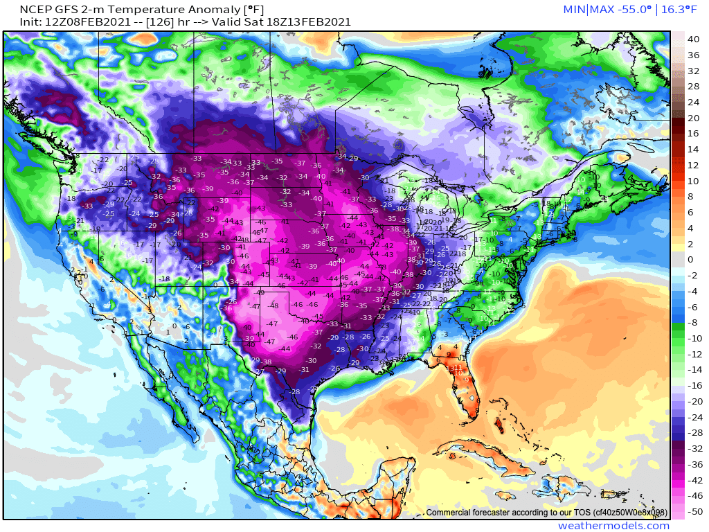
By late week and next weekend some models continue to show the cold winning out in entirety. As we discussed yesterday, however, that there's still considerable disagreement in the modeling with just how extreme the cold will be, and how far west it'll deliver the greatest impacts.
The GFS continues to show the most extreme solutions – dropping temperatures some 4o to 50 degrees below average across all of Eastern Colorado by Saturday morning (lows some 10 to 15 below zero for the Denver area):
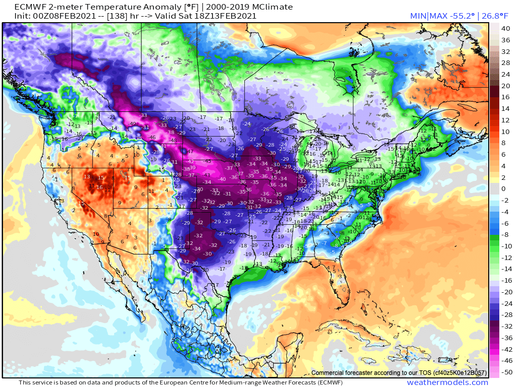
The Euro came in colder last night, but still keeps the greatest anomalies east and northeast of the greater Denver metro area for the same time:
No doubt plenty of cold air to work with, and if yesterday shows us anything it's that it can push in to the area in a hurry!
We continue to watch.