What has overnight data revealed about Colorado's weekend snowstorm: Wednesday update
Data is in from the overnight and morning and shows little change to our continued focus on a significant snowfall event this weekend for Northern Colorado (especially the foothills), Eastern Wyoming, and Nebraska.
Let us take a moment to make one thing clear, we are focused on the weekend event in this post but there are snow and rain chances before we even get to the main storm; rain/snow chances increase now through Friday. If need be this will be addressed in a post later Wednesday that will focus on the near-term forecast.
Let's compare the overall pattern of the incoming storm, beginning with the middle atmosphere.
The position of the storm is shown here as a closed-low as it developed from the Four Corners and sits over southeastern Colorado by late Sunday, before ejecting east/northeast. You'll note, that this track from the European ensemble model doesn't look all that different than what we shared with you 24 hours ago.
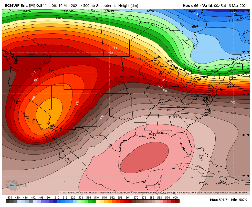
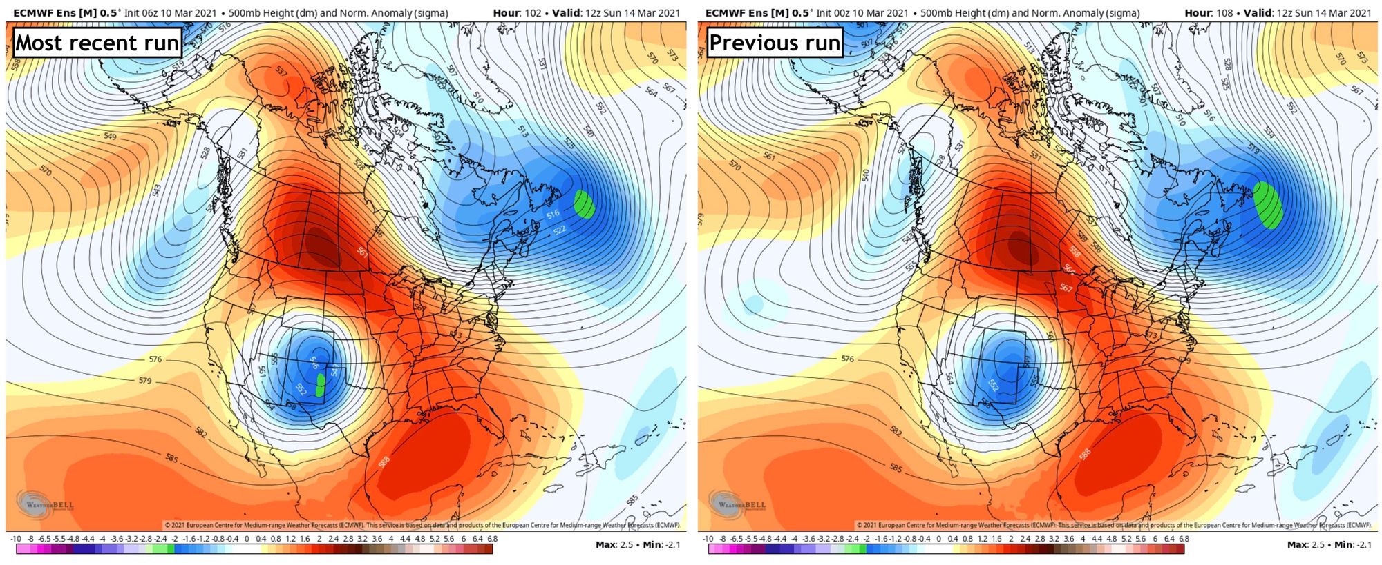
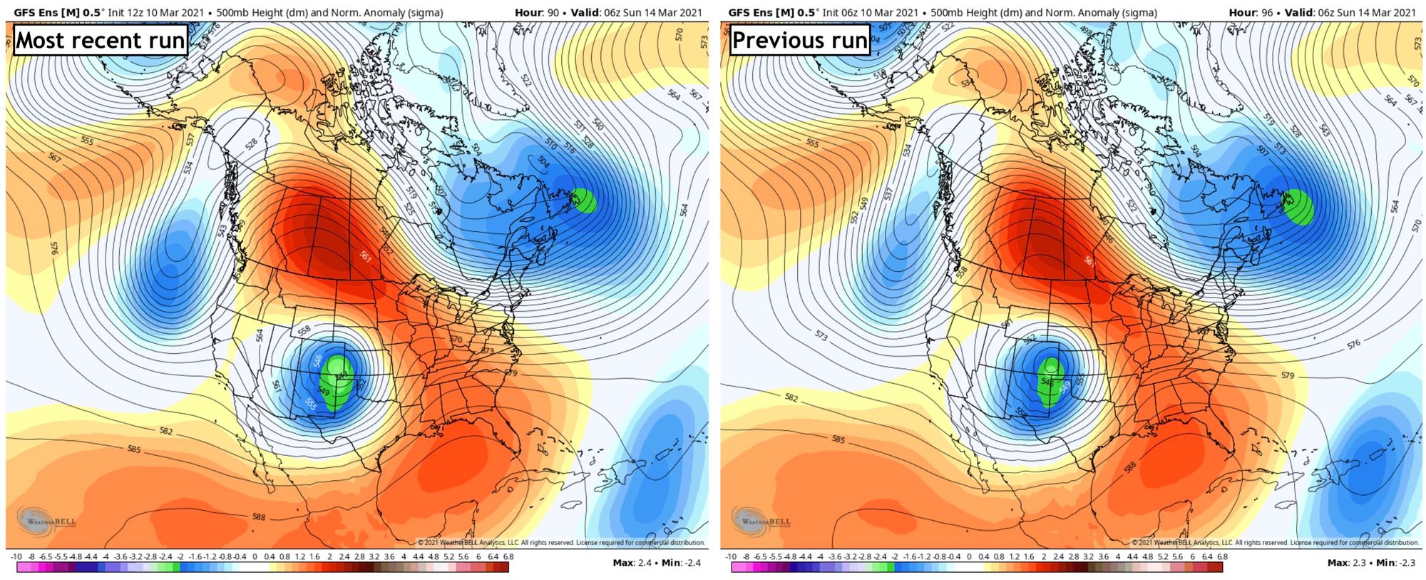
We will show three global models, American, Canadian and European and how each compares to their previous forecast. All are pretty consistent run to run, with slight difference between the models in track, intensity, and speed. These are all valid Sunday morning.
Euro 500mb comparison:
GEFS 500mb comparison:
GEM 500mb comparison:
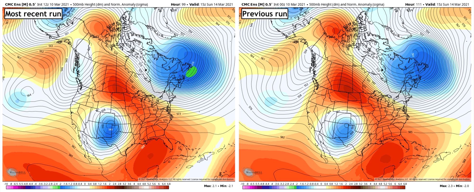
With only subtle shifts in that look at the storm, which remains in all cases at a 'sweet spot' for deep snowfall for Central and Northern Colorado (especially the foothills), Eastern Wyoming, and Nebraska.
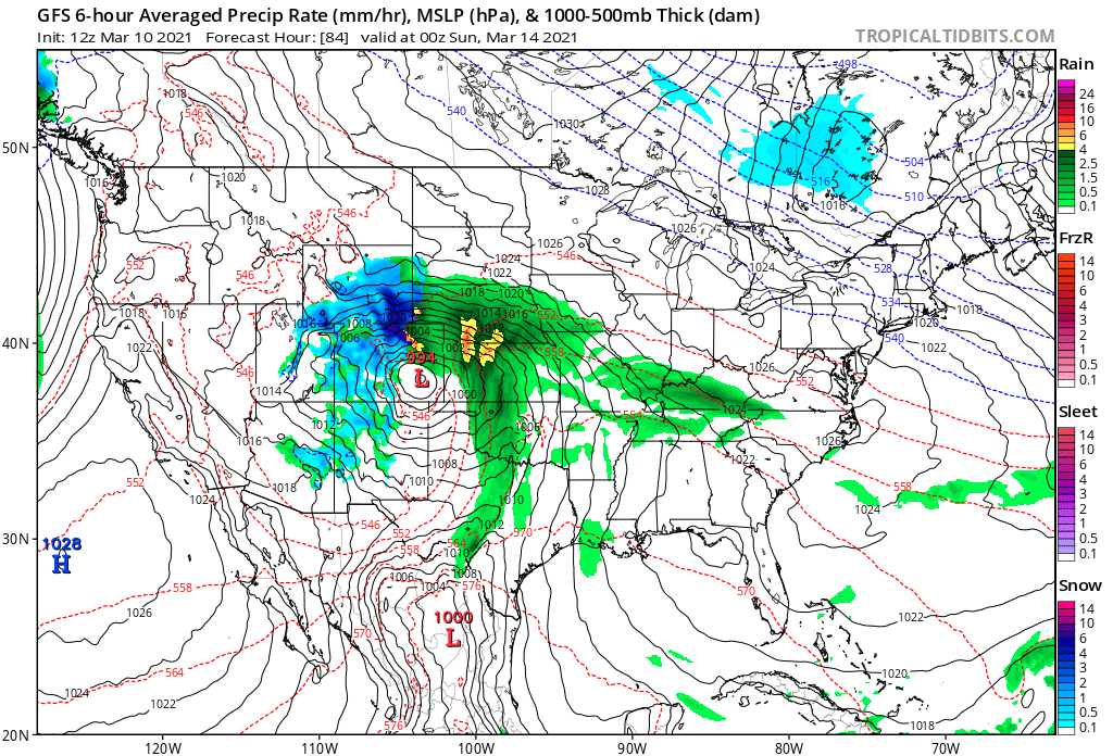
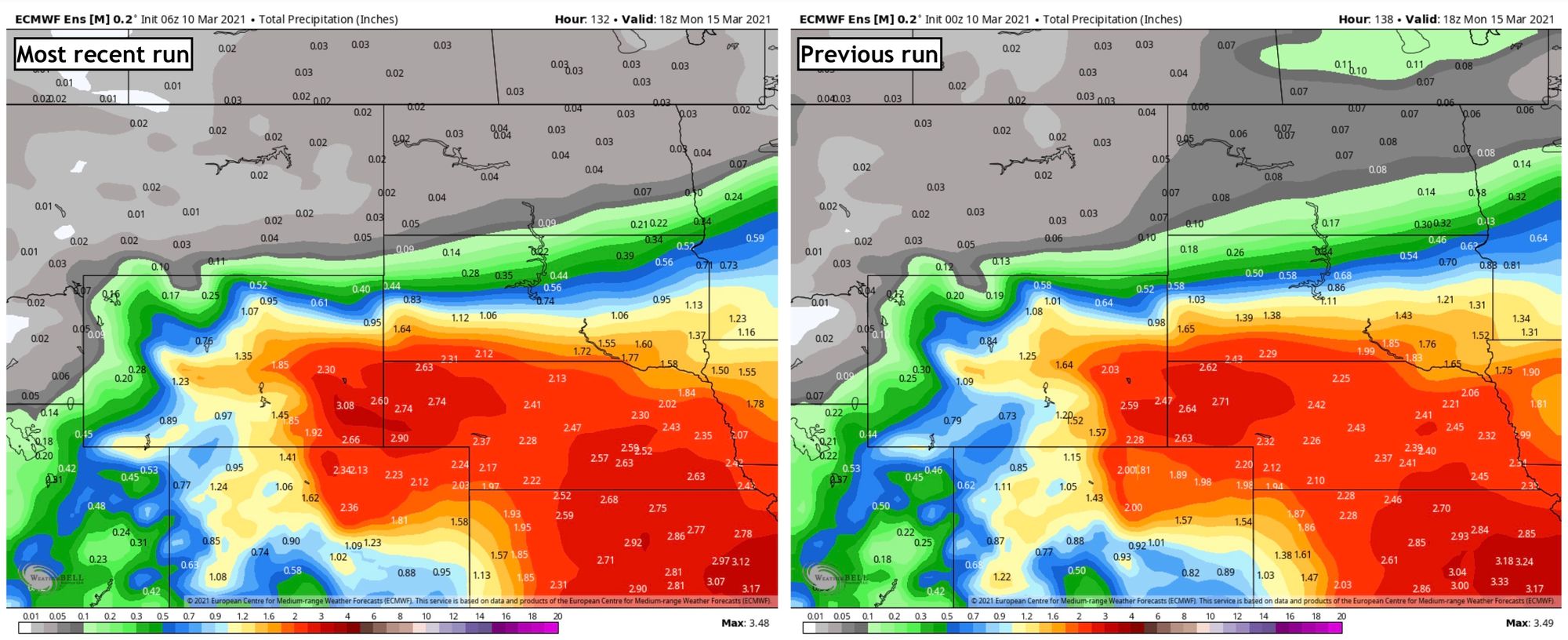
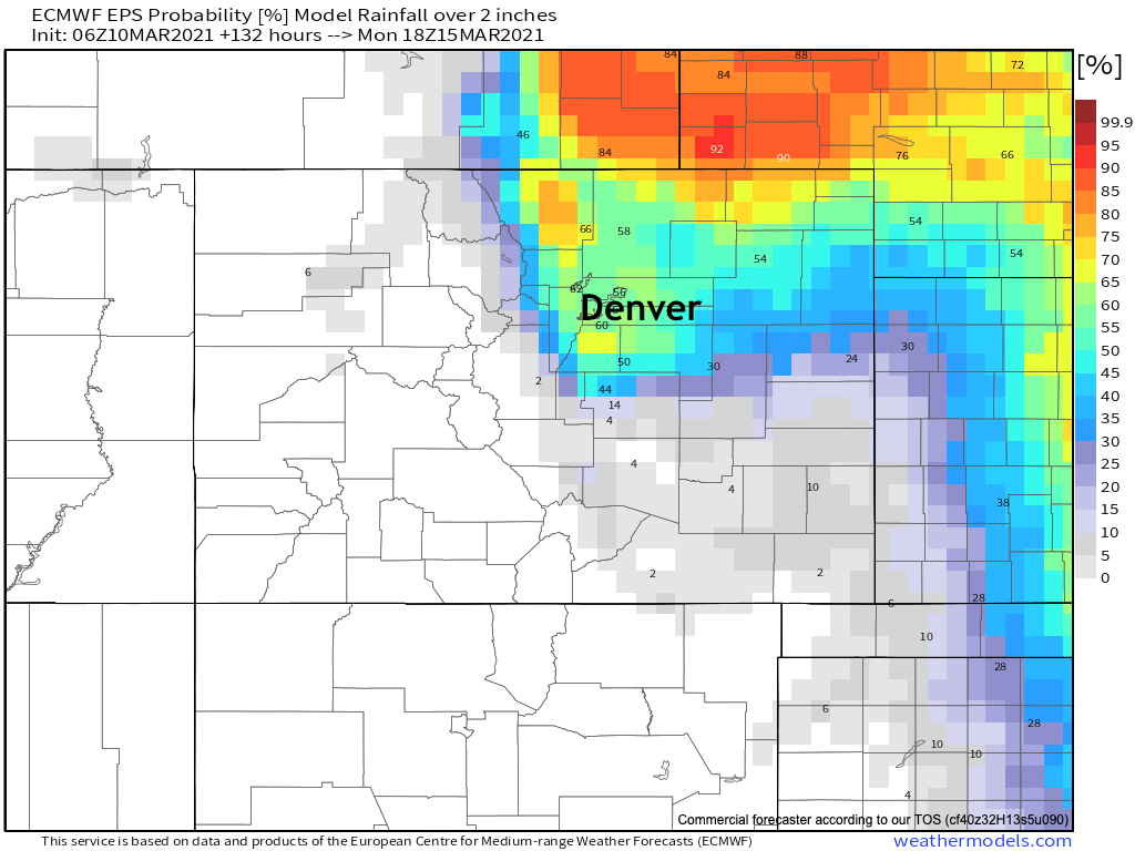
Let's look at the total precipitation that is possible this weekend. Again, a side-by-side comparison of the latest to previous updates. Pretty steady from the European ensemble at this point.
European precipitation forecast
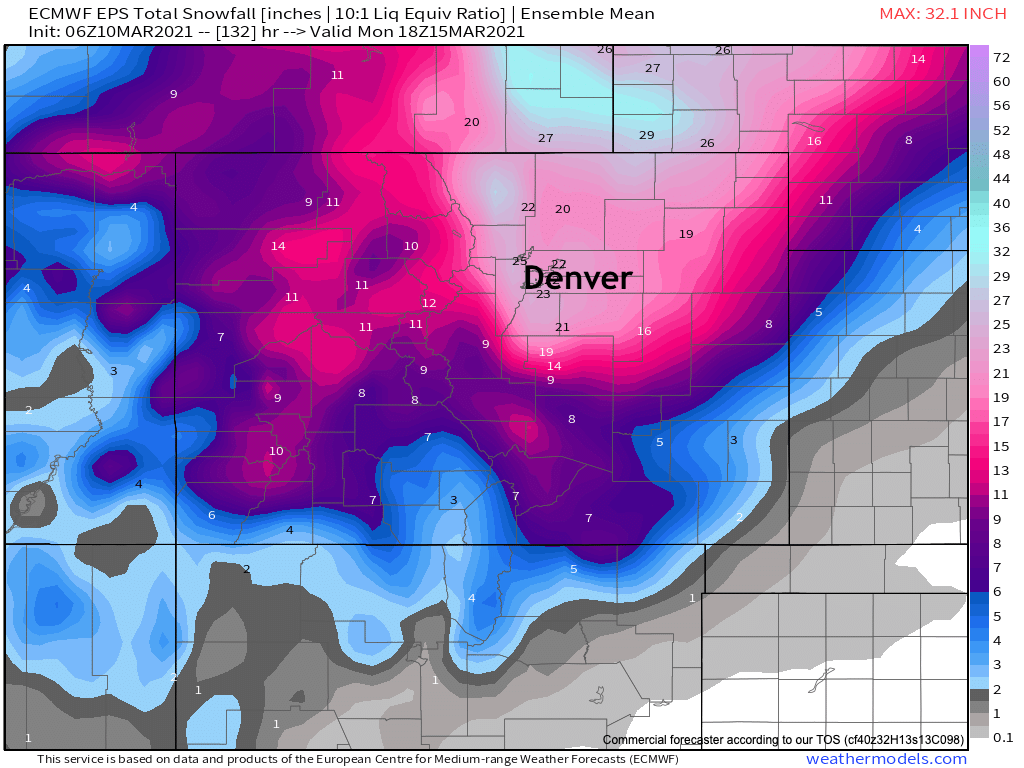
Modeled snowfall maps
We see little change, in a broad sense, to who will see the heaviest precipitation through the weekend. We will address some concerns with this precipitation forecast below in our summary section.
With any forecast, a big question also with this system will be snowfall ratios. Most maps you'll see online assume a 10:1 ratio – meaning, 10 inches of snow for every inch of liquid. We see a lot of discussion about ratios with this event being lower than 10:1, and while possible – we are going to lean toward higher end ratios at this time. The last system, also on the warm side, was quite impressive with snow production. We think average ratios for the foothills could end up higher than 10:1 and even 15:1, and for downtown Denver/DIA and east potentially lower than 10:1 - again, on average. Warm air, especially Saturday, could reduce snowfall accumulation due to rain initially for lower elevations, that is the most concerning aspect of the 12z GFS today, showing a LOT of warm air in the mix most of Saturday in Denver.
The European snowfall totals map (10:1) remains extremely consistent. We still question how much snow it has south of the Palmer, but a southern shift in track is still on the table, so that's okay. For Denver north, another model run with 20"+ for many spots and portions of the Foothills to our west seeing notably higher totals:
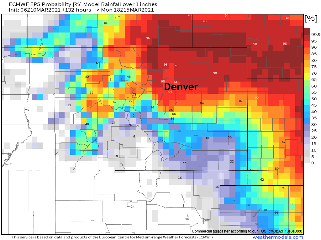
Probabilities
Let's take a look at the same Euro ensemble precipitation probabilities we've been showing you all week. What you'll continue to note is the northern emphasis – with odds for more than 1 inch of liquid a lower probability south of the Palmer Divide.
Here are odds of 1 inch of liquid or more through Monday morning:
Here are probabilities for 2" of liquid or more:
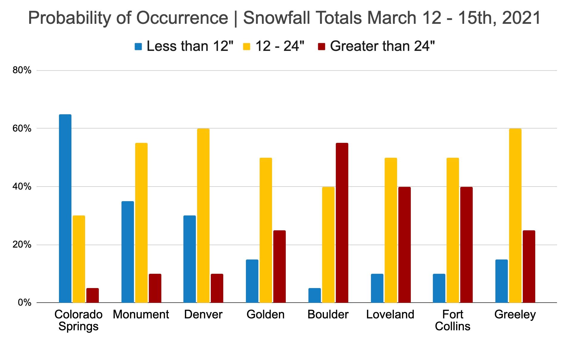
Based on those liquid amounts and applying some snow ratios, here are our latest snowfall probabilities for the region.
We're going with a better than 50% chance Boulder sees 2 feet of snow or more, with Denver's favored totals in the 12" to 24" range. Colorado Springs with the greatest low-end potential at this time.
What about the wind?
While much of this storm likely won't have a tremendous amount of wind, we are concerned that will change on Sunday. The animation below shows wind gust potential from late Saturday night through early Monday. The brighter yellows and reds indicate an uptick in stronger winds as we head into Sunday.
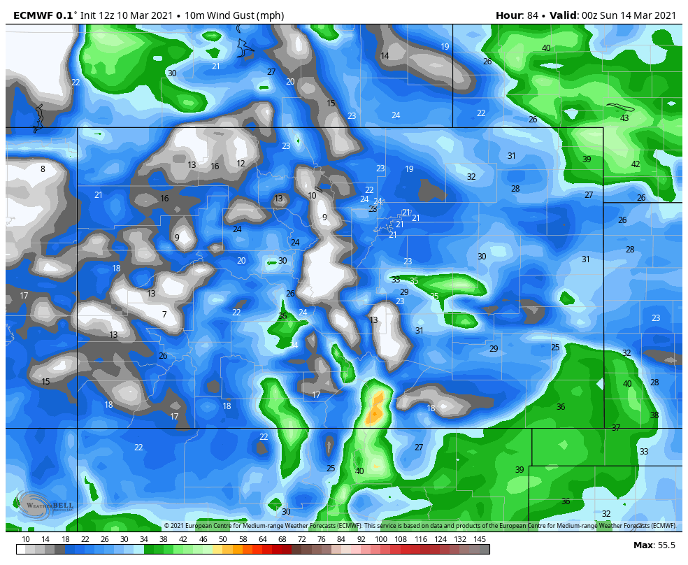
Notice how strong the wind gets along the Front Range, and especially across the Palmer Divide into El Paso County. Gusts over 50 mph are shown for El Paso County... That wind, coupled with falling snow and the snow that is on the ground would likely create blizzard conditions for those areas...especially, the Palmer Divide. Again, this would be mainly on Sunday, but wouldn't calm down until early Monday. IF this element of the forecast comes to fruition, travel would be pretty much impossible for those areas.
Yet another element to watch.
Lingering questions
We didn't see significant differences in the overnight and morning projections. A significant event remains forecast for this weekend.
Still several days away, we have some questions that remain about the storm.
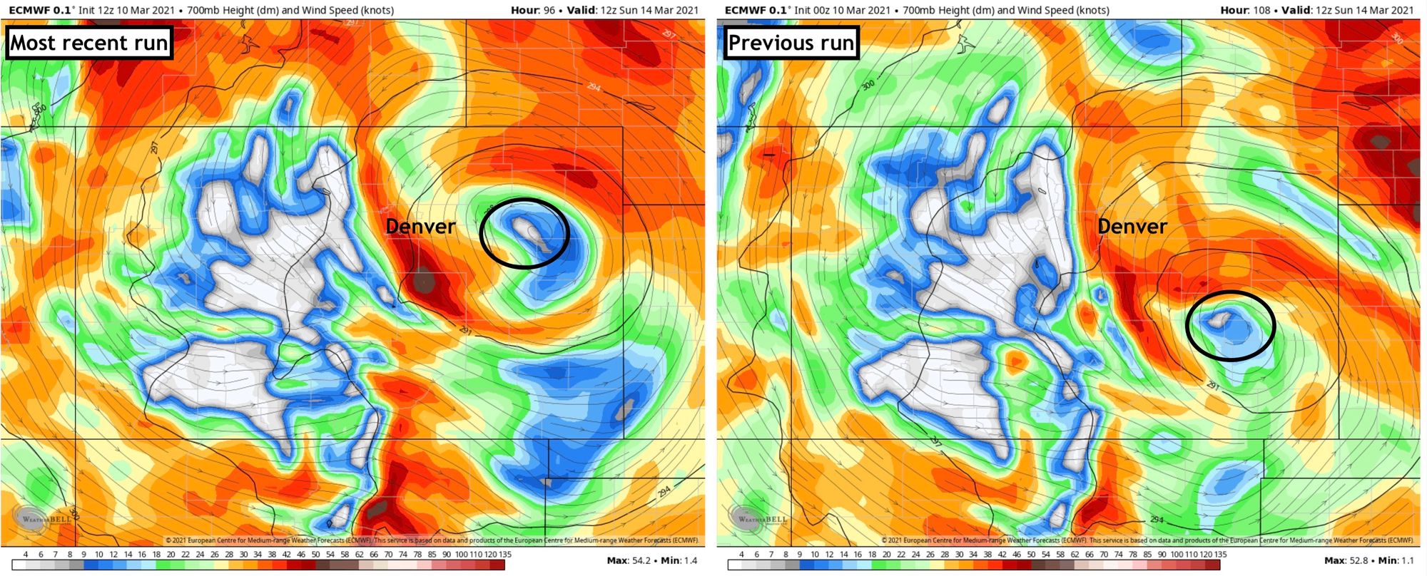
First, will the center of the storm continue to drift a bit farther north resulting in dry-slotting closer to Denver and a shift of heavier precipitation farther north? Anecdotally we feel models have a tendency to over-correct north, and then trend back south again as we get closer to these types of events. Let's see if that's true with this one. If this one drops south a bit more, that will confirm the deepest snow in Colorado's Central and Northern Front Range to Plains rather than pulling it north toward the border and into Wyoming/Nebraska.
We've been talking about "wobbling" a lot, and here's an example from the newest European that has just come in. It puts the 700mb low much further north Sunday morning than it's previous run. While we haven't seen this reflected in the ensemble means just yet, its an example of what could happen. It ultimately drops the low southeast, but with the track early on further north, it has lower totals this morning for Denver and the northern urban corridor than it did overnight. A trend? We'll see.
Second, will the system slow its speed once on the plains resulting in higher totals with longer period of heaviest snow? We still see difference between the modeling in how progressive this storm will be as it gets east of the Rockies. If it stalls, lookout for high-end totals.
Third, will warm air – especially early Saturday – keep rain around longer at lower elevations, and after that rain does change to snow will it keep snowfall ratios lower than our range for a significant portion of the event? This will greatly reduce that potential for high-end snowfall totals at lower elevations (Denver).
Fourth, will heavy rainfall from thunderstorms (potential severe weather) on the US plains in the warm part of the system take away from the total amount of precipitation available here locally?
Literally, all of these questions are tied to one thing... THE STORM TRACK AND EVOLUTION OF THE STORM. Any wiggle or wobble in the storm track will have HUGE implications as to who sees what. Why? Well, a small change in the movement or evolution of the storm, will change what happens with temperatures, moisture, wind profile, etc. Pretty much everything that is important in determining the eventual outcome of the storm, is tied to the storm track and evolution.
The uncertainty that goes along with forecasting the storm track will LIKELY decrease considerably in the next couple days. This will LIKELY go a along way in helping determine the finer details that are so important. However, this type of storm ALWAYS has late in the game curve balls that the models miss. So, we urge patience and preparedness, as we continue to figure things out and communicate with you.
Whew. More updates to come!