Thursday AM update: Storm track wobbles continue, latest probabilities for significant snowfall across northern Colorado

We continue to track a potentially significant snowfall event on the way for north-central and northeast Colorado this weekend. While widespread totals in excess of one foot of snow are possible, if even likely this weekend, there remain some caveats to that depending on exact storm track, which this morning remains in question.
As for timing, look for rain and show showers to continue off and on through Friday evening. These aren't expected to amount to much, but enough to feel unsettled at times across much of the state ahead of the main event this weekend.
By Friday night we see rain and snow chances increase, a trend that continues into Saturday and Saturday night. Taking an "average" of the various speed projections for this system, it looks like Saturday PM through Sunday morning will feature the best window for the heaviest snowfall along the urban corridor (even some thunder snow!) and Front Range foothills. Snowfall during this period could exceed 2" per hour, with the greatest snowfall rates expected in the foothills.
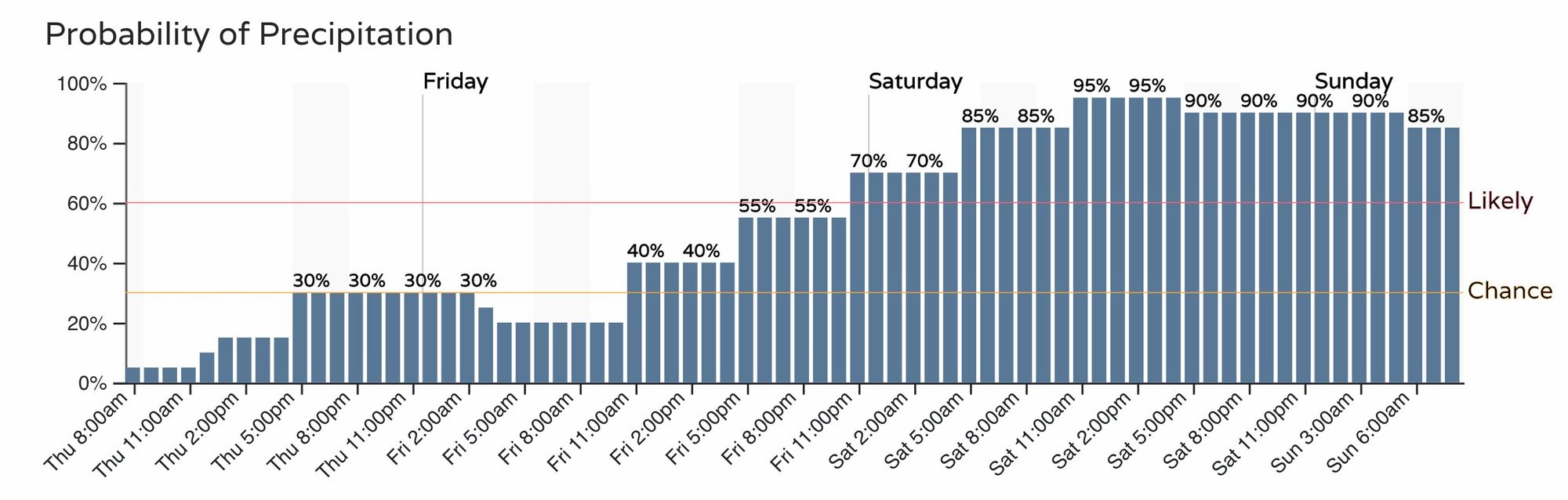
Below is a look at the hourly precipitation planner for Denver through early Sunday morning:
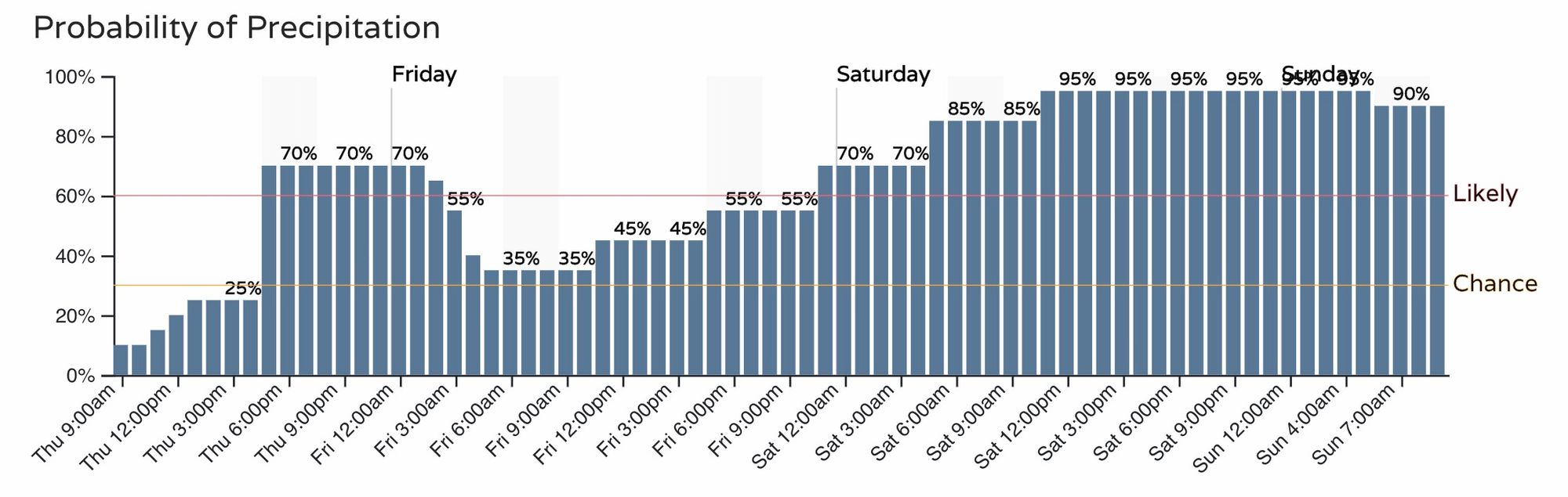
And for Fort Collins, we see a similar time table, but a better chance for those rain and show showers tonight. Some folks across far northern Colorado could see a quick Trace to 2" tonight, including the Fort Collins area.
Let's dive into this weekend's storm.
Quick highlights
- We continue to track the potential for a significant snow event across the urban corridor, Front Range foothills, and Northeast Plains.
- Who sees how much snow all comes down to storm track and speed – oh those pesky winds!
- We will continue to hug high-end probabilities for a high-end snowfall event this weekend.
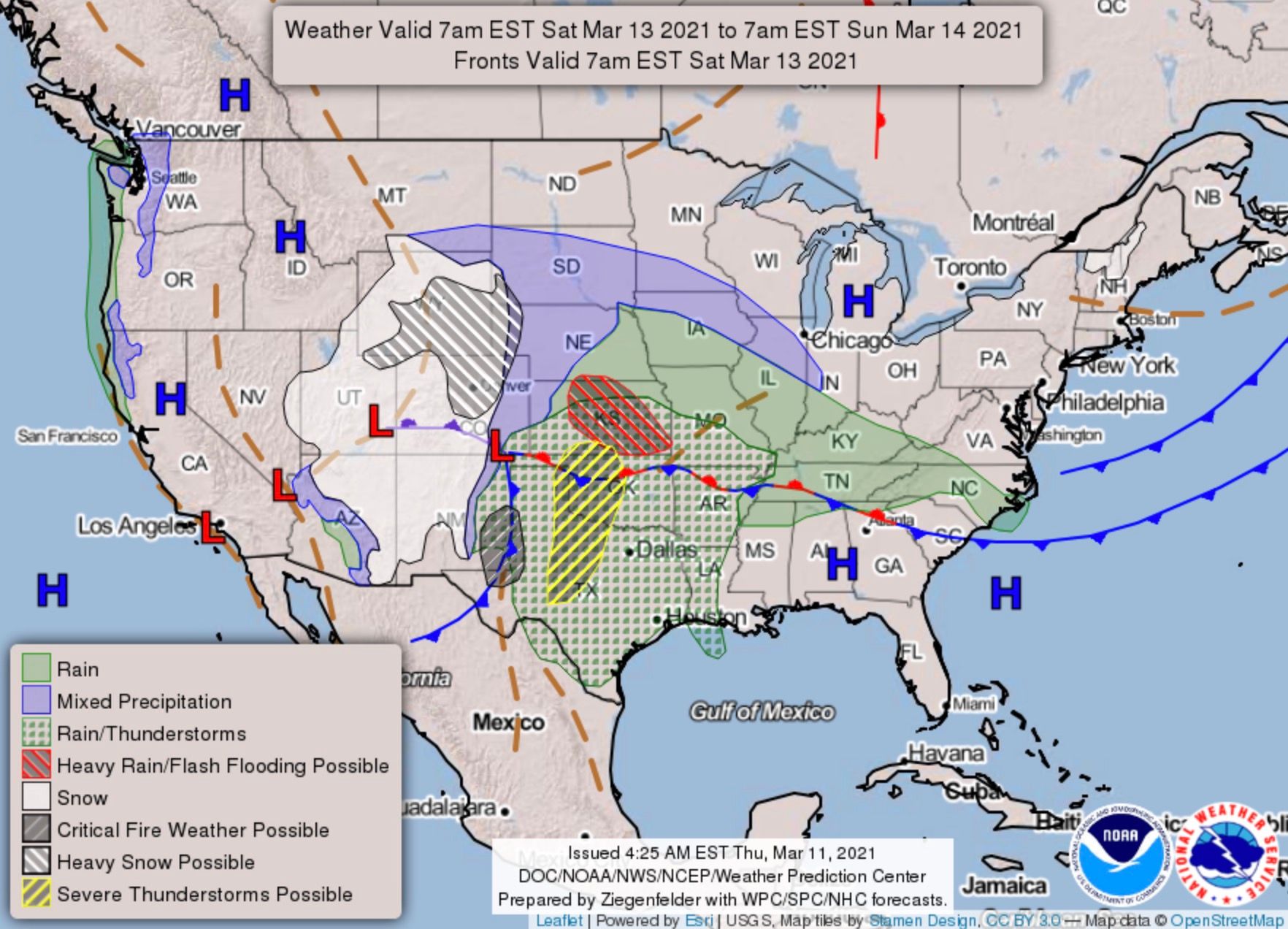
- A Winter Storm Watch is in place for all of Northeast Colorado, it runs as far south as Colorado Springs at this time. The Watch goes into effect Friday night and remains in effect through Sunday night. This will be a long duration event.
- More than a couple of ways this storm can still BUST, namely at this time is storm track.
- For the Denver Metro, temperatures may hover at or above freezing all day Saturday, before cooling down Saturday night. Given that it will be snowing during the day coupled with city warmth, there will be some melting of the initial snow that falls. For areas outside major cities (especially foothills) the snow should stack up pretty readily, and with plenty of energy around Thursday afternoon we could even see some thundersnow!
- Travel will be difficult, if not impossible for much of Northern Colorado, SE Wyoming, and Western Nebraska this weekend. Blizzard conditions likely for The Palmer Divide on Sunday.
Models
Weather models remain in split camps this morning, with some taking the low a bit further north, and others further south. The implications of the low tracking 100 miles north or south Saturday night/Sunday will mean the difference of a LOT of snow and well, less snow. The overall trend today has been back south, vs a more northerly trend we saw yesterday.
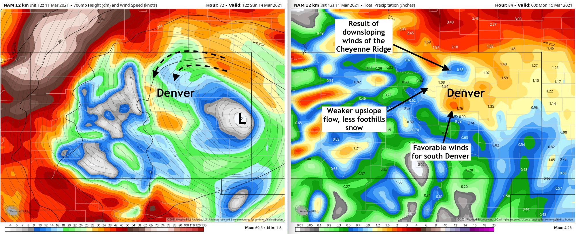
Let's take a look at two of the models for early Sunday morning and then their total precipitation and compare them.
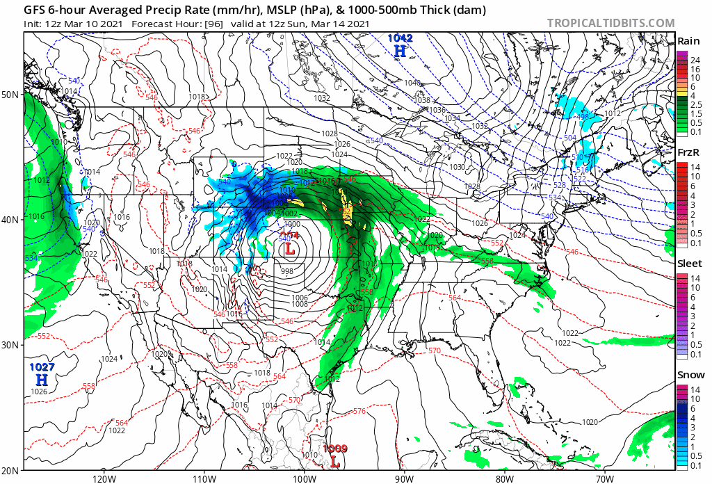
First, here's the 12km NAM. Sunday morning (bottom left) this model has the 700mb low over east-central Colorado. Winds with this track would not be all that favorable for the heavy snowfall you've been reading about all week – at least not for everyone. Winds here wrap around and end up pretty northerly up agains the Front Range. This would equate to downsloping off the Cheyenne Ridge (see the image on the right), less snowfall for the Foothills, and perhaps a "boom" snowfall on the south side of Denver. The scenario would keep totals mostly in the 8 - 16" range, with lower totals up north for the Fort Collins area.
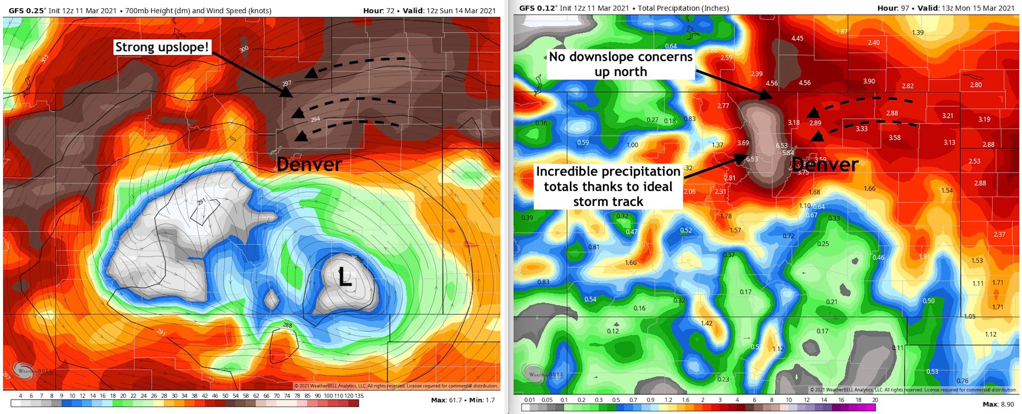
Now if we contrast that to the 12z GFS (which by the way has trended back south!) we see the low at the same time Sunday morning as about 100 miles southwest of where the NAM has it. This not only puts easterly winds right into the northern Front Range, but also much stronger upslope flow as well with more of the energy further south. THIS is the setup you want if you're hoping for a big time snow this weekend. The GFS has been absolutely nuts with moisture this week, and while the numbers indicated below might be out of reach – it shows very well where we'd expect the heaviest snow (multiple feet!) if this is the favored track. This particular solution would support 1 - 3 feet for Denver/Loveland/Fort Collins with likely some 4 to 5 foot totals in the foothills.
We aren't certain which track ultimately pan out, or if we even see more wobbles in the data than indicated today. What we will say, we feel a more southerly track will ultimately be favored, which gives us greater confidence in the high-end potential with this setup.
To that point, take a look at the last six runs from the GFS. All valid the same time Sunday morning. A clear trend in this model anyway to pull that low south and west. The first image has the low out in east Kansas, then it slowly backs west then south. Does this trend hold? Do other models follow? We'll see. The NAM is still pretty far north and east as we showed above, but not AS far north and east as it was last night.
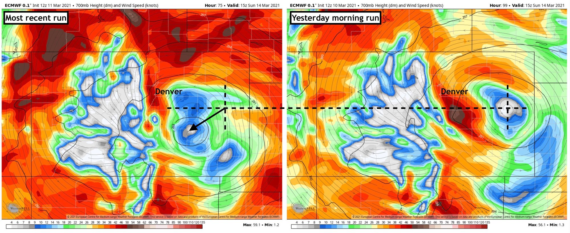
And, more of a "wobble" but still a notable one, even the Euro has come a bit further south and west with its 700mb low Sunday. The most recent image (left) shows where it is located in this morning's data – a pretty great spot for folks from Castle Rock north along the Front Range to see a good amount of snow.
The whole point is, this still isn't a done deal, and hopefully this should help demonstrate how easy it'll be to go from a big time, potentially record snow, to a nice storm but a "bust" in most people's eyes. For now, if you want a big snow, the trend is your friend – let's see if that holds.
Ensembles
For those that have followed us for awhile, you know we preach ensembles vs using any single deterministic model run. Ensembles are the same model run many times with slightly different initializations.
So, is the ensemble support for this weekend's snow?
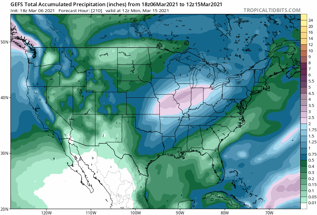
The operational GFS, as crazy as it's been, actually has pretty darn good support from its ensemble – which has trended wetter and wetter over recent days. Below is an animation of precipitation totals forecast by the GEFS valid Monday morning. You'll note the Front Range progressively getting wetter, with more and more purples showing up – indicating the MEAN precipitation total from this model is more than 2" across the entire region, and upwards of 3" for the foothills! Taken at face value (and assuming all snow) this would indicate widespread totals of 2 - 3 feet, with locally higher in the foothills.
Probabilities
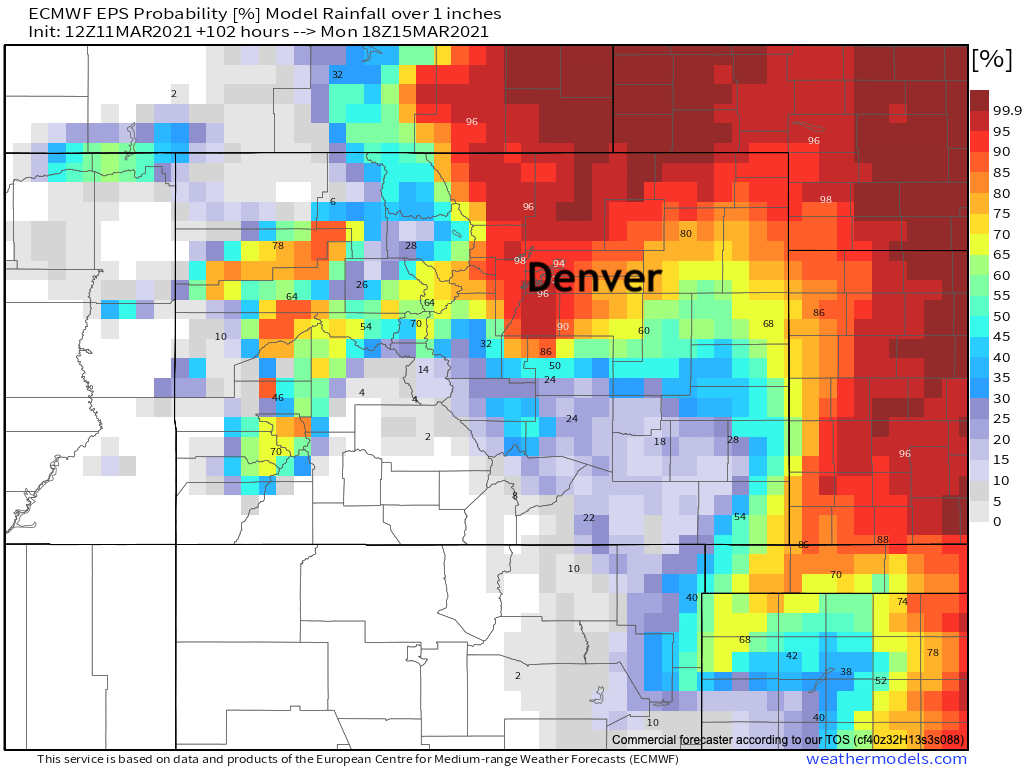
Here are the latest probabilities from the European ensemble model for 1" of liquid or more through Monday morning:
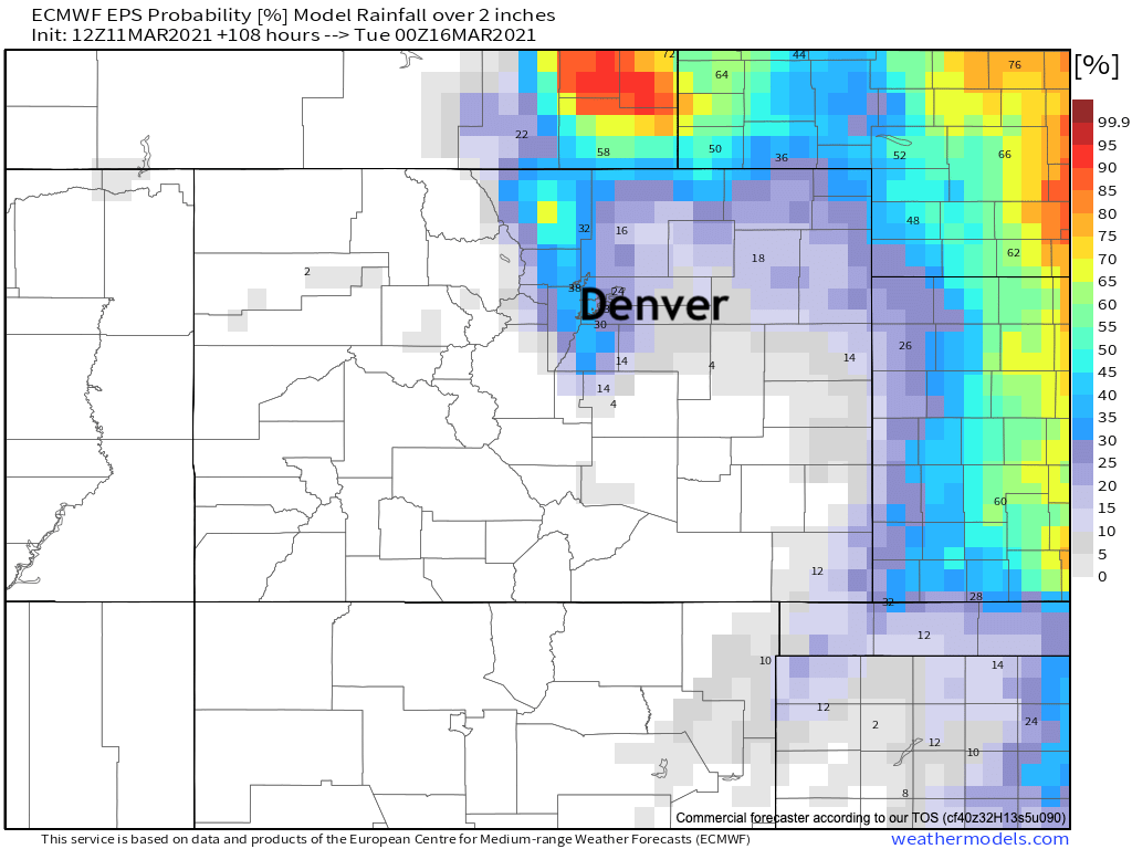
And here is for 2" of liquid or more, which is actually down notably from its 2" probabilities yesterday. Concerning? Maybe. We'll see if the ensemble is just lagging the operational models in shifting south/west or not.
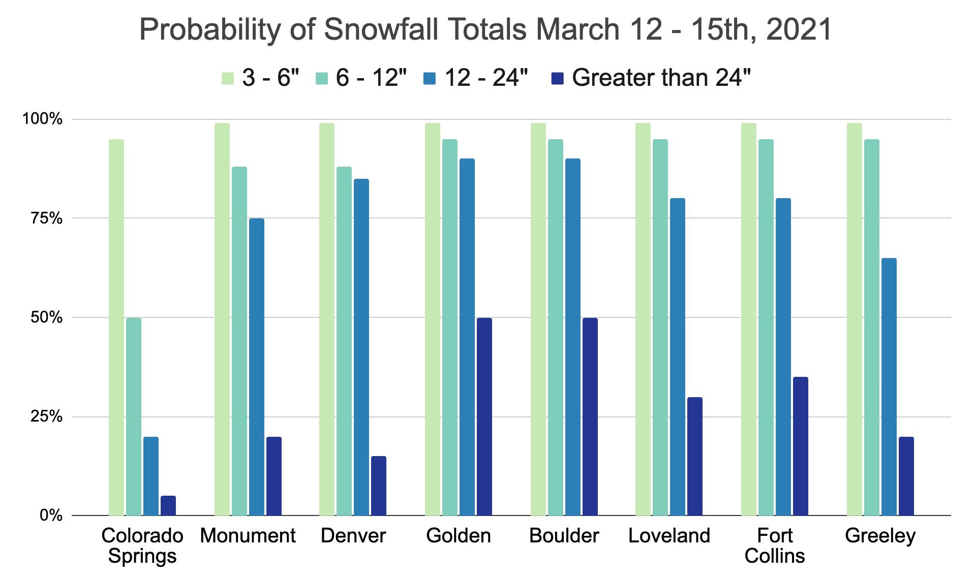
And here are our latest snowfall probabilities for select Front Range cities:
Snowfall forecast
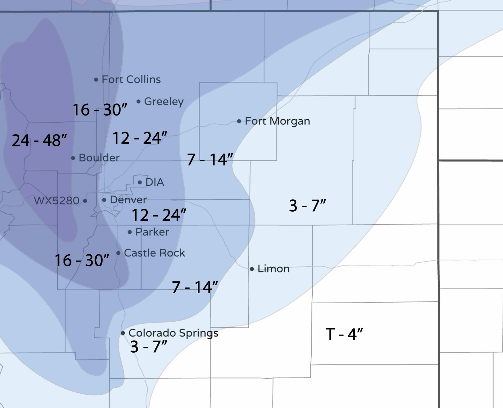
Finally, here are our initial numbers. Yes, we know the ranges are LARGE, but there's a lot of uncertainty. This should be a good starting point, and we'll adjust in future updates. A lot of potential with this system, but remember the probabilities and still unsolved "bust" concerns we have.
More updates to come, thanks for following along, and please subscribe to stay up to date!