
Saturday evening storm update

I don't really know where to start tonight, so let's start with the the question I've been asked about 300 times today: Am I worried about our forecast?
The answer is yes!
But here's the thing, anyone that knows me knows it's ALWAYS a yes. I worry about every forecast probably way more than I should. I've been worried about this one since we started tracking it over a week ago. I worry when we forecast 1 - 3" and darn nobody cares.
My quick hot take from today is something like the following.
People either don't understand probability, don't appreciate that predicting the future is hard, don't understand that over the course of a 48 hour Winter Storm Warning all the snow won't fall in the first 5 minutes, don't read this site (😁), or are put on this earth purely to make others around them feel as small as possible. In reality it seems like a kind of gross cocktail of all of the above!
I can assure you, no one takes busted forecasts harder than all of the many meteorologists who put an unbelievable amount of time into putting together said forecasts to help the public stay aware and safe. Coloradans are fortunate to have some of the brightest minds in the field living right here along the Front Range, and the number of hours that went in to tracking, analyzing, writing, discussing, graphic-generating, and communicating this particular storm over the last week was no small amount.
So, kudos to all of our friends at the National Weather Service, BoulderCast, HighPointWx, the numerous TV outlets (local and national), and the many other mets working in the public or private sector that helped track this storm and communicate its potential all week and this weekend.
Now to the other question at hand. IS this storm in fact a bust?
The first thing I would say is we just don't know yet. If there's anything any of us who live here should know about the weather in Colorado, it's not over until its over. And it's just not over yet.
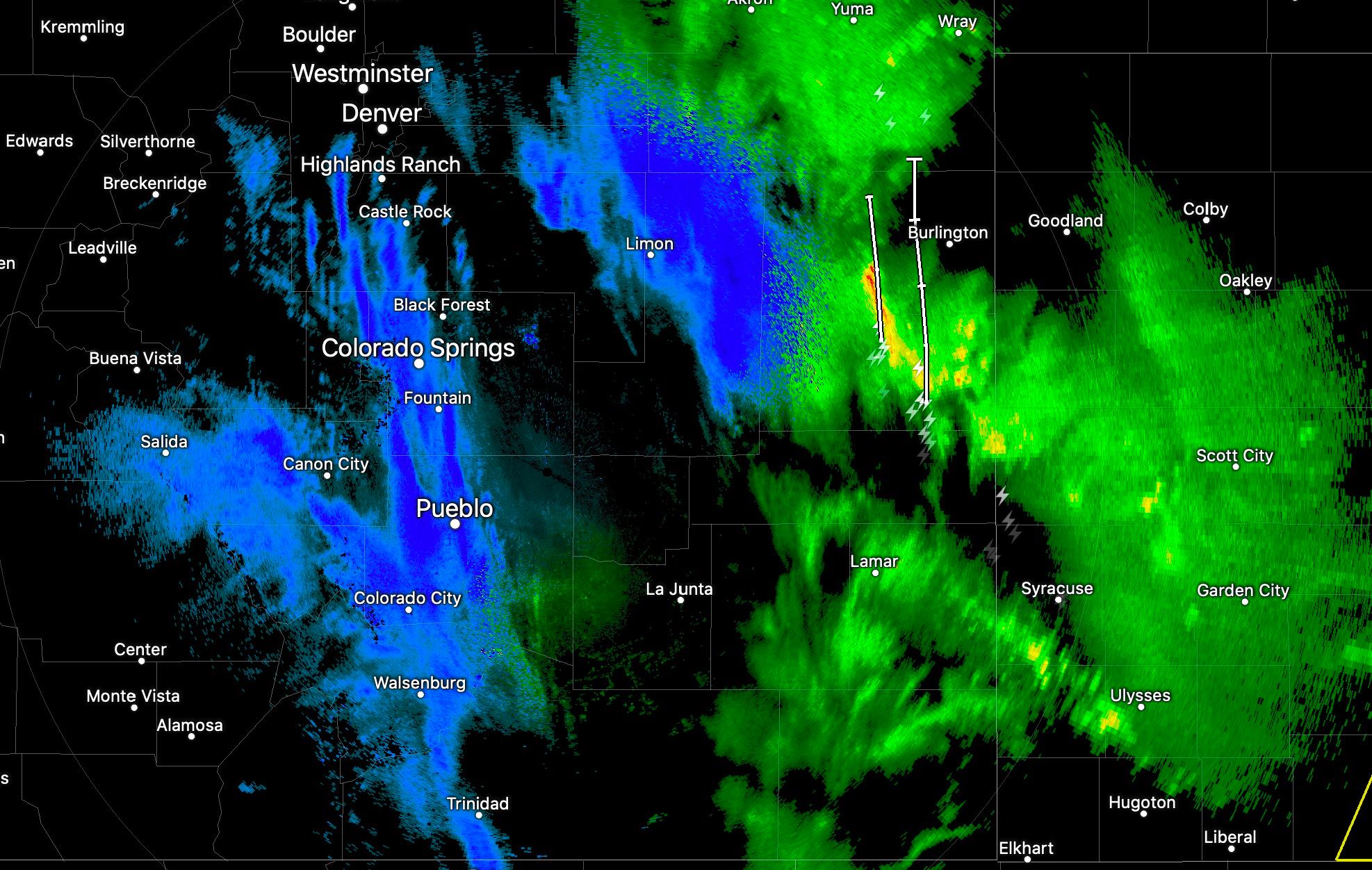
There have clearly been some issues so far. Namely, we hope, with timing. But a significant amount of dry air worked into the system today, there's been a lot of daytime melting, and a significant severe outbreak to our southeast may have hurt numbers more than we yet know.
After virtually not moving much of the day, the low is on the move tonight. It's centered east of the Four Corners now, and will continue to slowly track east through the day Sunday.

As it does, we anticipate a period of better sustained snow, and if we can finally get some good upslope going we can turn this whole thing around.
This from the National Weather Service in Boulder this evening helps explain what's going on:
However the more important element will be the winds through the atmosphere. The 500mb low is currently over northwestern New Mexico, starting to be in a favorable position to bring the Front Range upslope flow. Except the associated through is stretched/shaped just so that winds above 650 mb are south-southeasterly, shown nicely on the sounding and KFTG VAD wind profiler. This is not particularly great in upward forcing from upslope. As the 500 mb low continues to move east overnight, the winds throughout the atmosphere will begin turning out of the east, to start the “true” upslope flow and get snowfall rates cranking. Just within the last 30 minutes, VAD winds are beginning to back slightly, and current radar echoes are starting to light up along the Front Range, signifying better upslope flow.
Even as we in the midst of yet another lull in the action this evening across the urban corridor, we are tracking another push of moisture headed our way from the south and east, it should arrive in the next hour or so.
If we look at some of the short term models, most of them insist the snow will arrive. At some point.
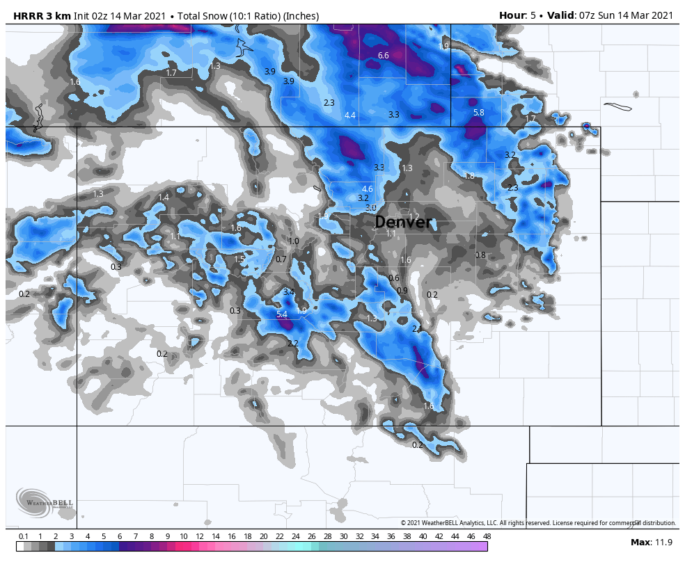
Here's the HRRR through about midnight. It shows only about 1" for the Denver area, but 3 - 6" for areas along and west of I-25 north of Denver (perhaps some of that from the most recent band of heavier snow that moved through).
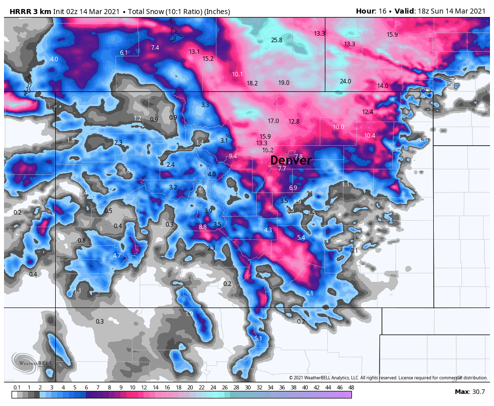
By mid to late morning it's got close to 16" for Boulder, and 6 - 10" for Denver. That would imply some serious snowfall after midnight tonight, especially from Denver north to to Wyoming.
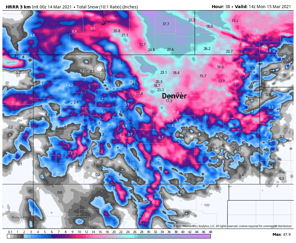
The most recent extended run of the model from 3 hours hours ago showed the following by Monday morning – with most areas in the 18 - 24" range along the urban corridor.
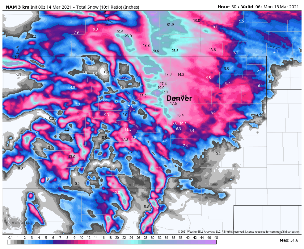
The 0z 3km NAM also remains bullish on snow. Some of this falls in the next couple of hours (which is concerning given current radar), but once we establish better upslope the radar should look better in a hurry. This model continues to show from 15 - 20" for the urban corridor, and of course several feet for many foothill communities:
So, are these models flat wrong? Are we flat wrong with our forecast? The answer is absolutely maybe. But given we have had about a million people call this storm finished before it even started, I vote we let the remainder of the weekend play out and then evaluate how things went.
As for totals so far... we've picked up 3" in Denver West. About 1" from the heavy showers that moved through midday, and another 2" this evening before this latest lull. We've seen reports that DIA has already picked up about 5" of snow, which would make sense given a pretty active radar out east today. Wouldn't that be something if DIA was the only spot that verified? Hah! As for other locations, help us out – how much have you seen? I just saw are report from Boulder at about 4.5", and 6.5" in Fort Collins, so in a few places we are starting to get something worth measuring.
So, from a purely, "how am feeling" standpoint, the answer is not amazing. It certainly FEELS bad. But I just don't think we've seen the last of this system, and if we are to believe observations, the latest data, and ourselves by the way, the best snow has been delayed, not denied.
The lull we're tracking now should be replaced by another round of snow in the next hour or so, let's see if we can get something a bit more sustained going as we move past midnight and into Sunday.
Hoping to visit with you all in the morning with an entirely different outlook on things!
Keep the comments rolling in, we enjoy the interaction and love the storm reports.
Let it snow!