Ever Hear About The Atlantic El Niño?

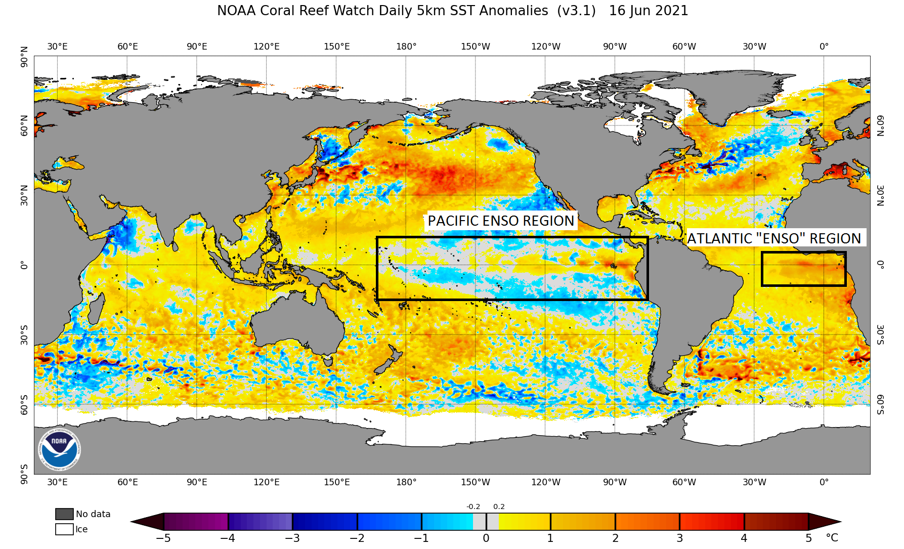
Yep, it's true... The Atlantic Ocean has its own version of El Niño. It isn't quite the global influencer that the bigger Pacific El Niño is... However, it has been researched enough to provide somewhat of "a tell" about what phase the Pacific ENSO may develop into. First off, where does the Atlantic El Niño occur?

The map above shows the warmer than average sea surface temperatures in the Gulf of Guinea...just off the west coast of Africa. This "ENSO region" is much smaller than the Pacific ENSO region. Just like the Pacific, the Atlantic can also exhibit warmer than average and cooler than average sea surface temperatures within its "ENSO region". So, what is it about the Atlantic "ENSO region" that can tell us what the Pacific ENSO region will do? Well, when the Atlantic "ENSO region" is exhibiting cooler than average sea surface temperatures in the summer and this signal persists throughout the summer, it weakens western Pacific trade winds and triggers subsequent tropical Pacific warming (El Niño) through a positive feedback of atmosphere-ocean interactions (Y. Chikamoto, Z. F. Johnson, S.-Y. Simon Wang, M. J. McPhaden, T. Mochizuki). Consequently, when the Atlantic "ENSO region" is exhibiting warmer than average sea surface temperatures in the summer and this signal persists throughout the summer, it strengthens western Pacific trade winds and triggers subsequent tropical Pacific cooling (La Niña) through a positive feedback of atmosphere-ocean interactions. This "tell" usually comes full circle in the Pacific about 7 months after it is exhibited in the Atlantic. The importance of this is obvious... Through better understanding and modeling of the Atlantic, we can better understand the influence it has on the Pacific and give us better lead time on Pacific ENSO phase development.
Here again is the map I posted earlier...

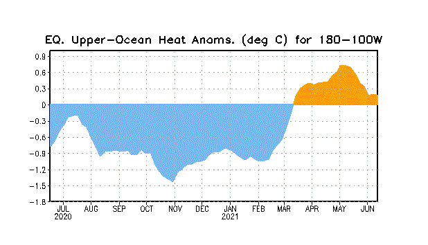
Right now, the Atlantic "ENSO region" is moderately warmer than average and we are half way through June. Given the the time of year, and that magnitude of the anomaly, it will likely stay warmer than average through the rest of summer before cooling later this year. Right now, the Pacific ENSO region is largely neutral with some cool and warm anomalies...nothing significant. And while upper oceanic heat anomalies were positive this spring, it has effectively returned to zero as of late. Again, indicating neutral Pacific ENSO conditions...
Now, based on what we've talked about, and given the current Atlantic setup and past history, it would suggest a return to La Niña by late summer and fall.
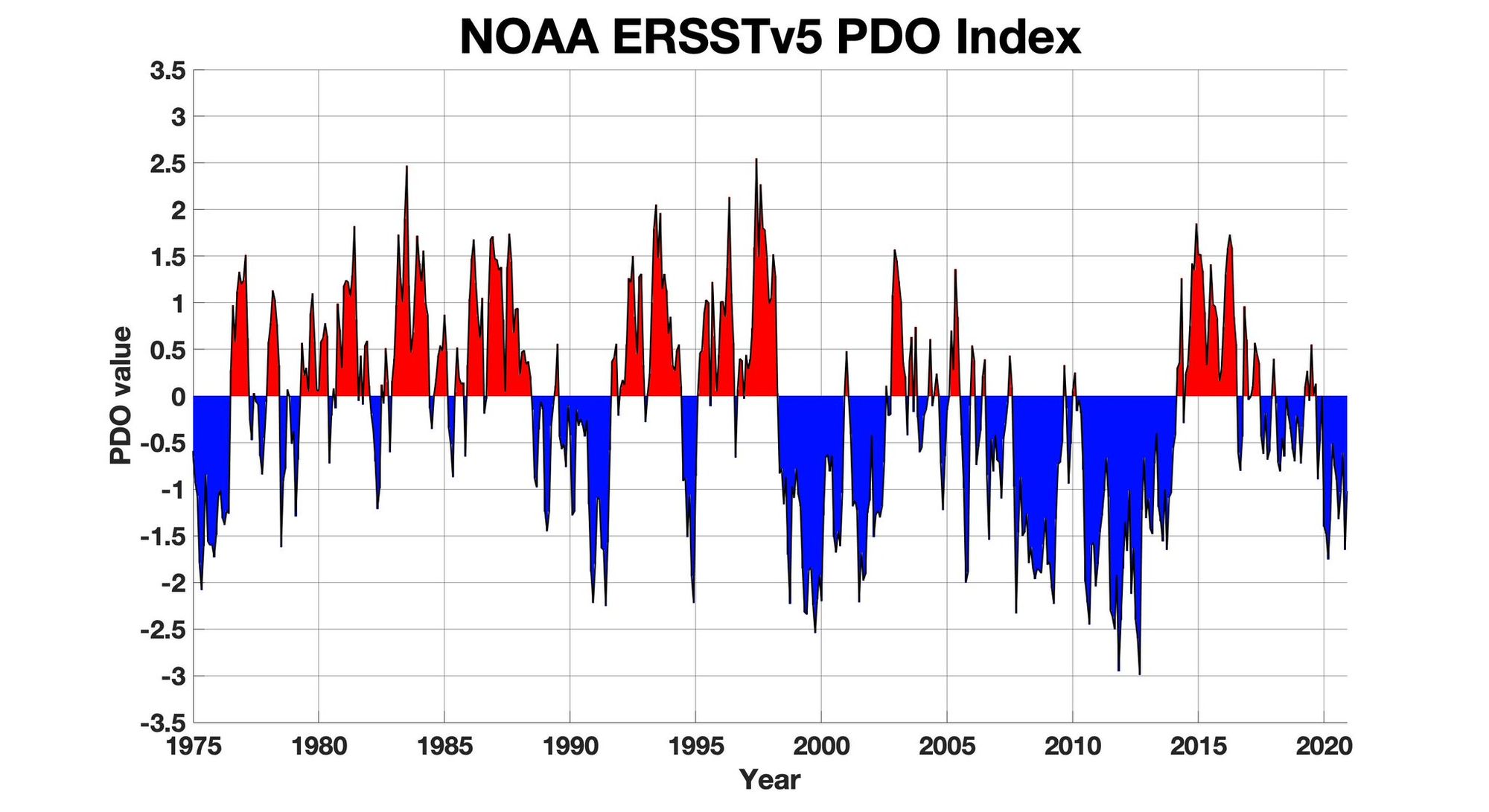
Let's look at something else in the Pacific...the Pacific Decadal Oscillation. Right now, the PDO is not just in a negative/cool phase, it is the most negative/cool it has been since September of 2012. Typically, a negative/cool PDO favors more frequent and sometimes stronger La Niña development. The following chart show the PDO since 1975...
What are the models suggesting? Well, as we move past the "spring predictability barrier" of the long range models, predicting what phase the Pacific ENSO moves into will be "easier" for the models. That still doesn't necessarily guarantee that they know what they are talking about, but it should give us a better idea.
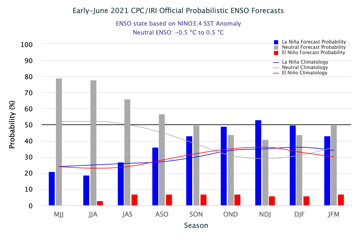
The above probabilistic ENSO forecast clearly shows a greater likelihood to return to La Niña by late summer and fall. In fact, there is a greater than 50% chance we enter into La Niña in the November/December/January time frame. I think this may even be a little underdone. Some of the individual long range models are suggesting the potential for a strong La Niña episode too. While it is too early to make that type of a forecast, I think it is a pretty good bet that we have at least a weak to moderate event.
A lot to digest here... While you are doing that, I will be crafting a post that shows the latest long range models and what they are projecting for the rest of the year.