The State of the Atmosphere: Sunday, February 6th, 2022

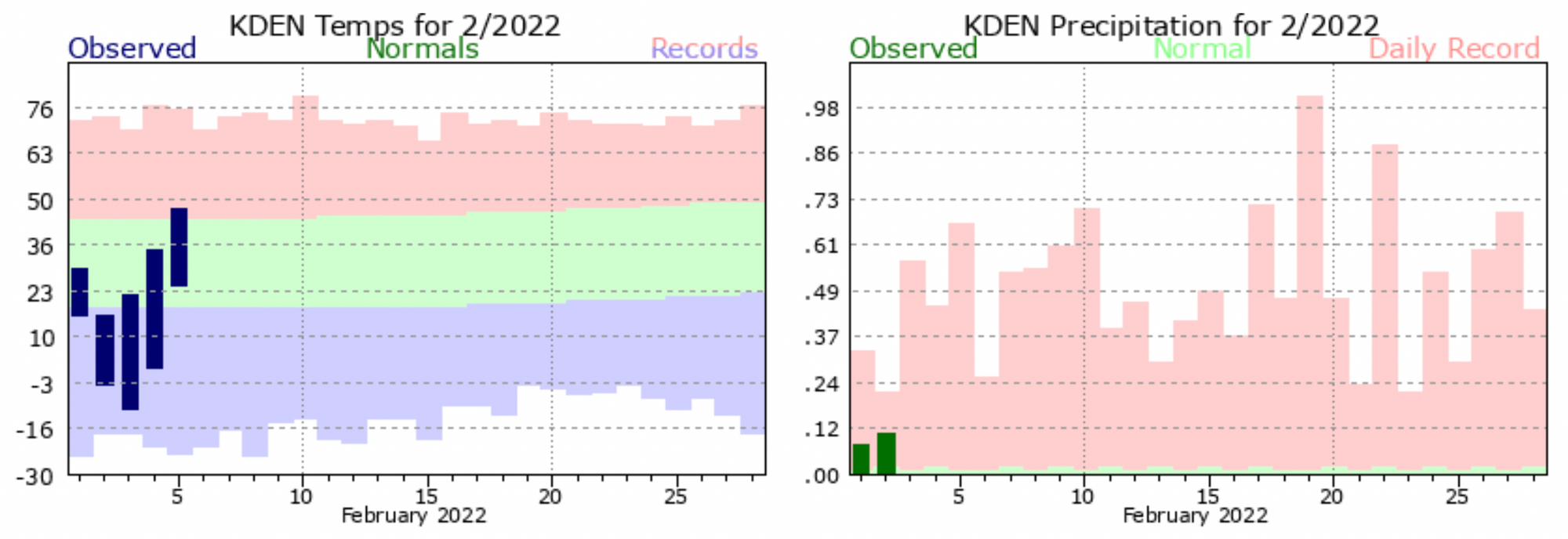
Denver's snowfall total from last week's system climbed a bit from our initial totals report, with DIA ultimately picking up 3.5" of snow. This brings the airport in range for our forecast, but... still greatly misrepresents how big a storm this was for most of the Denver area.
Year-to-date Denver (DIA) has now picked up 21.7" of snow, which is roughly 6.0" below where we should be in early February. By the end of the month the seasonal average in Denver is 34.7", so while we're off to a great start – we have our work cut out for us if we're going to approach average by month's end.
The start of the month has also been extremely cold. Through the first five days of the month the average temperature in Denver was just 17.7°F, a chilly 13.3°F below average for the period.
For the week ahead we expect temperatures to moderate a bit, with no extreme cold showing up despite the chance for a couple of systems to bring some impact the state through next weekend.
The GEFS ensemble shows highs around 50°F most afternoons, warmest on Friday. Other models suggest mid to upper 40s, with Friday being the only +50°F day, and if Friday night's system pans out, the 49°F indicated here will be too warm for sure. The average high for this time of year is in the mid 40s.
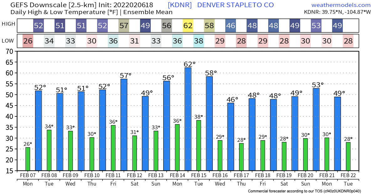
Even if next weekend ends up colder, the general idea holds. No single digit highs/below zero lows in the forecast this week, and perhaps not beyond that either if the GEFS is correct.
If we look at the 500mb pattern as advertised by the European ensemble model over the next week, you'll note a couple of things. First, is the lack of any blues over Colorado (storminess), and the second is strong ridging (deep reds) showing up in many if not most of the frames off the West Coast, and at times even centered a bit inland.
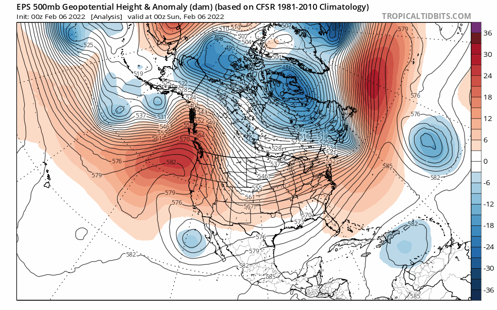
This is indicative of a largely quiet or at least warmer pattern around here, and for much of the West. Still, the predominantly northwesterly flow aloft means those of us along the Front Range can't sleep on things either, as we've seen time and again over the last month systems that don't look like much on the large-scale, can still kick a quick cool down and snowfall for us along the urban corridor and Front Range.
Looking at 2-meter temperature anomalies from the GEFS over the next week, we see all that above average warmth flooding the system after last week's cold, with what cold we do see generally focused east:

As for snow chances around here... it looks like we'll have two chance over the next seven days even if both chances are highly questionable at this time.
The first will come Wednesday into Thursday, and the second Friday into Saturday.
The first we can almost go ahead and call a non-event, but let's get into the week before we do so officially. Models show a bit of rain and snow shower activity flying through the state Wednesday afternoon/night, but the trend has been a drying one, and it's hard at this point to find much data to support anything meaningful.
The latter week system there's a split between the GFS and European models, with the GFS producing a bit stronger of a wave and showing more moisture availability and the Euro (currently) showing another non-event. Even in the case of the GFS it looks like it would favor the foothills/western Palmer Divide for snowfall vs the bulk of the Denver metro and east (think several systems in January), but it's too early to be sure of anything at this point.
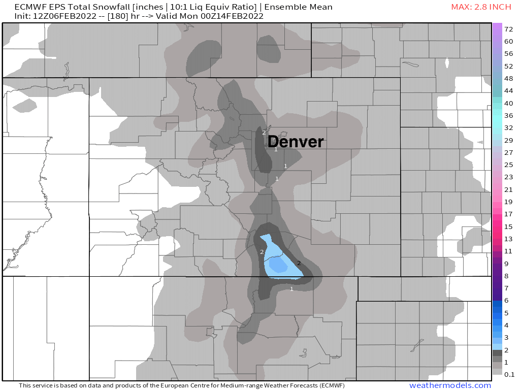
What's for sure is our snowfall gamblers aren't all that excited about any upcoming snow chances:

With the Euro ensemble meaning producing a rather unconvincing 1 - 2" across the area through next weekend:
Key takeaways?
Don't sleep on the northwest flow, but do sleep well knowing even with a couple of systems to watch this week, the overall pattern in a milder one with plenty of sunshine most afternoons.