First thunder of the year possible as weather turns colder and wetter for the weekend

Both a fun forecast and not terribly fun-to-forecast forecast on the way today as we replace our early season warmth with chillier and wetter weather for the weekend.
In true Colorado fashion, this weekend will feature just about everything – from rain, to snow, to graupel, to possibly our first thunder of the season as well today.
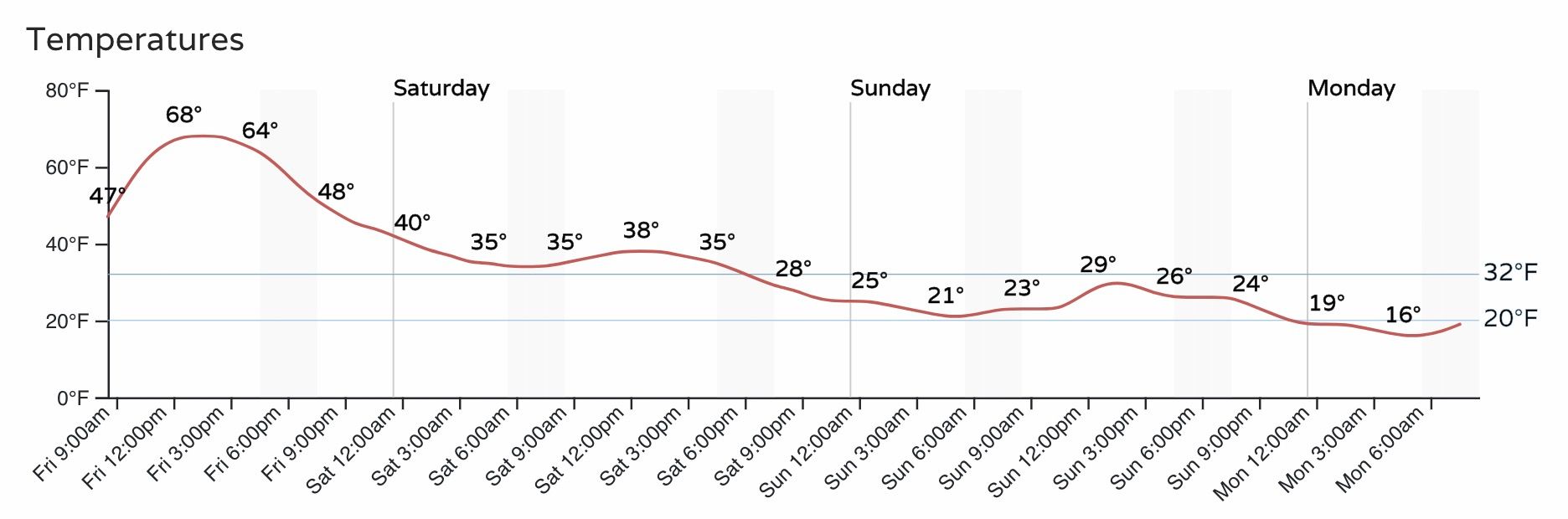
As discussed in prior updates, two waves will be responsible for bringing inclement weather to the state beginning this afternoon and continuing through Sunday night. The first will mean in increased chance for precipitation this afternoon and evening extending overnight into Saturday morning, with a bit of a break Saturday afternoon, before chances increase again Saturday night and Sunday.
Friday and Saturday
The first system is the trickier one to pin down, as temperatures and convective nature of the event means high boom and high bust potential.
Models show a push of moisture moving in from the southwest overnight tonight, with snow at higher elevations but at least initially rain for the urban corridor.
The latest 3km NAM model shows rain and snow pushing off the foothills around midnight tonight (though timing differs quite a bit between models), with a period of good rain and likely mixed precipitation for the urban corridor before things push north and east Saturday morning. The bulk of the precipitation tonight (both rain and snow) is expected to extend from Denver north.
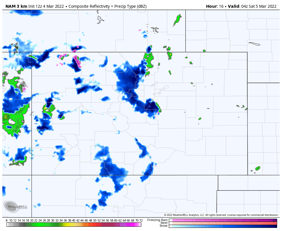
This particular model, as with most of the data, shows little to no accumulation tonight and Saturday morning for the greater Denver area, but several inches possible under the heavier convective snow up north (think Fort Collins, Greeley, Akron).
This seems like the best idea given the setup, but models also quite frequently will under do cooling, and it could be we see rain change to snow quicker at lower elevations leading to a few more areas seeing some quick-accumulating snow late tonight and Saturday morning.
Should this area of heavier snow materialize, look for totals from 2 - 4" to be possible by late morning Saturday under these heavier showers, again favoring those northern communities vs the Denver metro area.
From late morning Saturday through the afternoon we will be between systems. A secondary cold front will push through late in the day dropping us below freezing from Saturday evening through the remainder of the weekend.
Saturday night through Sunday night
While system #1 will have the convective wildcard and perhaps better moisture availability, system #2 will have more cold air in place, a better storm track, and perhaps more upside potential for more widespread snow accumulation.
So, as system #1 ejects to our northeast Saturday morning, you can see the stronger system waiting in the wings across the Southwest:
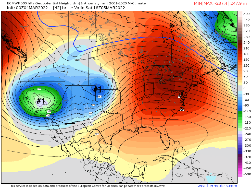
As this system moves through we will see an increase in mountain snow again Saturday and Saturday night, with snow redeveloping (or developing for the first time) across Eastern Colorado as well by Saturday night and through the day Sunday.
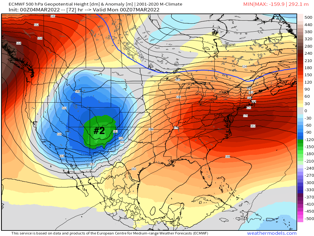
For those that don't end up under a freak snow band tonight/early Saturday, this will be your best chance of seeing accumulating snow this weekend.
Totals from 2 - 5" look most likely for the urban corridor and Northeast Plains. Light snow will increase in coverage Saturday night and continue off and on through Sunday night, with flurries possibly extending into Monday morning as we remain under the influence of the trough.
Temperatures Sunday will be cold enough for all snow, but sun angle does become more and more of a factor this time of year, and could help with roadways at least during daylight hours Sunday, though anything Saturday night or lingering snow Sunday night could cause travel issues.
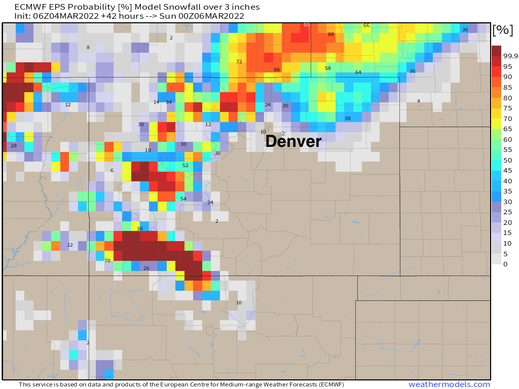
Snowfall totals
Looking at snowfall probabilities we see for tonight through Saturday afternoon the greatest snow chances will be across the mountains and Northeast Plains. This highlights well who's most likely to see a burst of heavy snow in round one, and that's communities north of Denver and up into Wyoming and Nebraska. Here's a look at probabilities for 3" of snow or more through 5pm Saturday:
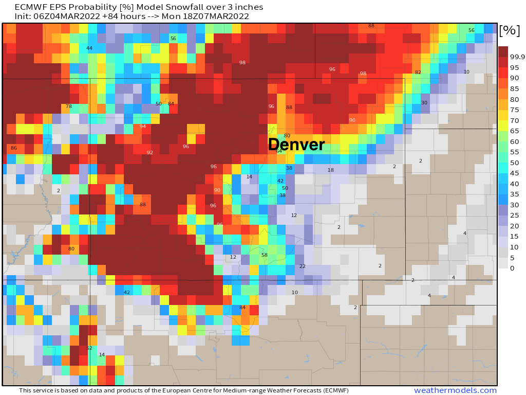
If we extend that through Monday morning we see much of the Front Range ending up in the >50% odds range for 3" of snow or more, with much lower probabilities south of the Palmer Divide:
SREF Plumes show the following breakdowns. Bottom line, most model guidance has low-end potential for snow in round one, with best chance for accumulating snow coming in round two. However, and we'll stress this, they may be failing to capture a band or two of heavy snow that could set up, with again the greatest probability being up across the Northeast Plains, but some potential that could end up south.
Friday/Saturday:
- Fort Collins: 0 - 1"
- Greeley: 0 - 1"
- Boulder: 0 - 1"
- DIA: 0 - 1"
- Highlands Ranch: 0 - 1"
- Elizabeth: 0 - 1"
- Colorado Springs: 0 - 0.5"
Saturday night/Monday:
- Fort Collins: 3 - 5"
- Greeley: 2 - 3"
- Boulder: 4 - 5"
- DIA: 2 - 3"
- Highlands Ranch: 3 - 4"
- Elizabeth: 2.5 - 3.5"
- Colorado Springs: 2 - 3"
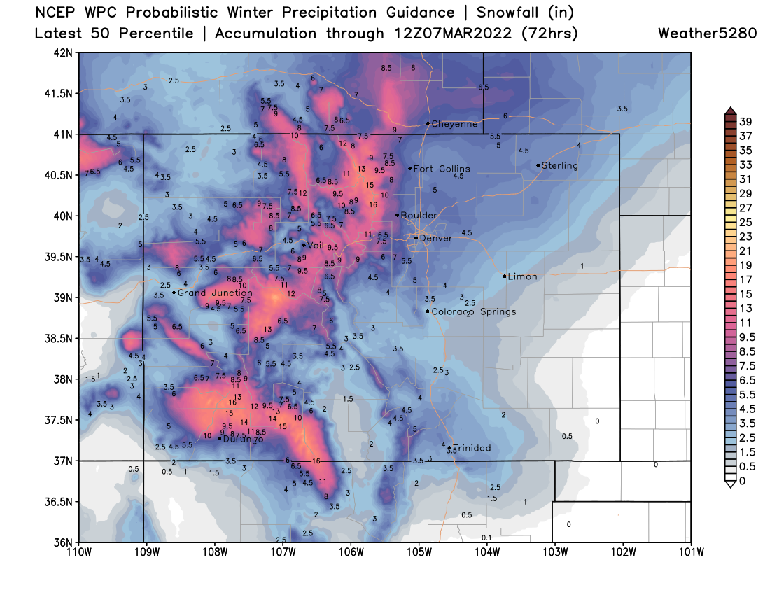
Our snowfall forecast includes both systems extending from 5 pm today through Monday morning:
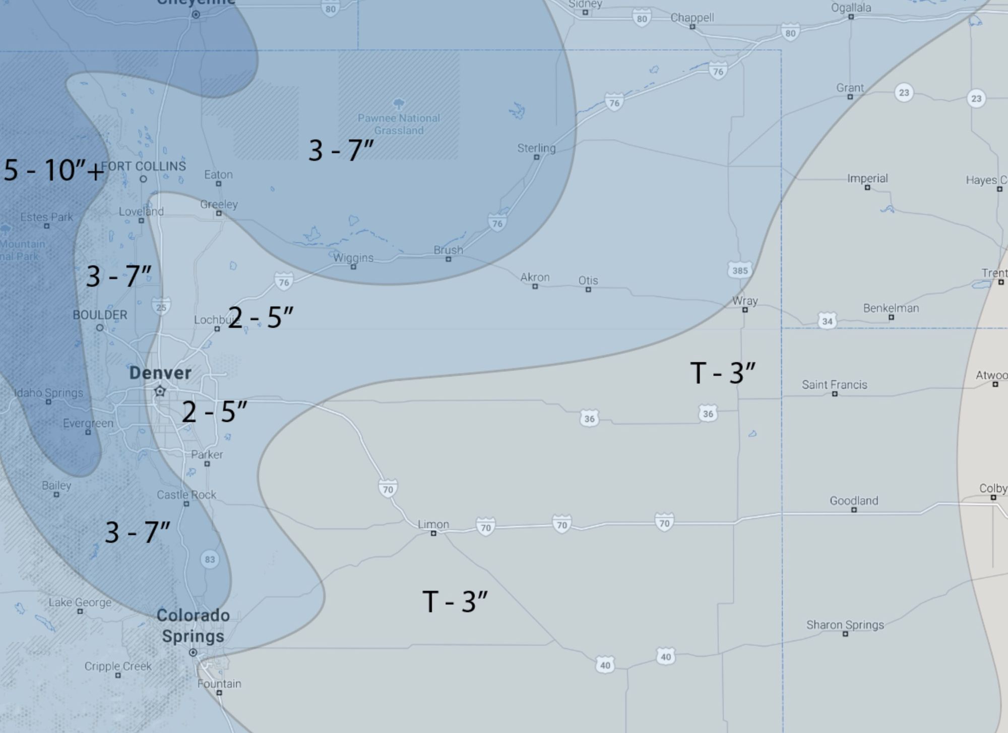
And finally, looking at the statewide picture, a great weekend for snowfall in the high country we are happy to say, with widespread totals of 12 - 24" looking likely for the higher peaks!
