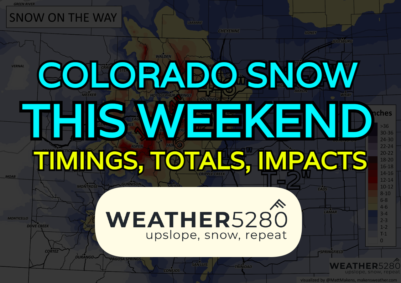
Winter Storm Watch posted for Denver, urban corridor; Snowfall forecast update for Colorado

Cold front #1 has left its mark in Colorado! High temps have crashed 20-40 degrees from our mild air earlier in the week. Our next front moves in throughout the day Saturday, bringing snow from north to south as well.
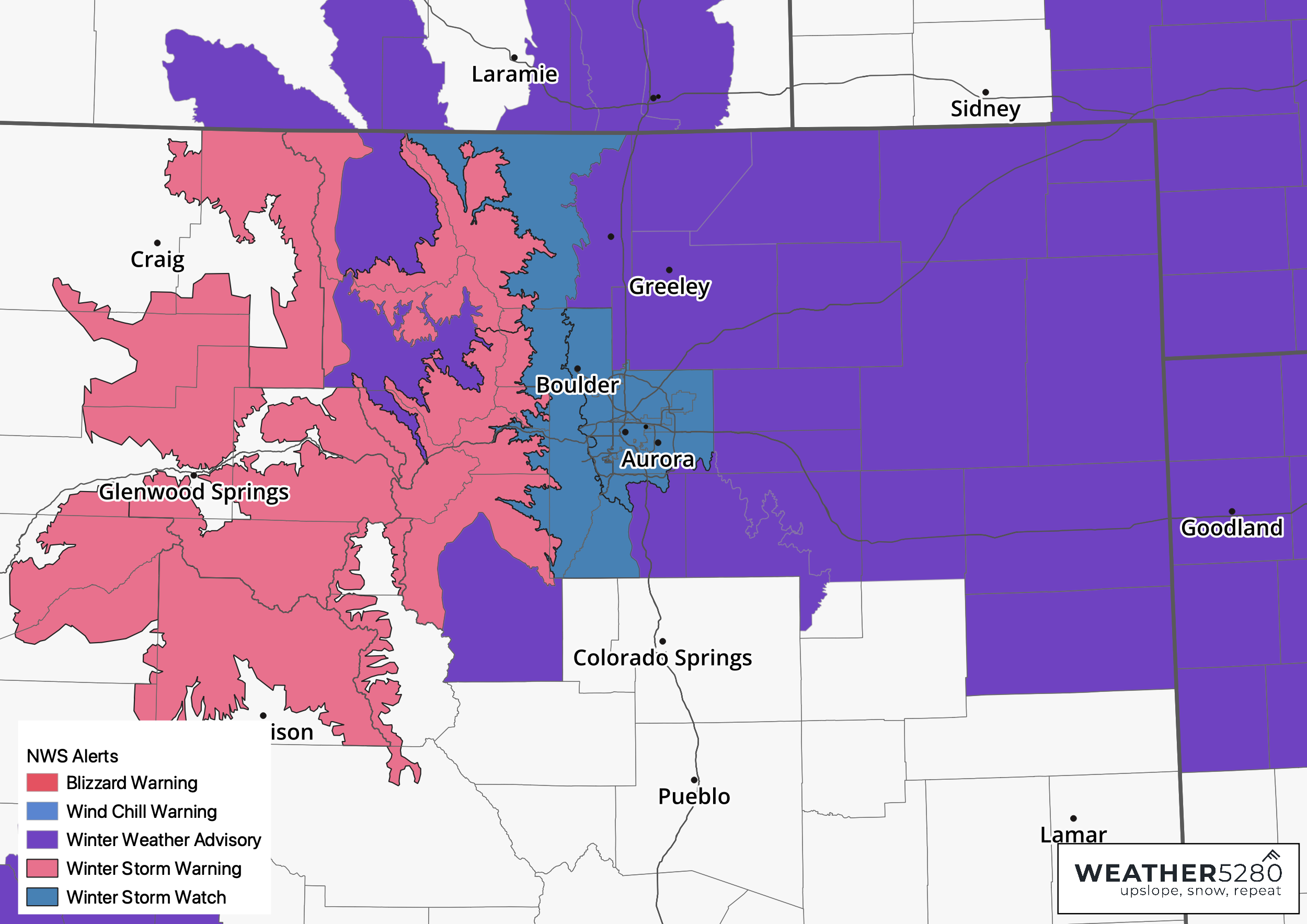
Not a lot has changed from our previous update yesterday. Below is the latest advisory map from the National Weather Service as of 2:30pm Friday afternoon. A Winter Storm Watch has been issued for the urban corridor in effect from early Saturday morning through early Sunday morning.
Timing it out
Snow will start to fly in the mountains late Friday night into early Saturday. Snow will be heavy especially over the I-70 corridor mountains by sunrise Saturday.
Light snow showers begin to breakout along I-25 around 7-9am. We may end up seeing a brief lull in the snow showers around or just before lunch in Denver up thru Fort Collins, with another band moving out of the mountains around 1pm Saturday. This should last pretty steadily all the way through the evening and into sunrise Sunday. This is where the bulk of the accumulations will be possible for folks east of the hills. Snow tapers off in the late morning Sunday for Fort Collins to Boulder, by early afternoon for Denver and Castle Rock.
For Southern Colorado we'll see snow showers begin north on the Palmer Divide after sunset Saturday, slowly settling into Colorado Springs by sunrise Sunday and ending for folks along and south of HWY 24 dinnertime.
How much snow?
This is still going to be tough to get down exact totals. Depending on how much snow falls in the Urban Corridor before sunset will be the biggest factor for initial accumulations. Temps Saturday afternoon hovering around 32/33 isn't favorable for accumulations. Ground temperatures are still in the 40s at that time too.
With that in mind, if you get under a heavy burst of snow to refrigerate the ground, you may start to see it stick to the roads. Elevated surfaces should begin fairly quickly for most Saturday morning.
We also have to take into account the banded nature of this snowfall, making it tough to pin down booms and busts which only may be a few miles a part. That's to say, if one of these stronger bands sets up from Arvada to Lakewood, but you miss out on it in Highlands Ranch to Aurora, the snow totals you end up with at the end of this storm may be dramatically different between those two areas.
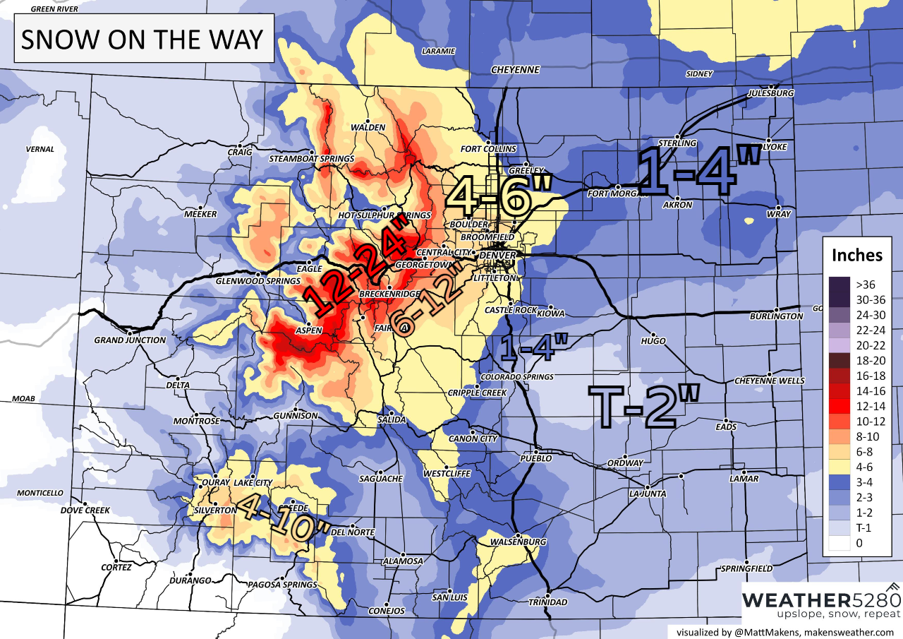
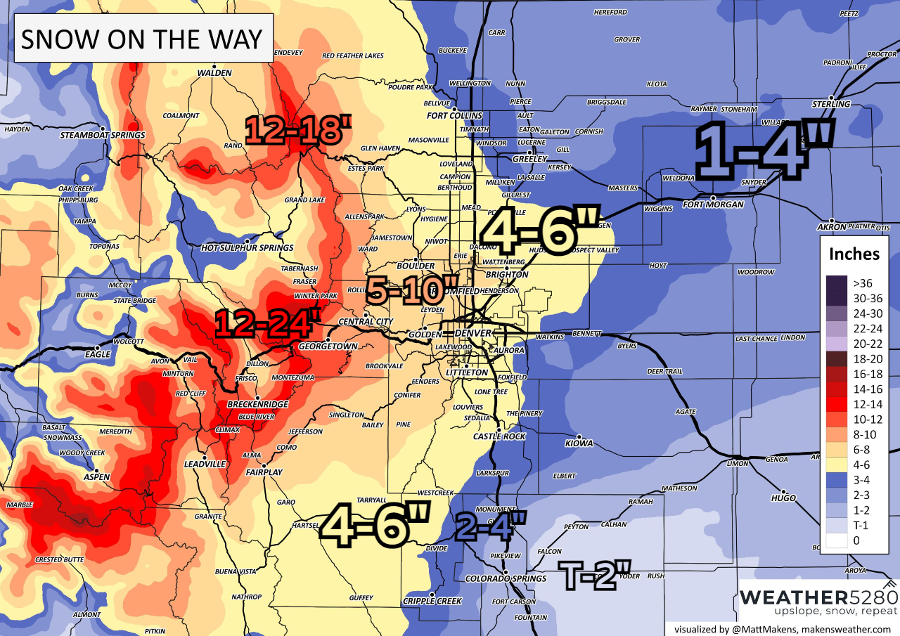
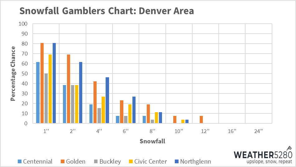
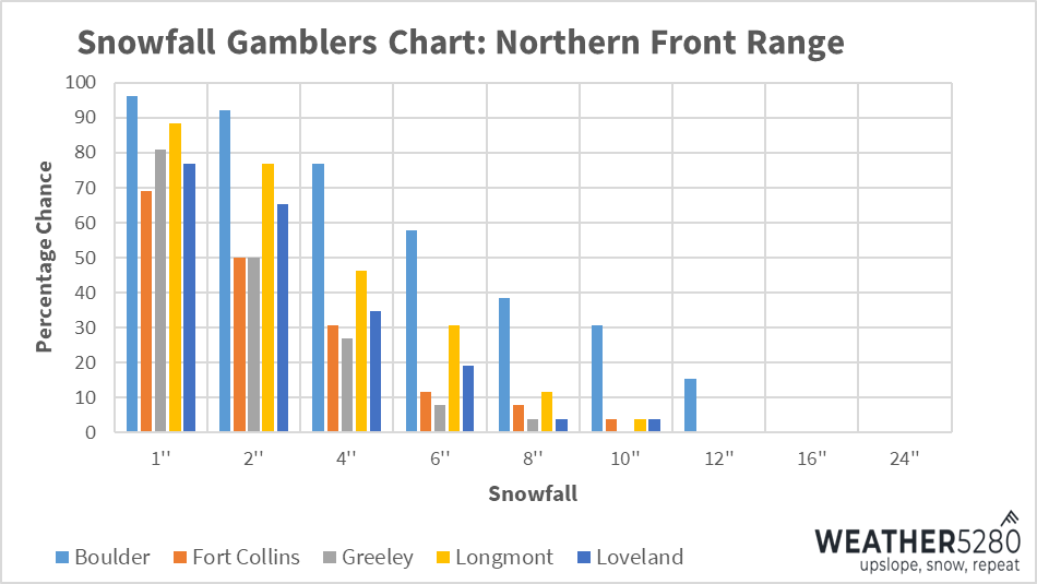
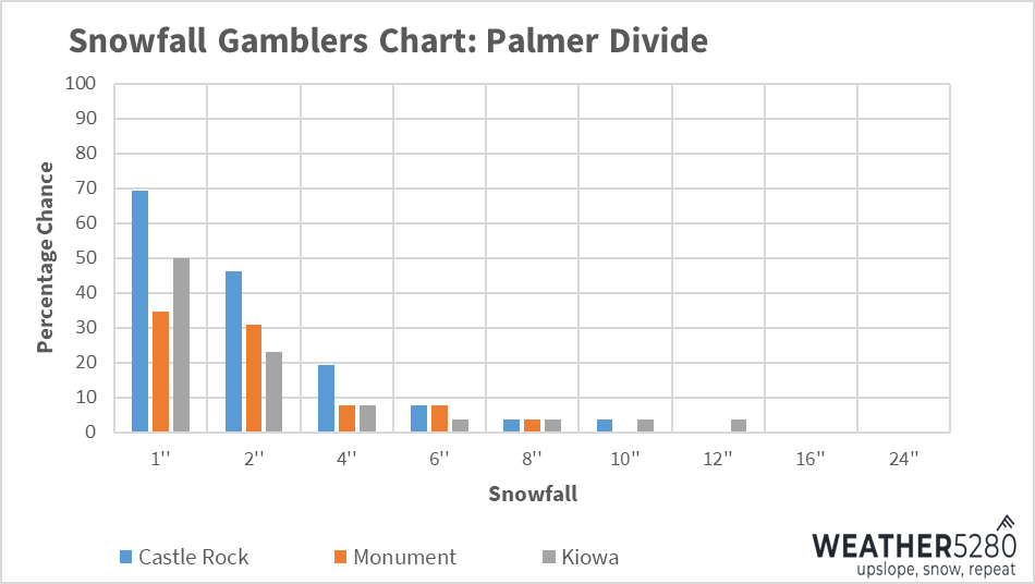
Another way we can break down the confidence of these numbers is using percentage graphs. Below, you can see that most areas around Denver have a pretty likely chance of something between 1-4", with some fairly decent chances of getting up to 6".
Notice further down the line, there's a very slight chance a few spots see "booms" up to 10" or more. While we're not expecting a widespread "boom" of numbers, a few key spots that setup under multiple bands from this storm could end up with hefty amounts.
What are the impacts?
Mountain travel will pretty quickly deteriorate late tonight and much of Saturday. Initially, snow shouldn't cause huge impacts at lower elevations with marginal temperatures. This should lead to mainly wet roadways Saturday afternoon.
However, as we set the sun Saturday evening and temperatures drop into the 20s, wet roadways have a good chance at becoming like hockey rinks, ESPECIALLY for areas under banding with heavy snowfall. I'm pretty concerned that travel will start to get bad for the foothills around 6-7pm, and quickly thereafter for the Denver Metro. Bridges and overpasses could become dangerous quickly.
A lot of folks will be out on a Saturday night, and could be even busier on a night before a Broncos game. If things "don't look to bad" in the afternoon, people may get the wrong idea about how quickly things turn into the evening hours. There's a lot of conjecture/guessing with all that, but we've seen that exact situation play out many times in the past.
If you can stay in Saturday evening, you're probably much better off doing so. It will also help road crews get things cleared up for Sunday morning.
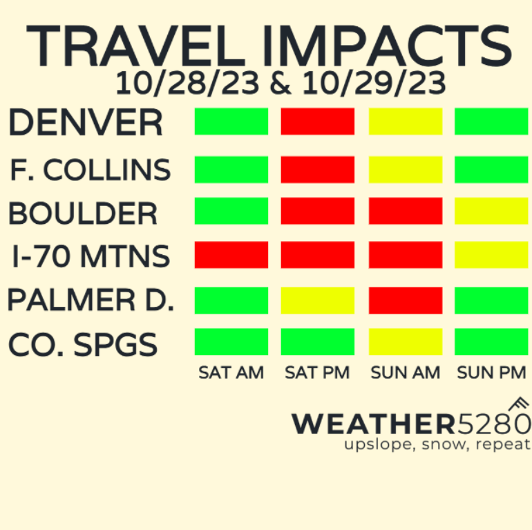
I think we'll start to see heavier snow bands tapering off Sunday morning, but getting around could still be a pretty big hassle, especially off of I-25. Side roads, and even some light-to-moderate thoroughfares will probably still have some snow on them, making navigating much of downtown Denver, especially ahead of the Broncos/Chiefs much slower than normal.
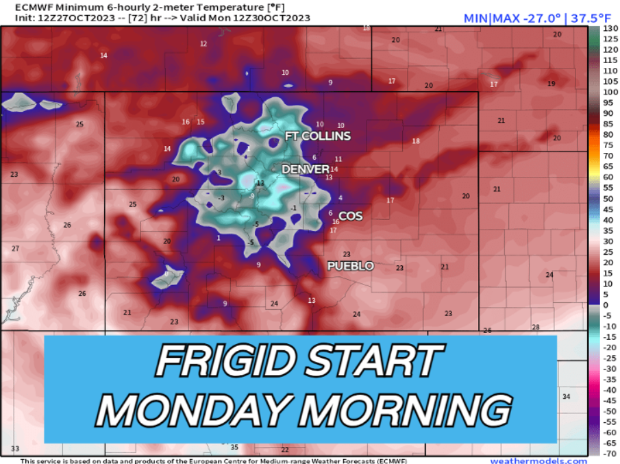
Road crews should have a pretty good handle on the major stuff by Sunday night – Monday morning's commute will probably be pretty good outside of a side road slick spot here and there. It will be bitterly cold for this time of year Sunday and into Monday morning. 20s for highs, with single digits and 10s for Monday morning! Bundle up!
More to come, and of course keep us posted in the comments below as the snow starts to fall on Saturday! We hope everyone is well prepped for the incoming storm, and as always, stay one step ahead of the changing weather by subscribing to our email list today!