Colorado weather: A colder and snowier weather pattern possible by Thursday across the region
First, a very Happy New Year to you all!
It hasn't been the worst start to the winter along the front range, but we certainly haven't seen any storm define this winter thus far, and some locations have fallen well behind their seasonal norms for snowfall to date. That has a chance to change as several waves of low pressure look to speed across the region later this week and next weekend.
One of our biggest missing factors so far has been the lack of true cold air. Model data seems like it wants to push some of our coldest air of the season for this possible late-weekend/early next week event.
We'll also are tracking the potential of multiple snow chances too.
A look at the next 10 days of temps, a pretty clear downward trend looks like it's on the way. We'll kick off the new week/year with fairly mild stuff. Mid-to-upper 40s for most along I-25 and east, cooler temps in higher elevation spots.
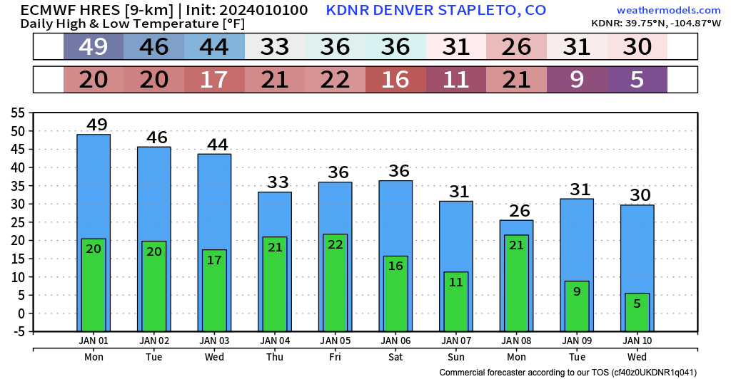
Notice the bump down on Thursday and Friday with that first storm system, then the potential for colder air early next week. Nothing's a home run even 24 hours out when forecast Colorado weather, but this certainly has the look of a chilly start to 2024 along the Front Range and across Colorado.
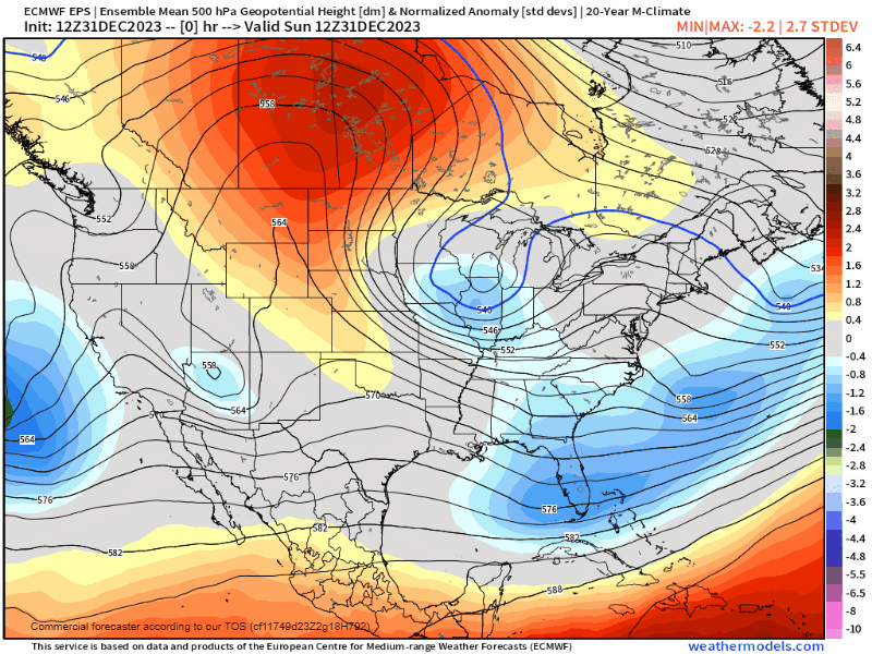
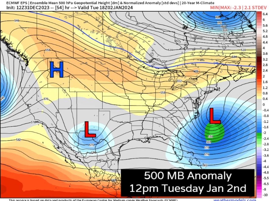
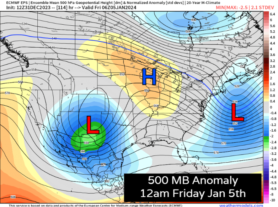
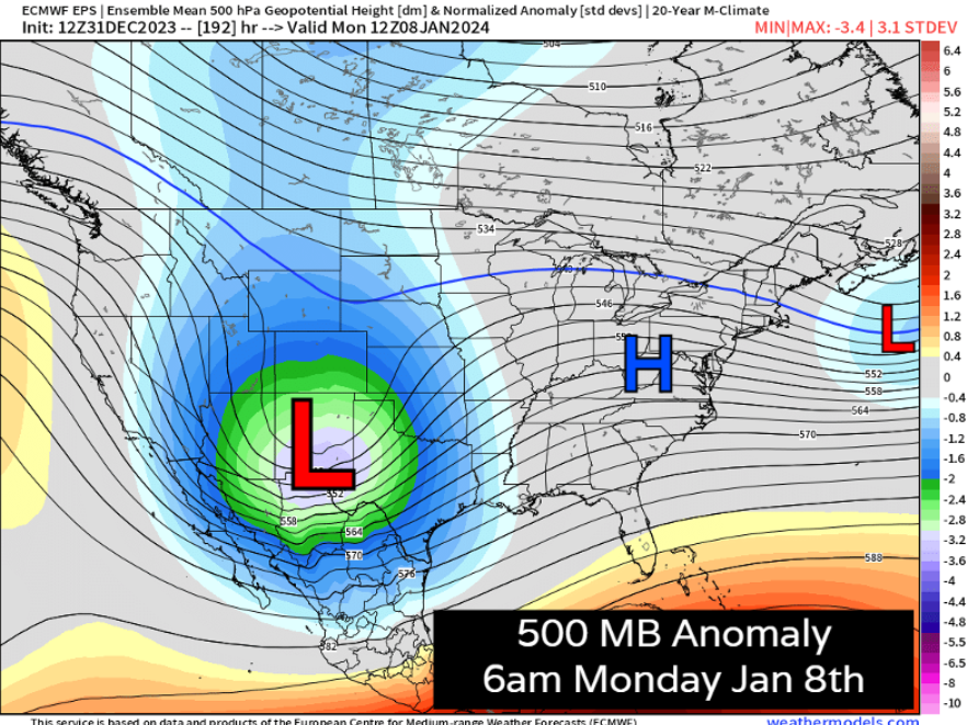
500 mb charts from the Euro ensemble show a parade of several storms between Wednesday (Jan 3) through Monday (Jan 8) and even in the wayyyy long term it looks like we'll keep an abundance of cold air close by, with any little ripples of energy having the potential to produce some additional storm chances.
We can break this pattern down into 3 separate times to watch for storm activity. System number one approaches as a weak wave, mainly dissipating over southern New Mexico and Texas on Tuesday. We're not expecting this system to bring much of an impact to Colorado.
Looks like we have a bit more hope with the storm system Thursday night into Friday morning. For the northern front range, we'd like to see signals for this thing to be a bit further north – but for Colorado Springs, Pueblo, and especially areas over the Raton Mesa and southwest mountains, this storm could bring some impacts. Overnight runs from some models brought this system a bit further north... so this we'll be watching closely today to see if that trend continues. Right now, areas north of about Denver are less-favored for snow Thursday, but that could change.
A shortwave passes through on Saturday and could bring additional snow to the high country, but minimal impacts to lower elevations.
By Sunday we will be tracking the next trough to dig into the Great Basin, with eventual impacts to Colorado. This looks like it will barrel up some cold Alaskan air which dumps south, while also phasing with a ripping subtropical jet that sets up this week. These kinds of set ups can produce memorable front range snowfall... BUT you definitely need the pieces to fall into place.
Right now, this feels like our most promising setup so far this winter. Can that change? Yup. We've had a couple storms look pretty good in the mid-to-long range this season that really haven't lived up to snuff. In fact, latest guidance is again threatening to pull this system too far south for the northern urban corridor much as we've seen several times this season.
Regardless, we've got the itch this week. We'll be on top of the changes to this forecast and make sure you're up to date. The first chance of snow looks to arrive Thursday to parts of Eastern Colorado, so you'll want to stay tuned as we kick off the new year!
Remember to subscribe to our email list if you haven't already. We'll be chompin' at the bit to give you those latest updates throughout the week!