Colorado Weather: Snow potential remains uncertain Wednesday night, Thursday

Big time thaw-out in action out there Monday and Tuesday! Temperatures Tuesday afternoon are in the mid-to-upper 40s for many throughout the Urban Corridor.
The next big question on our plate is what happens with this thing:
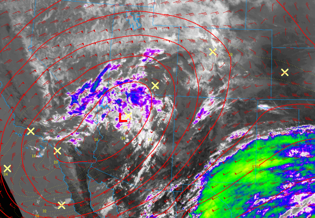
That's satellite imagery of the upper-level low pressure system expected to move through Colorado Wednesday into Thursday. A lot of question marks have been hanging on this thing as model data has had a tough time trying to figure out exactly what this wants to do.
Here is the latest evolution of the low from this morning's European model run:
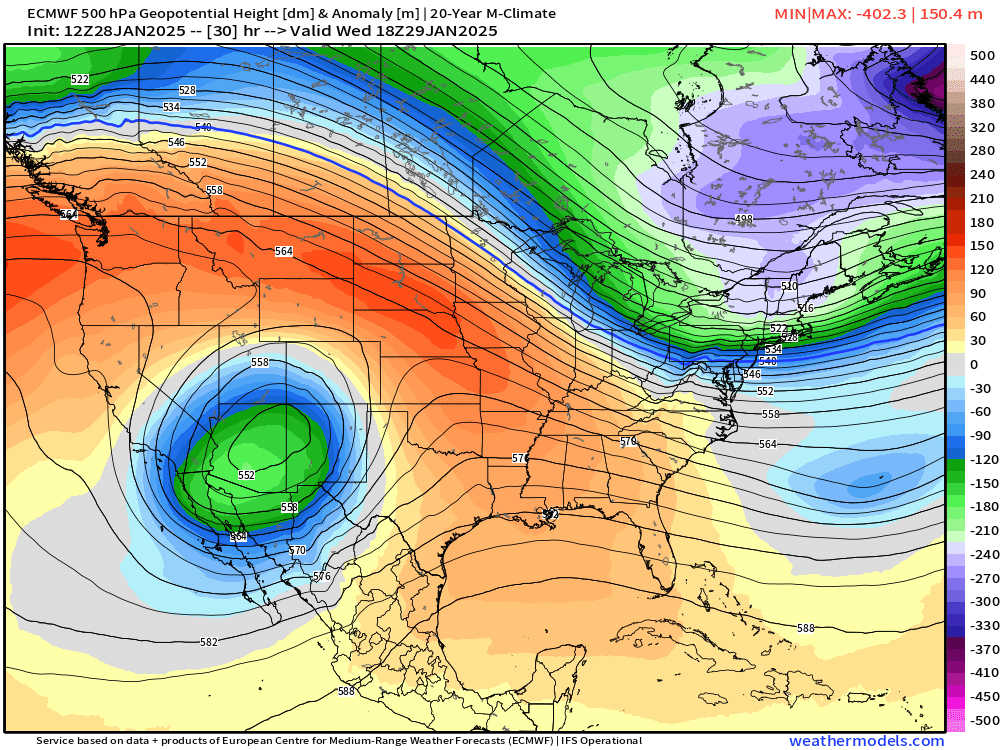
This first image gets us through the next 24 hours... A pretty decent looking storm as it move into the 4 corners. Quickly thereafter, we see what could happen in the image below:
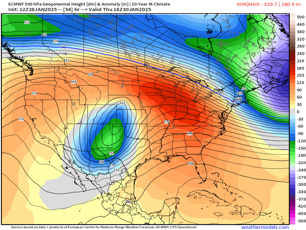
The storm quickly begins to stretch and shear out (notice it's far less symmetric, more elongated) as it moves onto the east side of the Rockies Thursday afternoon. This type of stretching and shearing tends to yield less impactful storm systems.
I've been pretty concerned about this for most of the week... while the track is just about as good as you can get, the lack of organization of this system will likely be its biggest downfall. To boot, this storm is also lacking cold air! So if you DO get snowfall, expect it to be wet and heavy, not dry and powdery like the last few systems.
All that being said, we do plan on having snow in our forecast... and we do have some totals, but the ranges are a bit wide, so bear with us. In a forecast like this, you can usually lean on terrain-areas for the best snowfall chances.
A few spots like the Ramparts (between Jeffco and EPCo), parts of the Palmer Divide and the Sangre De Cristos southwest of Pueblo likely end up with the most snow.
Snowfall timing
Snowfall looks to pick up after sunset Wednesday night and linger through the first half of Thursday. Snow will start a bit earlier for the San Juan mountains and southern Colorado mountains as early as afternoon Wednesday. Snowfall should end for most of the state by Thursday afternoon.
Snowfall amounts
Below is our charts for totals across the state. Generally something between a T-4" is expected for the cities along I-25 including Denver and Colorado Springs. Up north to Fort Collins, you'll probably steer clear of much snow on this thing.
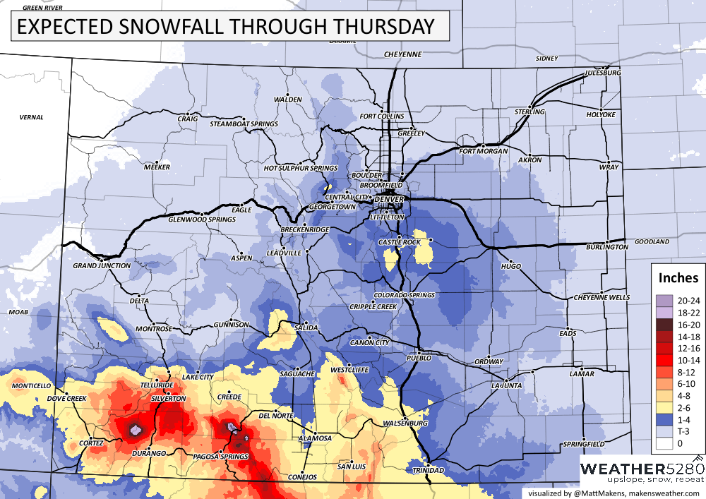
Up over the Palmer Divide we have our bit of a wild card... I'd say, depending on where some localized banding sets up, 1-6" of snow could be on the table... exactly where?... Uhh... Maybe somewhere? Again, this just illustrates the unreliable nature of this storm in particular. Throw in the marginal temps, the window for impacts is likely only a brief 1-2 hours during the Thursday morning commute.
Check out the southern and southwestern mountains though! Big snows are expected along HWY 160 through the San Luis Valley too. it looks like 8-16" is most likely over the San Juans... mountain travel in that area looks NASTY Wednesday afternoon through Thursday morning.
Overall, this doesn't look like it's going to be much more than a nuisance for most... but it feels like there could be wildcard at play here (yes we see the HRRR playing games today), and that there will definitely be a few trouble spots. If anything big changes, we'll give you a heads up!
Stay tuned!