Colorado weather: Heavy snow for the mountains, rain on the way for lower elevations

A significant area of low pressure is expected to move into the four corners starting Sunday night, bringing impacts to Colorado potentially through Wednesday morning.
While this spring was fairly tame with respect to these types of systems, turning the page into May looks to be pulling no punches!
Let's time out these storm system, as it looks to come through in two main waves.
WAVE #1 – Late Sunday night through Monday evening
For now, Sunday morning is looking dry for most of the state. By Sunday afternoon and evening, mountain rain and snow showers will start to fire with the heating of the day. Don't expect a whole lot initially... most of it will be isolated.
As we progress into Sunday night, showers will become more numerous, and eventually more focused across eastern Colorado. Moisture looks especially promising for southeast Colorado during wave one.
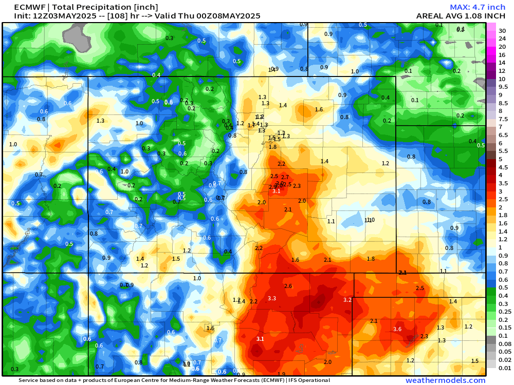
In terms of moisture amounts, Wave #1 could be significant for some along the I-25 corridor. Here is the 24 hours precipitation forecast from the Euro ending early Tuesday morning, with 0.5" to over 1" of QPF forecast by this model from Fort Collins south through Colorado Springs:
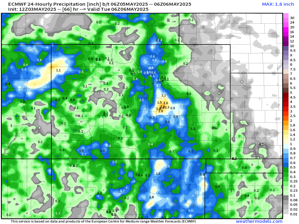
With low level winds focused out of the southeast most of Monday, that puts the Pikes Peak Region under the most significant upslope potential. As seen in the map above, El Paso County could be our big winner initially.
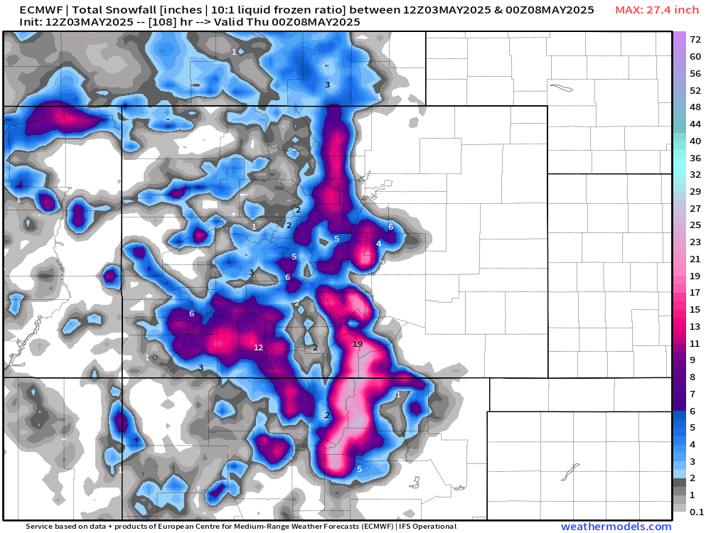
Higher elevation locations have the chance to see some moderate snow, especially in the foothills and the southern mountains, but even a bit of snow or mixed precipitation across the Palmer Divide is possible:
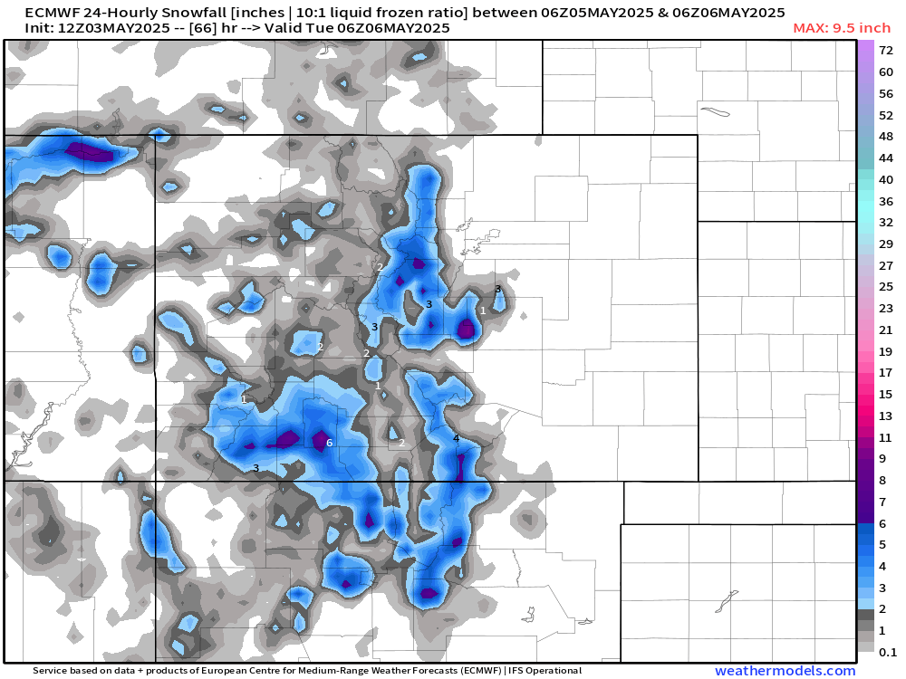
Looking at the bigger picture – Wave 1 is likely the weaker of the two. But for cities like Colorado Springs, it may end up being the more significant part of this event.
We should see a pretty substantial break after midnight Monday into Tuesday morning.
WAVE #2 – Late morning Tuesday through Wednesday morning
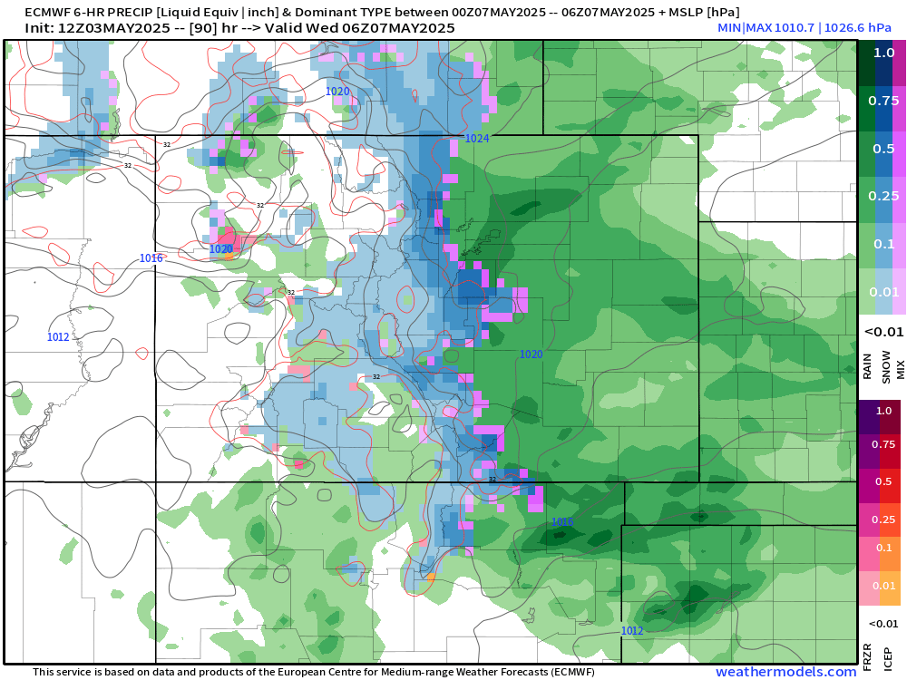
Wave 2 will come as the main area of low pressure begins to pivot across the south side of the state. This should bring us a better setup for a wider swath of Colorado to see higher impact weather. This will also feature colder area, so heavy snow as low as 7,000ft could be possible. This includes Monument Hill and Teller County, as well as the potential for heavy snow in the foothills west of Denver.
For all other locations, RAIN is likely during this time.
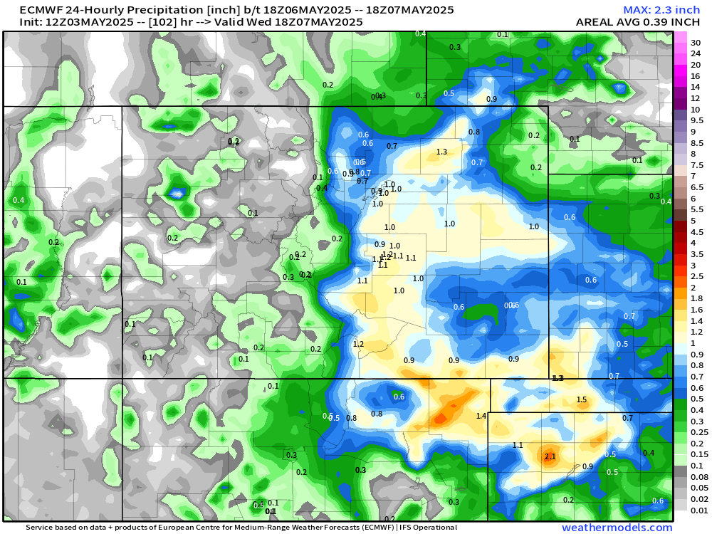
As seen on the precip charts, theres the potential for up to an INCH of liquid across a large chunk of eastern Colorado. This would be VERY welcome moisture as much of the spring so far has been much warmer and drier than normal.
Below is the snow chart for Wave 2. Foothills could see an additional 3-6", the Sangre de Cristos could see some significant snow, up to and over a foot.
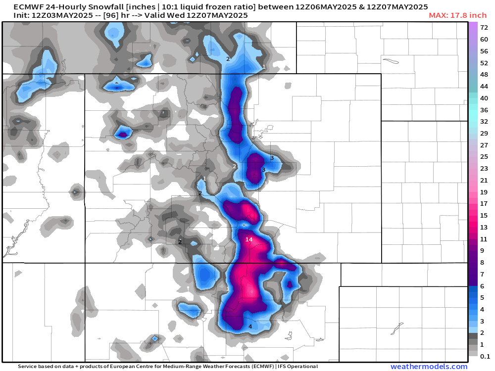
Overall, the I-25 corridor should only see rain impacts, but anything above about 7,000 ft could be pretty slick. Keep that in mind for Tuesday evening and Wednesday morning.
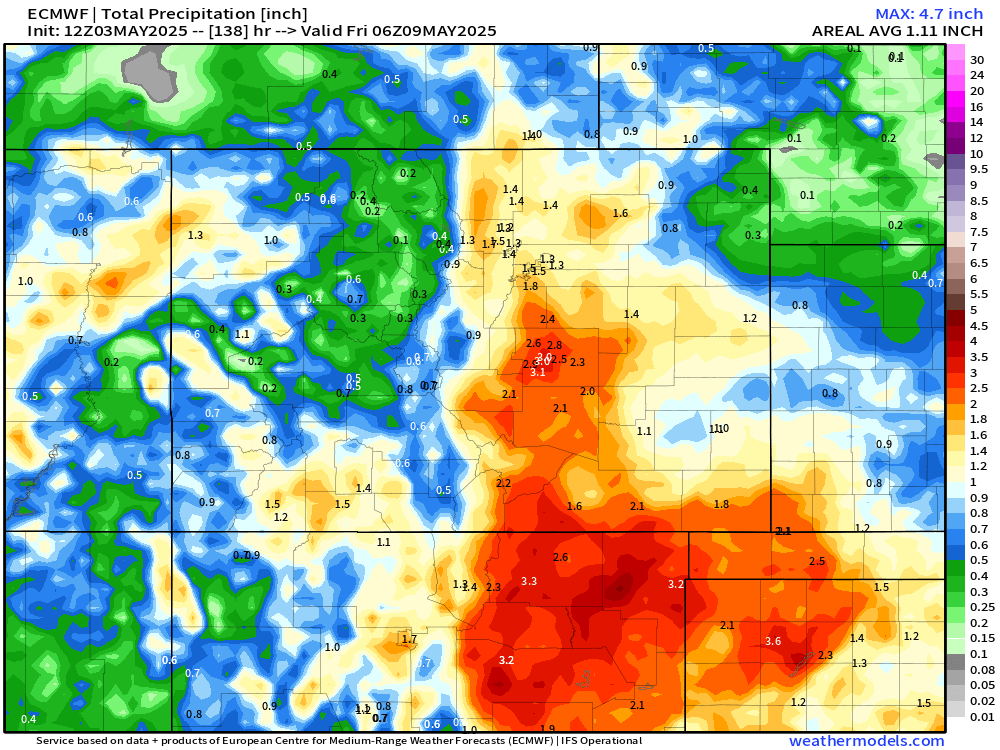
All things being said: this storm system is likely high impacts in terms of length of time and amounts of rain and snow.
Below are the storm total precip and snowfall amounts from tonight through Wednesday evening:
Gotta love to see a storm like this in early May, hopefully we can keep the train rolling throughout the month!
We'll let you know if there's any other important info on this storm over the next few days.
Otherwise... enjoy the moisture!
Luke