The State of the Atmosphere for Sunday, October 13, 2013

Despite a cool breeze, temperatures today warmed into the mid to upper 60s across the metro area to close out the weekend. No day over the next week is likely to be as warm as today's weather.
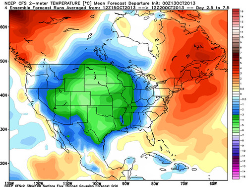
The coming week is shaping up to be much cooler than last, with highs mostly in the 40s and 50s for the metro area. The NCEP CFS surface temperature departure for the next seven days (right), shows a broad swath of the middle of the country of well below normal temperatures.
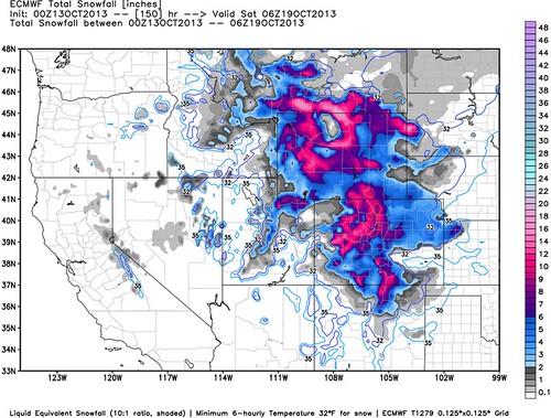
There is a rather potent disturbance that will bring rain and snow to the state Monday and Tuesday. For the north-central mountains, winter storm warnings and advisories are already in effect as another round of heavy snow could bring upwards of 10" of snow for some locations by Tuesday morning.
In Denver, we may see some shower activity Monday into Tuesday, and at times this may mix with wet snow. Not a whole lot of precipitation is expected with this disturbance for Denver, so only keeping a slight chance for rain and snow in the forecast through Tuesday evening. No accumulation of any type is expected at this point.
Where the forecast starts to get complicated is Thursday into Friday. The Euro and GFS models have been remarkably consistent, but each with a different solution. The Euro digs another strong trough across the region and with it our coldest temperatures of the season and first widespread accumulating snow. The GFS on the other hand, has the trough well east of Colorado, with a big goose egg for any precipitation across the Front Range, and moderating temperatures. Case in point: the 0z runs last night featured a nearly 25 degree; temperature difference between the Euro and GFS for next Saturday morning.
To complicate the matter, there is no real agreement one way or the other from the Canadian GEM and or Japanese JMA models either. The GEM which was closer to the Euro model yesterday has wobbled a bit more in the direction of the GFS solution, while the JMA produces a pretty good trough, but is slower than the Euro.
With little confidence in either solution, will stick to a middle of the road forecast for now. I have knocked temperatures back a bit for Friday, and introduced a slight chance for precip (rain or snow), and will wait for the models to begin to come to an agreement before making additional changes one way or the other.
Next Saturday marks date of the average first snowfall in Denver. As we are still awaiting our first measurable snow here in the metro area, and with the opening of Arapahoe Basin this morning, here is a list of the first measurable snow over the last ten years to get you in a snowy mood:
- October 5, 2012
- October 25, 2011
- November 15, 2010
- October 21, 2009
- November 14, 2008
- October 22, 2007
- October 18, 2006
- October 10, 2005
- November 1, 2004
- November 5, 2003
We will track all the latest developments (or lack there of) as the week progresses, stay tuned!