Steamboat Weather Summit 2014 Part III

Greg Carbin: Warning Coordination Meteorologist, Storm Prediction Center; Review of 2013 Severe Weather and Forecast Product Enhancements for 2014
Greg Carbin, meteorologist with the Storm Prediction Center (SPC), is a master presenter, not because he's flashy and full of fan-fare, but because you can't help absorbing his passion for data and wanting to feel just as motivated. During Greg's presentation at the 2014 Steamboat Weather Summit, I couldn't help but to notice how engaging and intelligent his approach to meteorology is. Greg offered a unique perspective on the SPC, it's mission to enhance the efficiency of severe weather warnings, and improvements on the way for the 2014 severe weather season.
2013 ended at a historic low tornado count for the second year in a row. The SPC has confirmed 891 tornadoes in 2013, far below the average of over 1,000. Hard to believe considering the devastation in central Oklahoma and associated deaths from the tornado outbreaks there and elsewhere. For Moore and El Reno, Oklahoma, it wasn't a quiet tornado year.
The number of strong and violent tornadoes has not changed in decades, but the ability to detect and warn has changed. Remarkable improvements to radar, satellite, and modeling technologies are aiding the SPC and local weather service offices in earlier and more targeted tornado warnings (not to mention the importance of hail, wind, and fire threats too).
The mission of the SPC is to provide severe weather guidance up to a week in advance. The longer term guidance is aided by ensemble forecast modeling, which you can view on the SPC website, while the shorter term guidance is aided by higher resolution modeling, also available through government and educational websites.
As part of its mission, the SPC outlines threat areas as severe weather is predicted via modeling. But despite the SPC's short and long-term guidance, it's up to the local National Weather Service (NWS) office, a separate entity to the SPC, to monitor radar and issue timely warnings to the public. The division between the two organizations is clear -- the SPC and NWS serve different yet related functions, often resulting in a communication gap.
The NOAA Hazardous Weather Testbed has been created to bridge that gap. By tying radar and high resolution model data together, the Hazardous Weather testbed hopes it will improve warning lead times to the public. Currently, a tornado warning is only issued for a storm producing a tornado or clearly trending to the development of a tornado based on radar data. Consider the case of the Moore tornado, in which the warning time was a bit more than 10 minutes. By using today's state of the art modeling, authorities can improve that warning time to 20 or 30 minutes by not only relying upon radar verification, which exactly what the Testbed is hoping to accomplish. Let's hope they move out of experimenting into full operation soon.
Related: Preliminary Findings and Results from the 2013 Spring Forecasting Experiment
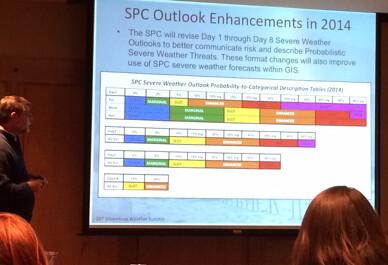
You will see some changes coming in 2014. Experimentally, a new SPC Outlook is coming down the road. After a bit of experimentation and feedback, the new enhancements will become operational.
Tomorrow we'll wrap up this series on the Steamboat Weather Summit with a trek to the Storm Peak Laboratory, and some notes from Don Day, the mission meteorologist for the Red Bull Stratos Space Jump.