Thursday Evening Update: Prepare for a Cold and Wet Friday

If you saw the thick clouds over the Front Range today, then you've already noticed the first few signs that the weather is changing. Despite the warm temperatures, the clouds marked a change on the way.
These clouds are the leading line of the next winter storm. Right now over Utah and Idaho, the system has a good amount of Pacific moisture to push over Colorado to end the week.
Friday morning drive to be easier easier than the afternoon
The storm will push over the greater metro area early Friday, lasting through the evening. There will be some minor impact to the morning commute, but a bigger impact to afternoon and evening drivers. The chance of rain and snow will increase by midday, remaining through the evening, and tapering off into Saturday morning.
Like the past couple of systems to visit the Front Range, you can expect a temperature drop with rain and snow -- and highs will be in the upper 30s and lower 40s.
Any snowfall accumulation is subject to rapid melting. Grassy areas in some locations will have a few inches by evening, and there will be some roads that have a slushy mess by the evening commute.
We expect the snow to continue into the early morning hours of Saturday. It's the snow during the overnight hours Friday that will have the best chance to accumulate. With slowly dropping temperatures, the change from rain and snow to all snow will likely happen in the afternoon, and the system will turn to all snow overnight Friday into Saturday morning.
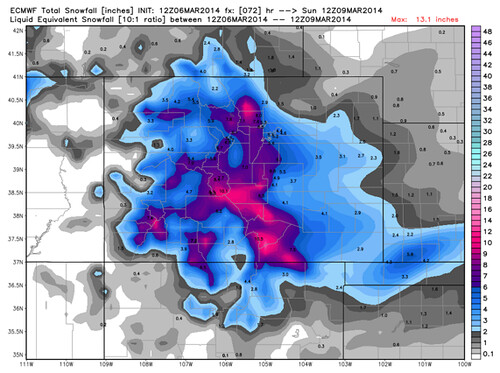
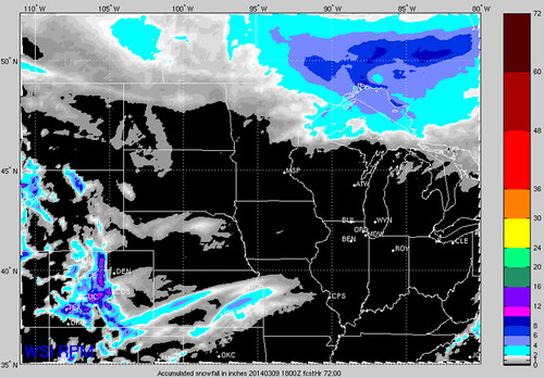
The amount of snow we receive will depend on the time of day that the rain and snow changes over to only snow. This event is very determined by elevation. Assume a slightly earlier changeover and the ECM (first image) will likely pan out with some good totals for the western and southern Denver metro area in elevations above 5,500 ft. If the changeover occurs later, as in the RPM (second image), the accumulation will be less in Denver and higher for elevations above 8,000 ft.
Skiers and riders will have new snow this weekend
The mountains will begin to see snowfall from the late this evening through the day Friday. Winter weather advisories in the central and western mountains call for 6 to 12 inches of snow by early Saturday morning. Travel will become more hazardous Friday through early Saturday.
Another impact will be the wind, especially in the high country, with gusts of 35 mph and higher. The wind may also increase for the foothills near the Front Range overnight as the system draws closer. This will create areas of blowing snow and reduced visibility.
We'll be tracking that changeover for you throughout the day Friday, and keep you up to date with any further developments as this storm gets underway.
Sunshine returns quickly Saturday to melt off any snow that does stick!