Update on Late Season Winter Storm Headed for Colorado
We believe that our overall forecast still on track: a major late winter storm is set to impact much of Colorado starting Saturday night and continuing into Monday. Highest impacts from this event are expected to come in the form of downed trees and power lines where heavy snow does accumulate. Travel will be difficult at times Sunday and Sunday night, especially heading west where snowfall totals in excess of 10 inches will be likely.
For Denver, the snowfall forecast remains uncertain. We are calling for 4 to 10 inches of snow through Monday, with highest totals expected to be west of I-25, and across higher elevations south of Denver. With so many variables in play, here are a few things to keep in mind:
- Not everyone will see impressive accumulation with this system given the nature of the storm and time of year. Keep in mind that even if you're seeing more rain than snow, or more melting than sticking, a few miles up the road it could likely be a completely different story. Also, given how leafed the trees are already, it won't necessarily take huge snowfall totals to do real damage.
- Warm surface temperatures will likely hinder snowfall accumulation on paved surfaces through the day Sunday, but that could start to change overnight Sunday into Monday. Even with lots of surface melting, leafed trees will be extremely susceptible to accumulation of this heavy wet snow.
- Given the time of year this is occurring, models will no doubt have a difficult time pinning down rain vs snow at particular elevations, so we will continue to see how things setup today, and adjust the above map as necessary as we head into Saturday night.
Understanding the Bust Index
The National Weather Service has now issued a Winter Storm Warning for much of the immediate Denver metro area, along with the foothills and mountains west of Denver. For the higher terrain this is looking like a sure-bet high impact event, with 8 to 16 inches plus possible for the Front Range foothills, and up to two feet expected for the north central mountains.
The Bust Index (BI) is our way of communicating this uncertainty. This storm has a high "bust potential" for lower elevations, as there are a host of things working against snowfall accumulation in Denver. A higher BI means a greater potential for snowfall totals to be lower than forecast.
We will keep the BI high for Denver for the time being, and adjust as necessary. Notice the BI is lower further east, but so too are the projected snowfall amounts. To the west, we have a lower BI as well, given more confidence at higher elevations.
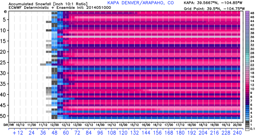
While some models continue to show very little snow for Denver, others (even some very reliable ones) continue to bring very heavy snow. Take a look at the ECMWF ensemble forecast from last night. Notice how many members have very high snowfall totals for Denver. This makes for pretty good confidence that we'll at least see some snow in the city.
A very wet system
As we've been saying all week, this will be a very wet system. Regardless of how much snow you see, expect a pretty soupy 48 hours. Even as some of the more bullish models have trended drier over the last 24 hours, other very good models have stuck-to-their-guns.
Here's a look at the 12z GFS for total precipitation through Monday.
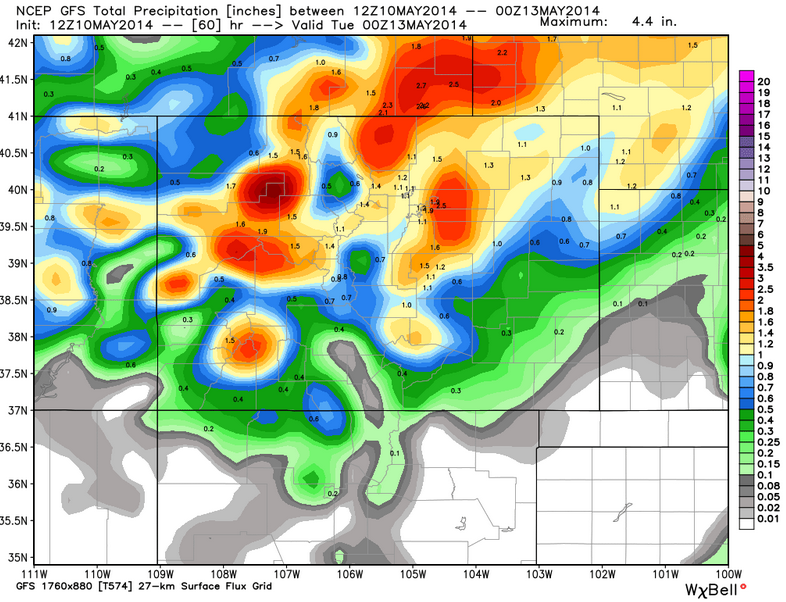
Other models show a very similar solution, with widespread precipitation totals for northern Colorado still in the 1 to 2 inch range.
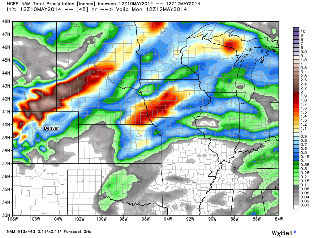
The NAM on the other hand, which at one point was the outlier for the heaviest snow in Denver has shunted the core of heaviest precipitation well north of Denver in recent runs. We generally weight this model lower than both the GFS and the EURO, but something to keep in mind as well...
Cold system for May
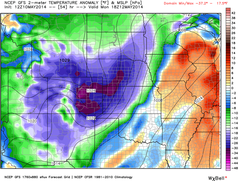
The other part of the story will be the COLD temperatures for May. Again, if you have already planted flowers for the season, heads up. Temperatures early Monday could challenge the all-time record low for the date -- with some of the models bringing in teens for lows. We will keep lows a bit warmer than that for now… but pretty much no matter what way you look at it, it will be very cold.
Here's a look at temperature anomalies for Monday according to the GFS. Wow!
Impact on Coloradans
While we've been talking about this storm since early in the week, the sentiment of most people seems to be that this storm isn't going to materialize because of the time of year. To think that would be a mistake; this storm is unusually cold for this time of year, and has a lot of moisture to utilize. Those two factors alone should make one take notice. While the uncertainty of the actual snow totals is apparent, the fact that it is going to snow and it is going to be very cold for May is a certainty. If you have travel planned in the mountains, you need to be prepared for some serious wintertime travel. At lower elevations, these same conditions may exist too...especially Sunday night and early Monday. PLEASE...be prepared.
Setting up to be a very busy couple of days here at Weather5280, so stick with us through the duration for all the latest! We'll see what today's EURO does and likely post another update later this afternoon or evening. If you haven't already, please subscribe to receive updates when we post, and follow us on Twitter for continuous updates.