Colorado Snowfall Totals February 20 - 22

The heaviest snowfall from this weekend's storm is done for the greater Denver metro area and northeast Colorado. Snow showers will continue off and on through the afternoon and into Monday night, with light additional accumulation expected. Denver may see another 0.5 - 3" by Monday morning, with a fluffy 1 - 4" possible for the higher terrain west and southwest of town.
Storm recap
Overall we feel good about the snowfall forecast we put out for this storm. A few locations did come in a bit low, but most of the metro area saw totals as forecast. Our forecast for Denver was 6 - 12", most locations landed well within this range, including 9.1" (storm total, 6.9" Sat-Sun) at our station in central Denver. Higher totals were observed south and west of the city, as expected.
A few places we were too high were for were parts of Colorado Springs, and a spotty locations across northern northern Colorado. Front Range mountain locations saw highly variable snowfall from this system, with more possible into Monday.
In the case of Colorado Springs, we mentioned in yesterday's post that this was where the "greatest uncertainty" remained, and the potential snow-hole that may occur if downsloping winds kicked in too quick. Sure enough this happened for some, leaving parts of southern COS with <6" of snow. Snowfall today and tonight might end up getting most of the Springs to the >6" territory in the end, with hi-res models suggesting another 1 - 4" is doable over the next 15 hours. The upper end totals here will favor areas closest to the mountains, with less snowfall expected the further east you go.
For the northern Front Range communities that saw less snow it was a similar situation, downsloping winds of the Cheyenne Ridge ushering in drier air which killed the snow machine. That said, several reports of 6 - 10" did come in from the Fort Collins and Longmont areas, locations generally west of I-25.
Nevertheless, it was a good snow, and even those locations with lesser totals saw very heavy snowfall rates Saturday afternoon, if only briefly, which was certainly exciting!
Colorado snowfall totals
Here are a few snowfall totals from across northeast and east-central Colorado. Keep in mind we may add a few inches to many of these locations by Monday morning. These totals include any snow that did fall Friday night.
- 8:40am 1mi WNW Eldorado Springs: 23.5"
- 9:00am 3mi W Westminster: 18.0" (nearly half Fri night)
- 8:30am 1mi E Castle Rock: 13.0"
- 9:44am 1mi NW Superior: 12.1"
- 9:00am 3mi NE Castle Rock: 10.0"
- 8:00am 3mi SE Denver: 9.3"
- 12:10pm Denver (weather5280): 9.1"
- 8:45am 2mi S Erie: 7.5"
- 10:50am N Longmont: 7.3"
- 8:10am Highlands Ranch: 7.0"
- 10:00am 5mi NE Northglenn: 5.5"
Here's a map of CoCoRaHS 24 hour snowfall totals through 7am Sunday. Zoom and pan around to explore your location.
Have additional totals to add? Leave them in the comments below.
Mountain snow
For the mountains, the snowfall is not yet over, especially the further south and southwest you go. Take a look at the amount of snow the GFS (assuming 15:1 ratios) is forecasting through Tuesday, more than three feet in spots for southwest Colorado! A Winter Storm Warning remains in effect until 11pm Monday for this part of the state.
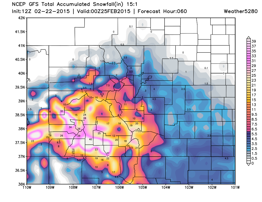
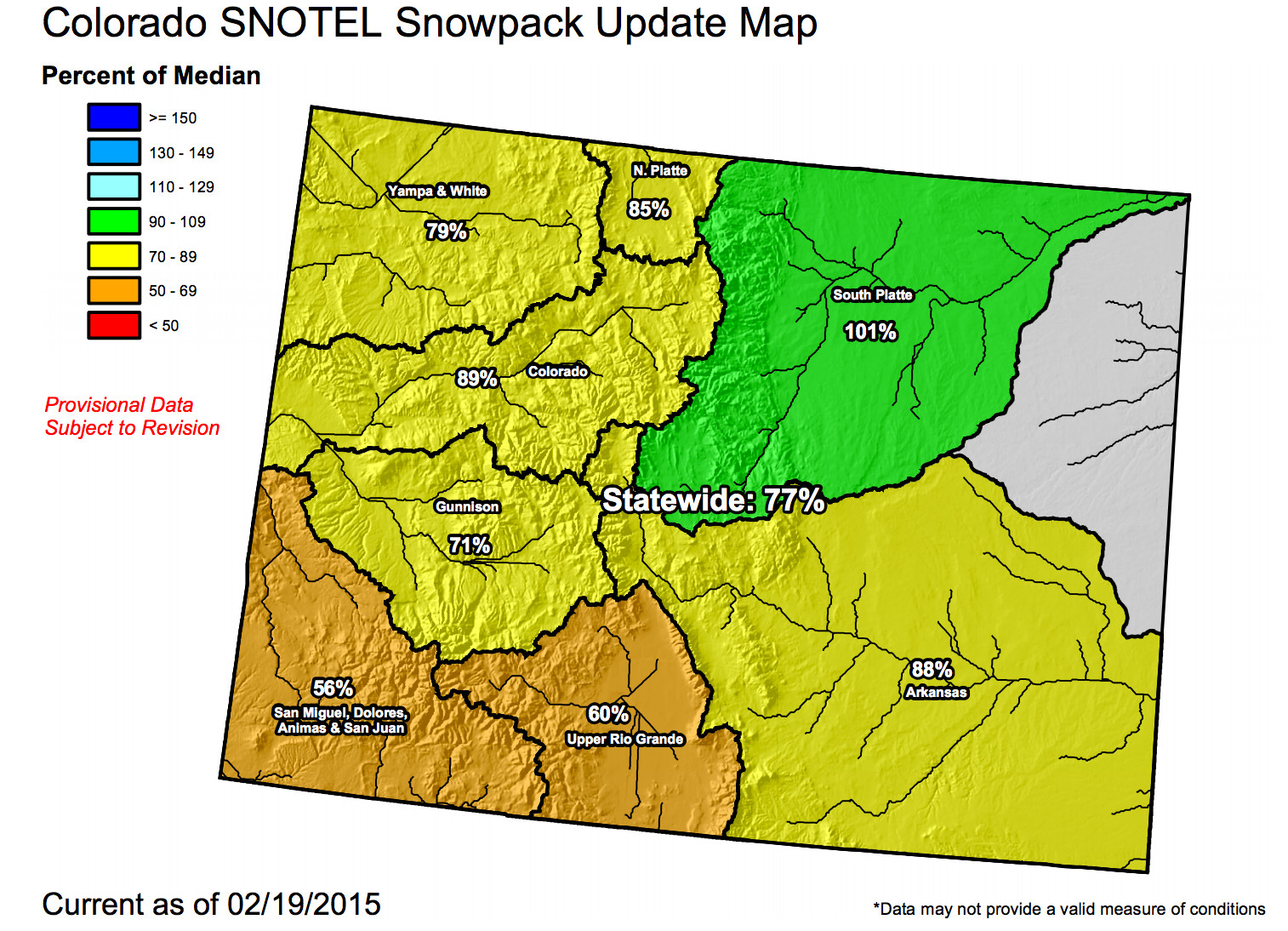
This is GREAT news considering this is the part of the state hurting most from poor snowpack.
Brief forecast
Winter will stick with us for awhile now as the pattern we've been discussing for some time settles in. Along with scattered snow showers through Monday morning, expect bitter cold temperatures across eastern Colorado as well. Highs will stay in the teens Sunday with overnight lows in the single digits. Not much warmer Monday, with highs climbing back into the 20s.
We get a brief break Tuesday before we watch our next system approach for Wednesday evening and Thursday. For now we'll introduce another chance for snow across eastern Colorado by Wednesday night, and address the details with this system in our next post.
No State of the Atmosphere today, but I think the state is pretty clear! Enjoy the snow and stay warm!