The State of the Atmosphere: Sunday, April 5, 2015

I flew out of Denver International Airport on Thursday afternoon in near whiteout conditions de-icing on the tarmac. This morning I landed back in Denver in full sun and mid 70s. Welcome April!
While not a huge storm, last week's system was certainly a change, and most did see some snow as forecast. While for many totals did 'bust', this was hopefully not surprising. For others, however, the storm certainly did not bust, with some northern Front Range mountain communities seeing >10" of snow, and the northeast corner of the state saw so much needed moisture. Notice the sharp cutoff of precipitation from north to south across eastern Colorado, something we covered extensively last week. Officially, Denver recorded 1.2" (closer to two downtown) of snow with this event with a forecast of 2 - 4" and a high BI of 8.

The week ahead for northeast Colorado looks much like what we've seen over the last three weeks now – a quiet, mild start, with potentially a cooler, wetter finish.
Rain and snow for California
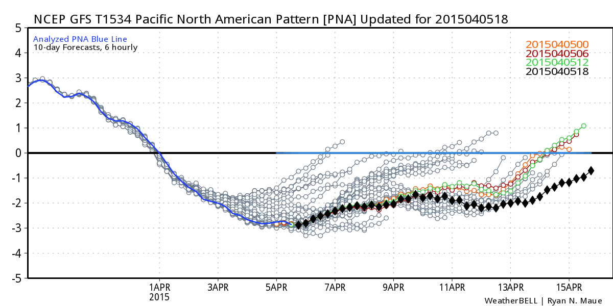
The PNA has gone negative which will support more troughing in the west over the next 10 to 15 days. This is part of the weather pattern shift we discussed last weekend which paved the way for last week's storm, and now for an even stronger trough to plow into the west coast this week. While there are certainly big questions how Colorado will fare over the next two weeks, the pattern no doubt is an active one.
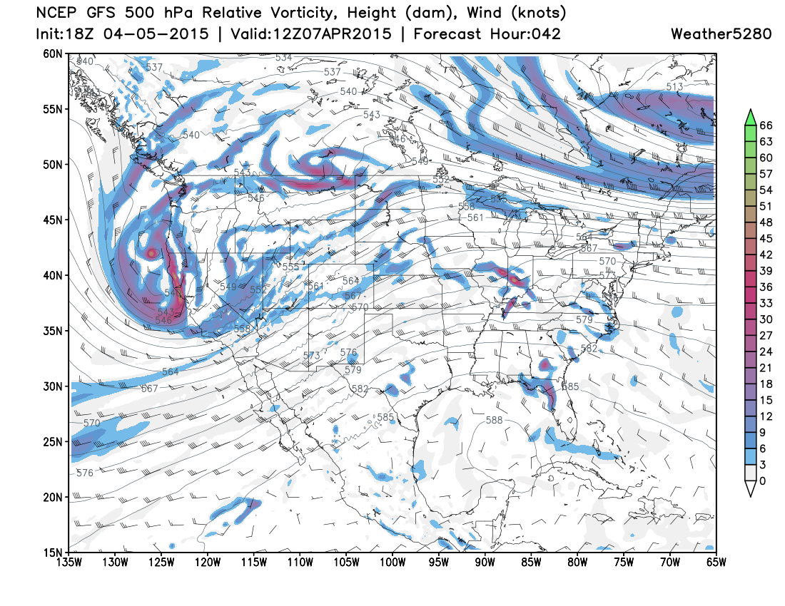
Our next system will begin moving into the west coast tonight bringing a period of much needed precipitation for northern and north-central California. This large upper level trough will come onshore Monday, and dig into the Great Basin by early Wednesday, before eventually tracking east across Colorado.
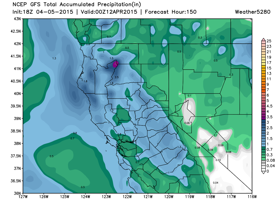
Several inches of precipitation forecast for the northern half of California... including some snow at higher elevations. Great news.
Rain and snow possible for Colorado too
There are big differences in the models in how this next system will progress across Colorado. Right now the EURO has been consistently deeper and slower with the upper level feature, while the GFS has trended toward a faster, more northern solution.
A compromise between the two would mean a cooler/wetter second half of the week, but not a huge weather maker for us. The GFS solution would mean very little precipitation for the Denver area, while the EURO would mean a good chance of rain and snow from late Wednesday through Thursday.
Despite the consistency we've seen in the EURO, I'm not all that thrilled about its solution yet. Looking at the JMA/CMC they look much more like the GFS, with the storm track staying too far north of Colorado for a significant rain/snow event across the metro area. That said, still lots of time for things to change, and the GFS itself hasn't been all that consistent over the last few days.
Given the overall pattern, and the fact we've had our eye on this system for over a week now, it certainly bears watching.
Severe weather
As the trough digs into Colorado Wednesday and eventually eastward, expect the severe weather threat across the central plains to increase. Right now it looks like both Wednesday and Thursday will feature a chance for severe thunderstorms, meaning hail, damaging wind, and tornadoes.
Related: Tornado Digest: As peak season begins, a severe weather ramp up is underway
Here is where the SPC is currently thinking the greatest threat for severe weather will occur on day 4 and 5, though we will likely see some fluctuation over the coming days as a clearer solution is agreed on with regard to the UL trough.
A lot to keep an eye on as we head into the first full week of April. We'll continue to monitor how our next system comes onshore and should expect to see some agreement start to form over the next 24 hours or so and be able to get a better handle on what impacts to expect for Colorado later this week.
For now plan on a quiet start to the week, but keep an eye on the forecast as we head toward the middle to second half of the week.