Weather5280's 2014-2015 Snow Season Forecast Review

We're just about there folks, the warm season is at the doorstep. May is Denver's 8th snowiest month and while it can produce big snowfall for Denver, we're hoping the Mother's Day storm just about puts a wrap to the season for lower elevations.
Denver's snow season runs from September through May, with a long-term average of 57.5" of snow seasonally. Of the nine months that have measurable snow on average in Denver, March leads the way with 11.5", while September is least snowiest with 1.1" on average. May typically records 1.7" of snow, this year Denver International Airport has recorded 4.0" for the month.
Barring any additional accumulating snowfall before June, Denver's 2014-2015 seasonal snowfall will end just above average with 57.8" of snow recorded at Denver International Airport through May 11th.
The long and the short of our forecast is, in pure numbers most of it worked out very well. While it certainly didn't feel like a snowy winter to many, compiling over an average snowfall season (all things considered) is really not too bad.
![]()
Winter 2014-15 Forecast Grade
The overall grade we'll give our winter season forecast is a B+. While there were certainly some hiccups, we came out at the end very near where out analogs put us way back in October. Near normal snowfall, a relatively quiet start, and a more active finish (March excluded). There were some issues with our outlook too, this to be sure, we'll break things down a bit below:
Snowfall: A
For our snowfall outlook we relied heavily on analogs. If you'll recall, Brian Bledsoe spent quite a bit of time last fall analyzing and discussing possible similar winters to this one.
One year that stood out specifically for snowfall was 1957/58. Both in our Winter Outlook Part Two, and again a month later in November, Brian outlined 1957/58 as the top analog.
Three things to note with this analog: 1) at 57.1" this is nearly exactly average snowfall for Denver, 2) 1957 was a back-loaded winter (more evenly distributed than this year, I'll address below), and 3) '57 ended with just 0.7" less snow from our 2014-15 total of 57.8" (through May 11). Not bad!
The image below shows our other top analogs as of October 2014. Three of the five saw near-normal snowfall, and nearly all were pretty lousy snow winters outside of a big snowfall event or period (hello Feb 2015).

For Colorado Springs the analogs generally produced above normal snowfall, and this was a theme we hit on frequently last fall. COS had a much better chance for above normal snowfall, and sure enough this panned out. The 30 year seasonal snowfall average for COS is 36.0" while the long-term average is 38.8". Through May 4, COS had recorded 46.5" for the 2014-15 season, with over 50" recorded across the northern portions of the city.
The only thing keeping this from being an A+ was the lack of delivery on our April storm for a big (and memorable) snowfall, and a below average March snowfall.
Temperatures: B-
Temperatures weren't quite as cooperative. While we did good job explaining the winter as-a-whole may be quite lack-luster, it's fair to say some of the periods of drier and warmer weather stuck around longer than a) we would have hoped for, and b) we had forecast.
There were essentially three cold-spells during the 2014-15 snowfall season: at the end of November, the end of December and beginning of January, and the second half of February. Much of the rest of winter was quite mild.
While we knew we'd see our fair share of warm spells given the positioning of the western ridge this winter, we had some reason to believe the near-average/below average line in the map below would be positioned a bit further west. This map shows the mean temperature anomaly (departure from normal) for most of December, January and February. Warm in the west, cold in the east.
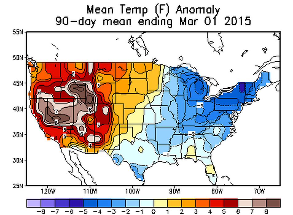
Eastern Colorado averaged from 1 to 2 degrees F above normal for this period, while western Colorado was notably warmer – extending west into the Great Basin.
"Late-show": B+
This one is trickier. While we saw a very snowy February, March put a very quick end to this. In April our pattern finally turned wet again, but then we were missing the cold. After the start to May we have experienced, and the Mother's Day snow, it's fair to say the late show has delivered for three out of the four months highlighted (Feb, April, May – not March).
Despite our forecast breaking down in March, we will end may with above normal snowfall for the last four months (Feb-May), with 34.6" recorded compared to 29.7" on average. Also despite a dry March, a snowy February, wet April, and already above average May will all work together to keep this period above normal for precipitation in Denver, fitting the forecast nicely.
While precipitation-wise we may end up closer to an A+ for "late-show", given how much of this will come in the form of non-frozen liquid, we've taken a pretty big hit in this category. We had one good chance at our anomalous big storm this season, but it just didn't quite pan out, bringing feet of snow to higher elevations, but coming in just a touch too warm for Denver.
Nevertheless, we saw record snowfall in February, above average precipitation in April, and now above average snowfall and precipitation in May, culminating to a pretty impressive 4 month period, and not a bad "late-show" in the end.
Statewide: B-
Unfortunately, when considering this snowfall season at a statewide level the numbers are pretty grim. Good for us in that our focus was not on the mountains, but bad in so many other ways. Despite not being the focal point of our winter forecast, I've deducted a few points here given two issues specifically.
Southeast Colorado. Oh how we've tried to get your precipitation over the last 12 months. While there has been drought improvement, we did think this winter would be a bit more forgiving overall. While what we've been preaching since last April remains true – overall drought conditions have improved for the Plains – it's not as far along in southeast Colorado as we had hoped. That said, no more currently no "Extreme" or "Exceptional" drought classifications statewide, which was not true a year ago. The pattern over the last few weeks has also been a big help in this part of the state, with the area finally seeing a good stretch of above normal precipitation.
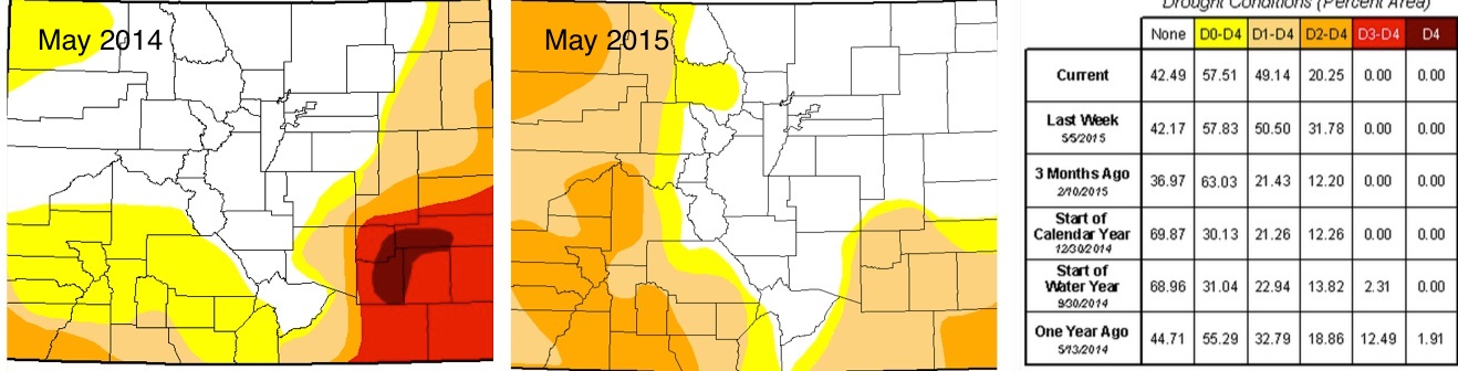
Western Colorado. What you'll also notice in the maps above, however, is the increase of D2-D4 (Severe Drought) across western Colorado. This due in large part to a crummy snowfall season for areas west of the Divide. While we hoped a late-season uptick in snowfall would gain some ground, this part of the state suffered from the same low-snow March Denver did, and never quite recovered.
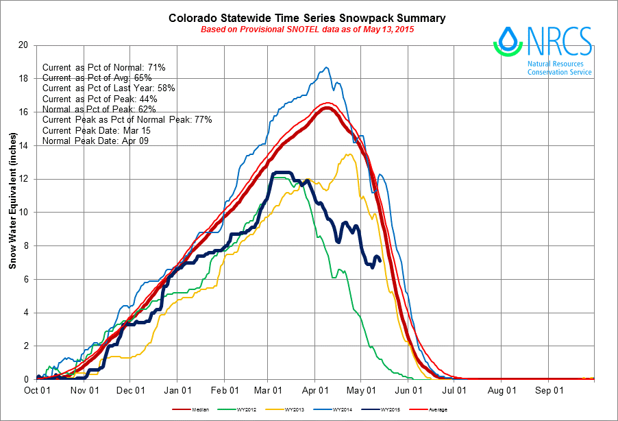
Taking a look at the latest snowpack summary from NRCS one how the recent snows have helped somewhat, but unfortunately peak was well below normal at the statewide level. As of May 13th, the statewide snowpack was at 77%, after peaking nearly a month early in early March.
Wrap
I wanted to get this out before June when snow will be completely off our radar. I hope you find our review fair, and if not, please let us know in the comments below, we always love to hear from you!
It's been quite a ride over the last few months, already looking forward to what next winter may hold.