The State of the Atmosphere: Sunday, June 28, 2015

A beautiful day with a handful of strong storms across the state to wrap-up the last weekend in what's been an eventful month of weather for the region. Despite most of Denver County seeing between 6 - 8" of precipitation this month, officially Denver has only logged 2.31" through the first 28 days of June at Denver International Airport where records are kept. At our station, one mile south of downtown, we've seen 7.53" so far this month. On average, Denver sees 1.98" of precipitation in June.
The latest NWS precipitation analysis tells the story well, though even it is too wet for DIA (~3.5" vs 2.31" actual). Nevertheless, take a look at the HUGE difference between the city of Denver (circled in black) and DIA (northeast of circle) over the last month.
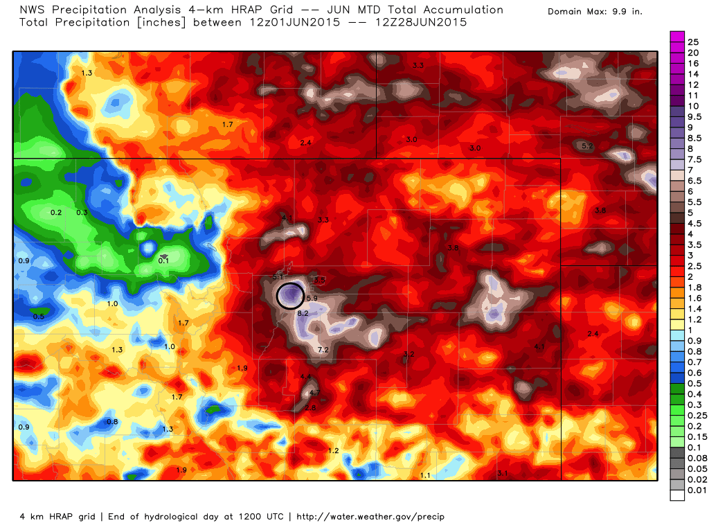
The differences are remarkable between DIA and virtually any other point within Denver County. As the National Weather Service in Boulder pointed out over the weekend, if the official weather station were still located at Stapleton, we'd be talking about block-buster, recording-setting May and June precipitation totals for Denver, but instead totals are above normal, but not dramatically so at 6.07". In fact, Stapleton has seen more precipitation in just May and June than DIA has seen all of this year!
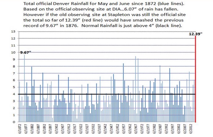
Related: It hasn't rained as much as you think it has in Denver (officially)
The week ahead
Like last week, storm chances over the coming week will generally increase as the week progresses. Storms over the next couple of days will be limited as the big ridge of high pressure over the West begins to break down, but holds on a bit longer. While storm chances won't be zero, they will be more isolated and scattered in nature through likely Tuesday, before increasing for the middle and latter half of the week.
There have been some pretty good inconsistencies between the models in recent days in where the heaviest precipitation over the next 10 days ends up. A few runs to end last week plastered northeast Colorado, while more recent runs favor southern areas more.
For now we'll go with greatest precipitation chances across the southern metro and along the Palmer Divide over the next week, as well as across the Front Range mountains. For Denver and the northern urban corridor it'll be more of a waiting game to see which days over the next week deliver. While storm chances will generally increase as the week progresses, nailing down the details remains tricky. As we saw last week, it only takes one storm to dramatically change the look of things for any given location.
Heading for July
As has been the theme this entire summer, no days will be completely free of storm chances over the next 10, and any storms that do develop will carry the potential to be strong, able to produce ample rain, and of course hail. With plenty of moisture around after several months of above average precipitation, this positive feedback loop will continue to produce until a substantial shift in our weather takes place.
Modeled precipitation totals over the next 10 days range from 0.25 to 3.5" across eastern Colorado, with even greater totals progged for portions of the Front Range and higher terrain across southern Colorado. With the average monthly precipitation for July being 2.16" for Denver, it's looking like we'll be picking up the next month right where June leaves off.
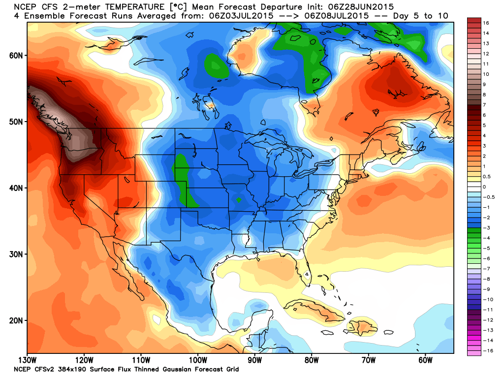
With the increase of moisture across the state as we head into July, and the potential for an even stormier period by the first full week of the month, expect temperatures to cool to at or below normal beyond Tuesday of this week. The latest CFSv2 model has temperatures from -2 to -4 degrees C below normal across eastern Colorado next week. While the CFS is known to struggle, it's actually done quite well overall this summer.
With July 4th just a few short days away we'll keep a close eye on things as the week progresses. Today's model runs are running a bit drier for the Denver area than they have shown in recent days for the 4th, but with PWAT values forecast to increase through the week, we certainly can't rule out some storms on the 4th at this juncture.
If you're not yet subscribed to Weather5280, now is a good time to do so with the Holiday weekend approaching.