Sunday Night Update: Tweaks to Snowfall Forecast; NWS Issues Blizzard Watch for Denver

For those following along closely, it’s been a big night in model land as all of the 00z models that have come in have increased snow totals for Denver. This is due in part to them moving the precipitation shield a bit further north than previous runs, and extending the duration just enough. The overall look remains fairly similar, however, with a sharp north/south gradient for heavy snowfall – but whether that lands over Denver, just to south of Denver, or just north of Denver remains in question. As we discussed earlier, pinpointing where this line will be will remain difficult, likely into tomorrow.
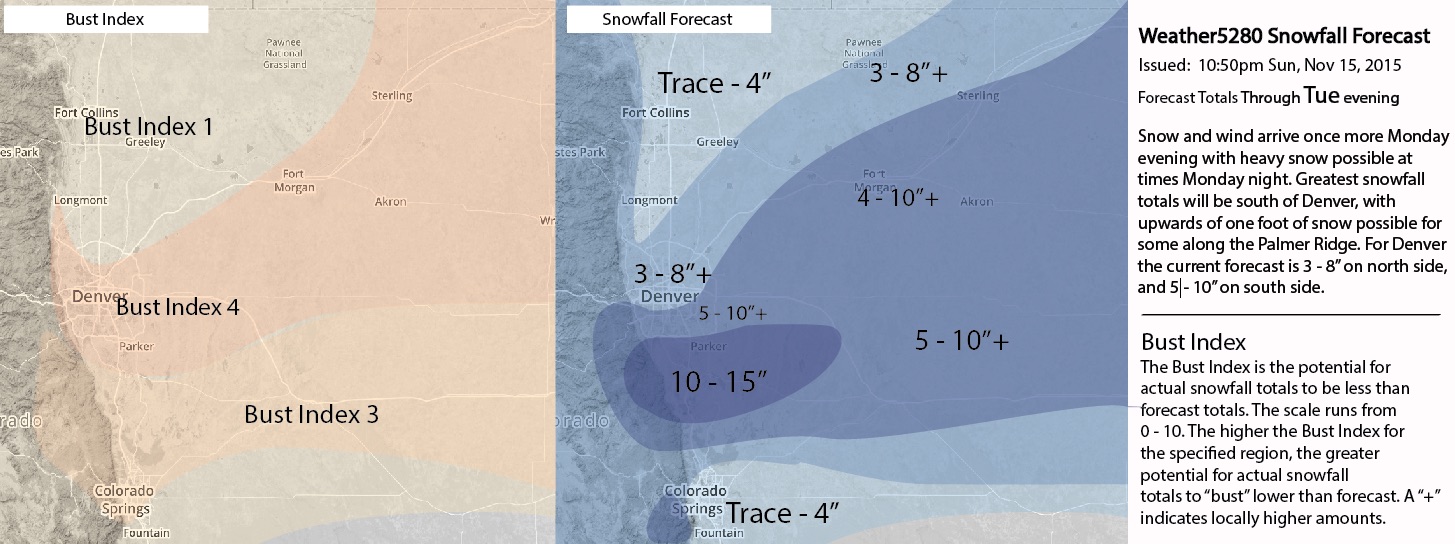
With better consensus between the models this evening for Denver, the National Weather Service has extended the Blizzard Watch to include Denver proper. Winds will increase overnight Monday into Tuesday, with gusts to 45mph, causing reduced visibility and poor travel conditions. Their current forecast for Denver is 4 - 10", which is up substantially from earlier today. Remember, a blizzard watch is not about the amount of snow, but rather the effect of strong winds on the snow. Travel will not be advised south and east of Denver late Monday night, as conditions across the Palmer Divide deteriorate.
For the time being we will stick with 3 - 8" for downtown Denver and the north side of town until we feel a bit more confident in moving the heavier snowfall northward. We will up totals for the southern Denver area from 4 - 8" to 5 - 10", with 10 - 15" across the Palmer Divide. This has been our favored area all weekend, so we'll stick with that. We have lowered the Bust Index for Denver from a 6 to 4. To the south, we have 2 - 6" for Colorado Springs, with 10 - 16" for Monument. Lastly, we've extended the area for 4 - 10" northward across the Plains.
We will continue to monitor our snowfall forecast overnight and Monday, and make additional changes as needed. Rain showers will begin over the eastern Plains by Monday afternoon, with the best chance of snow moving into the area Monday evening and late overnight into Tuesday morning.
Overall we see no huge changes at this time, but our confidence for the lower bounds of our 3-8” forecast for Denver, particularly, have increased. We’d like to see how things progress overnight, and may make some additional adjustments tomorrow if need be. Overall, the biggest change is increasing totals for the Palmer Divide, as our confidence is greatest there. I suspect some of the models going crazy at 00z may well adjust back down on Monday.
Given the track record of this system, and the major issues in the modeling behind it, I’ll continue to stress there is still a reasonable amount of uncertainty with this forecast as we head into Monday. These lows can be big snow producers if all lines up right, but can also seriously bust too. Add to that some very sharp gradients in heavy snowfall over just a few short miles, and someone is likely to feel left out. Let's see how things look tomorrow. Quite frankly, if some of these models are right, we'll be adjusting more snowfall totals up in the morning. Maybe 06z will bring some calm.