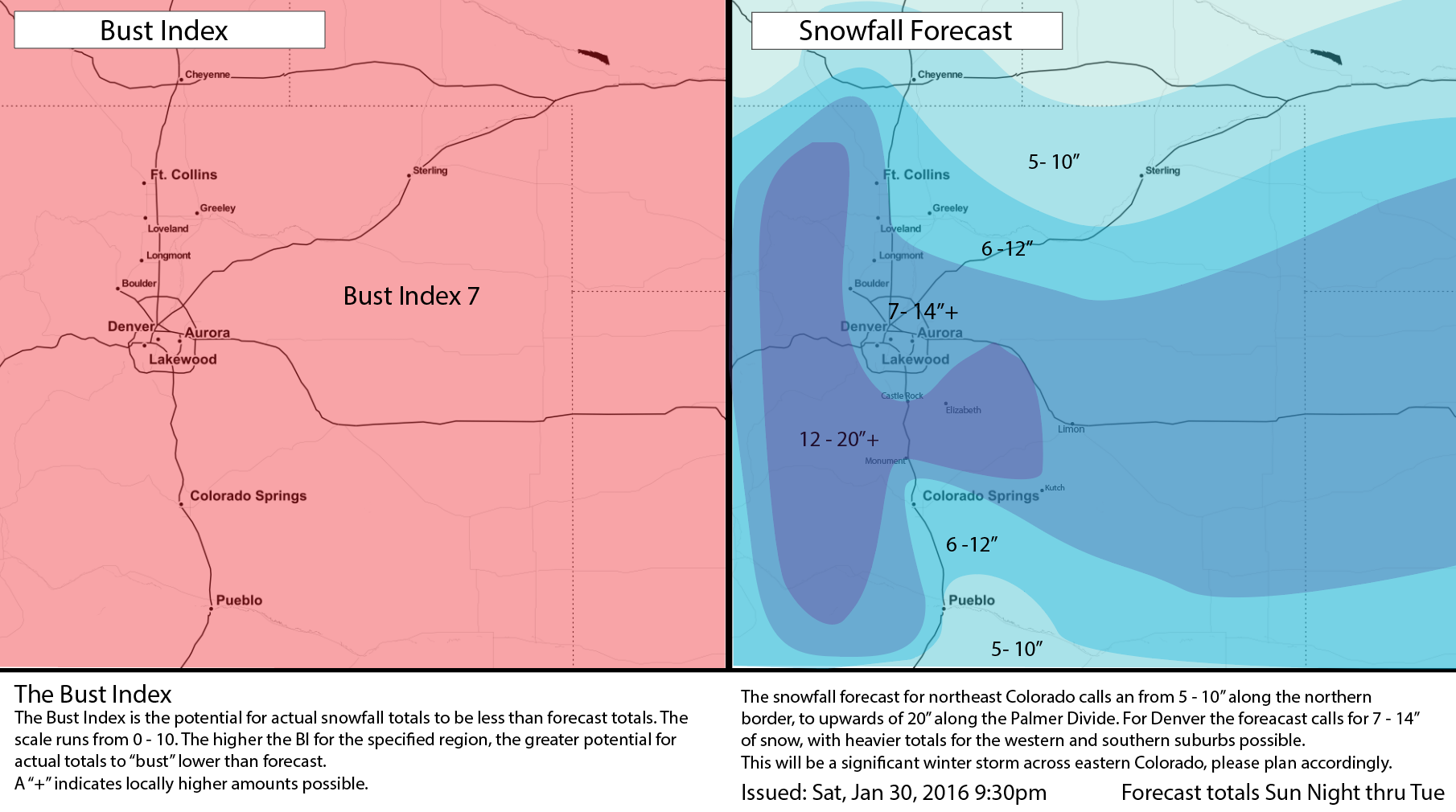
Saturday Evening Update: Initial Snowfall Forecast

What a day. What a week. We've so enjoyed you joining us this week in tracking our winter storm due in Sunday night and lingering into Tuesday across eastern Colorado.
As we write this update, snowfall is falling across the urban corridor and northeast Plains. This is a nice preview of what's to come over the next several days, as snow becomes more widespread late Sunday night and continues off and on into Tuesday. A Winter Storm Watch has been issued for all of eastern Colorado, and goes into effect late Sunday night. Barring any big changes over the next 12 hours, we'd expect that Watch to be upgraded to a Warning for many sometime Sunday.
Why now snowfall forecast yet?
So far we have not issued an official snowfall forecast. The reasoning for this is twofold, at least. One is, we've been trying to limit confusion between tonight's snowfall and what we're tracking for Sunday night - Tuesday. The second is, that despite what models are producing for snowfall, we continue to have some concerns in their realities. Not to say they are wrong, but if we wanted to issue a forecast based on solely model QPF we could have done so last Monday – models have been saying big time snow for a week now.
Big questions
We have several big questions still nagging us this evening, most surrounding upper level features associated with this system. For example, the 00z NAM which just came in on paper looks great for a bit snowfall across northeast Colorado – while at the same time its upper level forecast looks far more questionable as compared to previous runs. You've heard us talk about a closed off, negatively tilted trough all week... but in tonight's run, calling it so is pushing it. So the question is – given this scenario is there support for the snowfall totals it's producing? In some locations probably, but we get uneasy about how widespread these totals are if this thing doesn't got negative tilt.
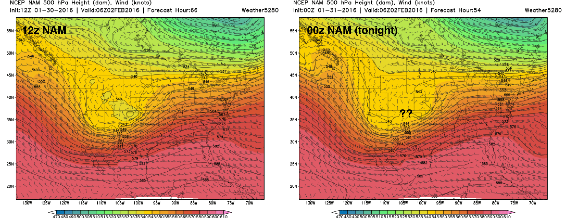
Assuming the NAM is goofing, our other concerns remain the same as they have all week. The location/placement of the low as it eventually tracks east along (near) the southern Colorado border.
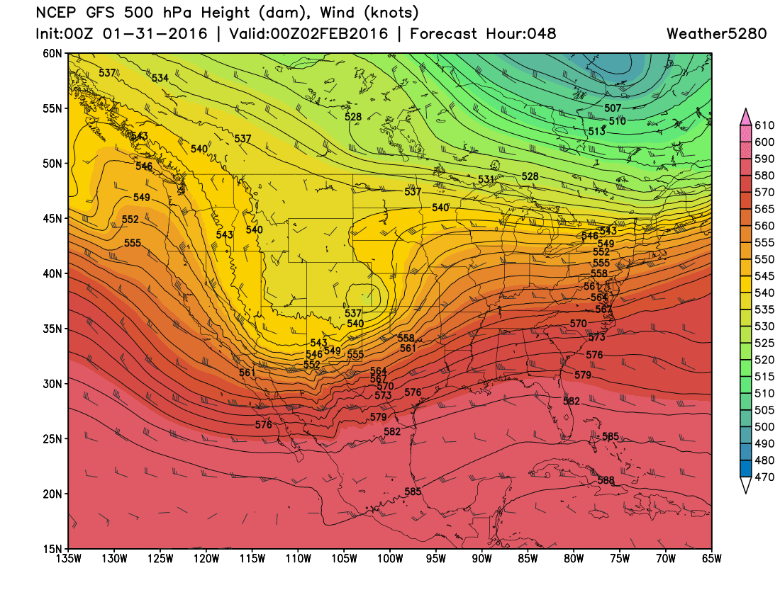
The GFS has moved north with its placement, and thus its snowfall too. This model has remained fairly consistent throughout the past few runs and has kept snow totals on the higher side for Denver. Given a GFS solution, southeast Colorado would miss the heavy snowfall for the most part... but certainly looks better tonight at 500mb than the NAM. Tongiht's Canadian, still favors a more southern solution, but looks great at 500mb. We'll see what the EURO looks like in another hour or so.
So, as we issue our initial snowfall forecast... here are our caveats:
- In sampling we trust. As Brian discussed earlier today, we're still waiting for all models to come in with better sampled initialization as our system comes on shore in the west. We expect there may be some fluctuation yet in how models are handling both the track of our Low, and QPF over the next run or so.
- 0z models continue to forecast high snowfall totals, and despite some red flags on the NAM tonight, consistency counts for something. If nothing else, a prolonged period of light snowfall will hopefully get us to our totals.
- For those in Colorado Springs and points southeast... pay close attention to forecast going forward. IF latest runs are correct, the heaviest snowfall may end up north of you with a sharp north wind killing snowfall too soon. If GFS is correct, the numbers we have below will need to be lowered for COS tomorrow.
- We trust that you all understand that these numbers may change between now and tomorrow night. So please, check back with us – often – and understand that these are preliminary numbers, not necessarily our final snowfall forecast.
- Bust Index is high for the time being.
- What did we miss?
Get some rest, we'll see you tomorrow!