The State of the Atmosphere: Sunday, March 20, 2016

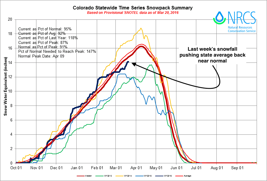
While meteorological spring began March 1st, today marks the start of astronomical spring and an early vernal equinox. With the recent time change, it certainly has been feeling more and more like spring in recent days, despite last week's snow. Sunsets now are after 7 pm, and there was light in the sky as late as 8 pm over the last several nights.
The weather, however, will be wintry at times over the coming weeks, as is to be expected during springtime in the Rockies. As Brian Bledsoe discussed yesterday we'll be tracking several systems over the next 10 to 15 days, which may bring more rain and snow to the state before the month is over.
The week ahead
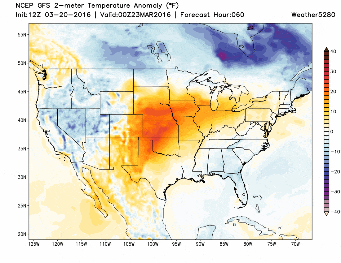
The week ahead starts warm. But after a quick return to spring-like temperatures, we'll be tracking our next weather maker due in Wednesday that may once again bring rain and snow to eastern Colorado.
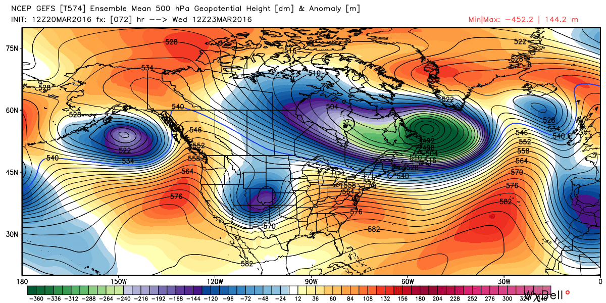
So, this is where we'll focus our attention. An upper-level trough will swing through the region early Wednesday and on into Thursday. Over recent days, guidance has placed the mid level low a bit too far north to be favorable for snowfall in and along the Front Range, and instead has focused the rain and snow further east across the Plains. In the last 24 hours or so we've seen some tendency to bring that Low a bit further south – which if the trend continues, would put Denver in a better location to see rain and snow.
In either scenario, Wednesday will feature an abrupt change to the warmth we see Monday and Tuesday. This next system is almost certain to deliver some wintry conditions somewhere across eastern Colorado, and will be accompanied by strong winds and much colder temperatures.
As for snow... there's still quite a spread in solutions, despite general agreement on a strong trough affecting the area by mid week. The latest runs of the EURO track the low a bit further south than the GFS/CMC and, therefore, produces a big-time snow across the urban corridor and northeast Plains. The Canadian is also south of the GFS with the positioning of the low, and it too produces snow/better upslope for the metro area and adjacent foothills. The GFS has been further north today, but has shown quite a bit of run-to-run inconsistencies in how deep it wants to dig the trough. If the current GFS solution verifies, the downsloping flow would likely limit rain and snow for Denver and communities in and along the foothills, with a better chance for rain/snow east across the Plains.
Which solution will verify is a bit tricky to tell at this point. In the end, we're talking about a difference of a few hundred miles having big impacts on how this storm ends up taking shape for northeast Colorado, and where/whether the low can close off in time before getting too far east. If you're hoping for another snowfall along the Front Range, lean on a more southern, deeper solution.
While the GFS produces a surface low a bit too far north to favor heavy snowfall in Denver Wednesday/Thursday, the storm itself looks impressive. Expect difficult travel conditions across the central high Plains Wednesday and Thursday with rain, snow and strong winds producing blizzard conditions at times.
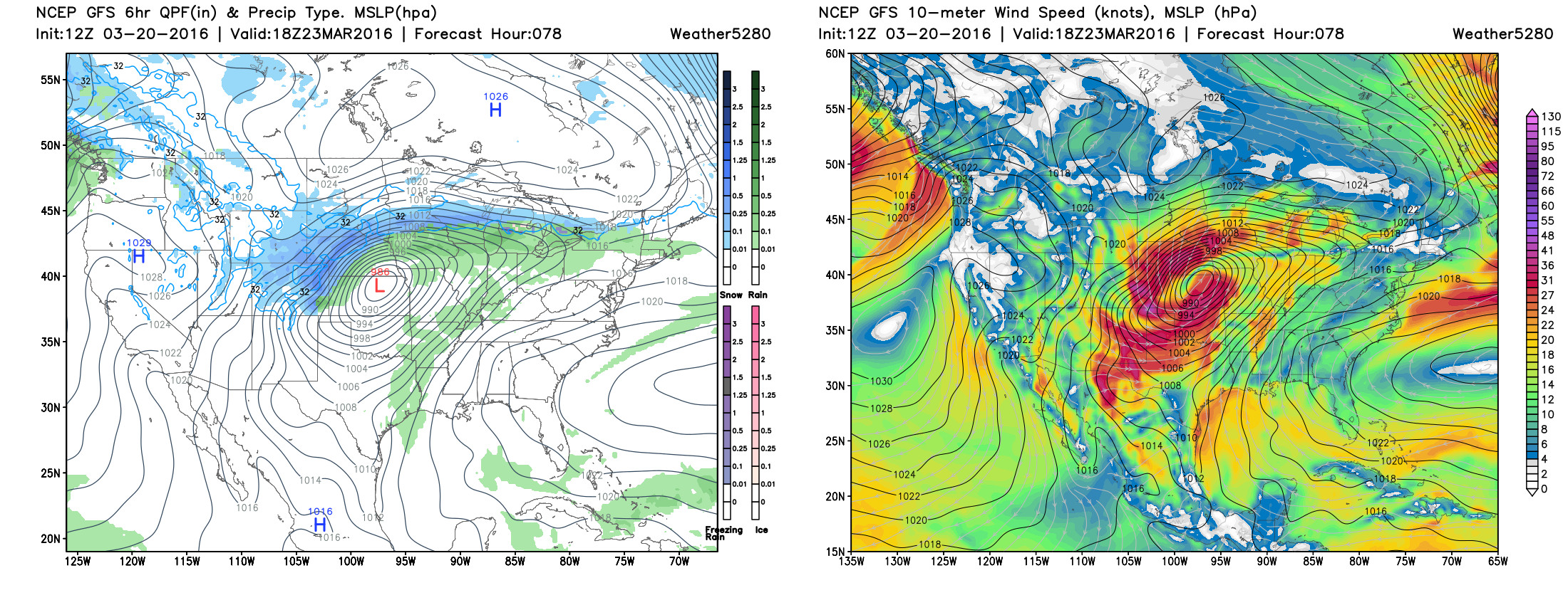
For now, the EURO deterministic model is snowiest for the Denver area with this midweek system, while the GFS/CMC operational are less so. Even the EURO favors the heaviest snowfall from Denver east – so we'll have to keep an eye on the eventual track to see how things line up for areas along and west of I-25. Still enough uncertainty not to go full bore on snow for us in town here, but plenty of interest to keep an eye on this thing over the next few days.
If we miss on the Wednesday/Thursday snow it looks like we'll see another system move through the region for the weekend. We'll go ahead and address this in a future post, however.
Overall, runs today look pretty wintry. While the snowfall the EURO deterministic is outputting for the next 10 days is questionable, the pattern does look reasonably active. If we can get a storm or two to stick – we should have enough cold air available with this pattern that we could end the month strong. Generally speaking, this is a rather unconventional pattern for us to see big snowfall events along the Front Range, as the northwest flow often limits a system's ability to get its act together fast enough. This Wednesday remains intriguing giving several models are showing the low deepening and closing off, but it's far from a done deal. As we saw last week, we can do quite well with snow given the right ingredients lining up just right. As always, the devil is in the details.
Stay tuned! And subscribe to Weather5280 if you aren't already!