Monday PM Update: Midweek Storm Update

March will end much snowier than average, and the total may grow before the month actually ends. At 18.4", March 2016 is currently the 27th snowiest March on record for Denver, dating back to 1881.
Below are the top 10 snowiest Marches on record, as you can see, we have a ways to go to crack the top 10 this year:
- 35.2" in 2003
- 32.5" in 1944
- 31.3" in 1897
- 30.5" in 1983
- 29.2" in 1961
- 26.8" in 1959
- 25.7" in 1923
- 25.2" in 1952
- 24.8" in 1929
- 24" in 1981
The next system is moving across the Western U.S. and will bring its impact to Colorado and Wyoming Tuesday through Thursday. Right now it appears that the biggest snowfall impact will be across southern Wyoming and in the Colorado mountains.
Denver and the Front Range will likely come away with up to a few inches of snow. There may also be rain to start with and that will be Tuesday into Tuesday evening. Only an isolated shower or two is possible late Monday.
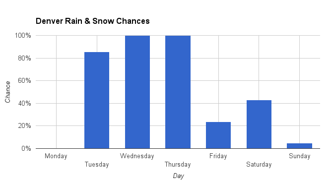
Snow chances will climb late Tuesday through Wednesday and some additional snow will be possible Thursday.
Through Monday morning, modeling from 3 of the global models kept Denver's snowfall in the Trace to 4" range across the city. Some higher totals to the west and south in Boulder, Douglas, and Jefferson Counties and to the north across Southern Wyoming.
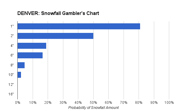
For Denver (DIA) here's the snowfall gambler's chart for the total snow coming in. Note the 50/50 point in probabilities 2".
Unless the storm track moves south, the heaviest snowfall will stay north of the metro areas. With that, this March is not likely to break into the snowiest Marches on record, as it looks right now.
We will keep you posted on any track changes in our forecast to be published Tuesday, including projected snowfall amounts for your area.