The State of the Atmosphere: Sunday, January 8th, 2017

Last week's snowfall and deep freeze are almost a distant memory across the metro area as warm temperatures and snow-eating wind has arrived across the lower Front Range.
Denver's official 4.1" on the week pushed us ever so closer to our average snowfall amount for the season, now sitting at 15.5" since September, with roughly 22" being an average season to date. Meanwhile, the mountains have been cruising to well above average in the past few weeks. Total Colorado snowpack is shown here:
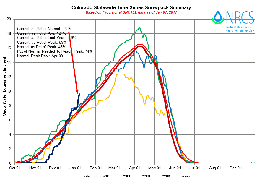
This season's snowfall started slower than any of the past 32 years and yet the recent snowfall has been accumulating faster than anything we've seen in more than 32 years. Insider members can read more on Colorado's snow and water levels here.
Snowfall this week favors mountains, an eye on late week for plains
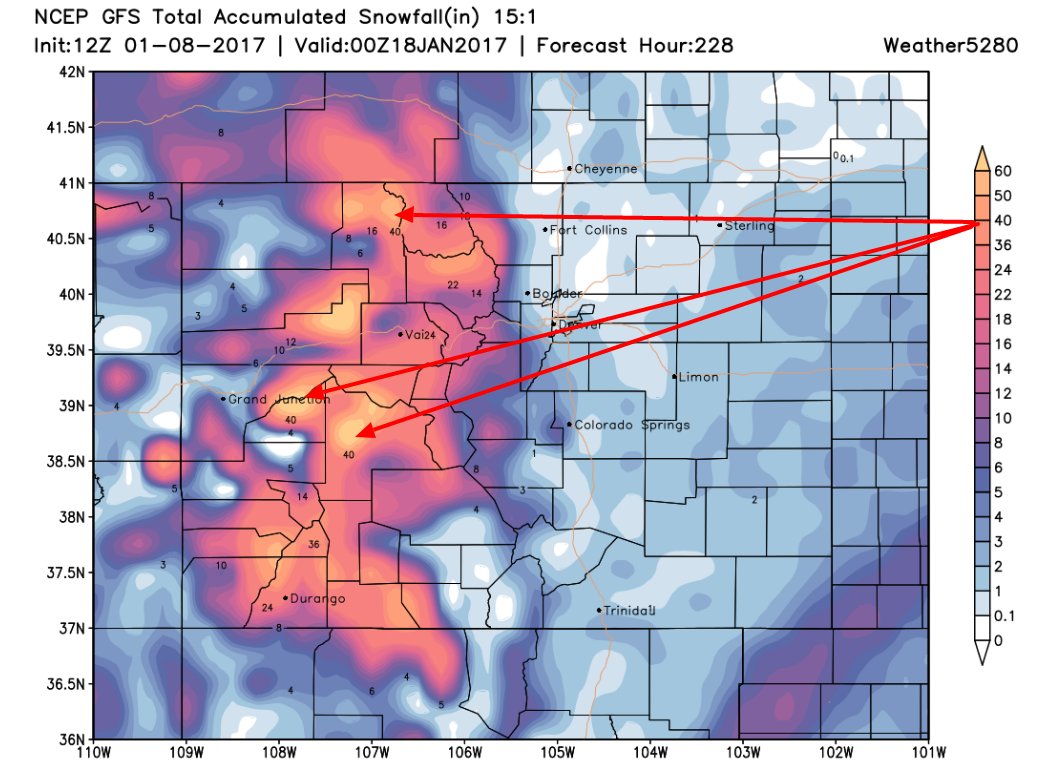
Another round(s) of heavy snowfall will hit the mountains this week. Some ranges will hit 30-40" or more. This is coming from a pattern that favors a westerly flow, which is to imply that those slopes facing west and northwest will come away with the most snowfall.
This pattern does not favor a lot of moisture for the metro areas or the plains, at least through the first two-thirds of the week.
Throughout the course of the week, we will see this prevailing wind flow 'kink' twice – Monday and Tuesday and toward the end of the week. Each 'kink', we call a trough, will be the main focus of heaviest snowfall in the mountains.
Both troughs will increase Denver's snow chances, but only slightly – the first especially. This one will be Monday night with the second arriving late week, by Friday or so (and possibly not until the weekend). For now, the metro area chances for snow with both are low, but if you're to watch either of them... it'd likely be the second.
With the second we've some tendency for models to bring a more favorable setup for snow across eastern Colorado, but the eventual track of the low remains VERY uncertain. At this time general consensus is to bring the low too far south for northeast Colorado to get in the action, but this could mean another good snow further southeast. Of course, should that track change (and the EURO is hinting at that today), our snow chances in Denver would increase for later this week and this weekend. Something to watch.
Here's the snowfall forecast made by one model, the GFS, through week's end:
Got wind?
The previously mentioned troughs will create strong wind. The foothills and mountains are subject to high wind warnings with 75 to 90mph wind gusts possible.
For the city's side of the mountains, this wind will be gusting (20-50mph) from a westerly direction Monday. This will result in a very warm day with a lot of snowmelt. A warm, snow-eating wind is referred to as a "Chinook".
The wind in the mountains will create blowing snow and reduced visibility for travel. The avalanche danger will also remain significant.
Unseasonal warmth
Keep in mind that a normal high for Denver is in the lower 40s...we will be above that most of the upcoming week.
For the eastern plains and metro areas, this week's prevailing wind flow - westerly - will bring very warm temperatures to the plains. Monday could push into the 60s for many of us. Tuesday through Thursday in the 40s and 50s. Friday may cool back below normal into the 30s with the arrival of that second, and stronger, trough.
Next weekend remains a bit uncertain with the arrival of that second, stronger trough. Should it's track become more favorable for snow across eastern Colorado we'll be talking another storm and chilly temperatures... if it stays south, we'll see a brief cooling, followed by another warming trend. Stay tuned!