Tuesday PM Update: One Eye on The Weekend

Highs Monday climbed into the mid 60s in Denver with strong downsloping winds wreaking havoc up and down the Front Range. Meanwhile, heavy snow continues to hammer mountain resorts with more on the way through the remainder of the week, with more wind for the Front Range into Wednesday.
As we discussed in this week's State of the Atmosphere uncertainty begins creeping into the picture as we head toward the weekend. A potent upper level low will become cutoff from the main flow and dive deep into the southwest. By Saturday it starts to move northeast out of Arizona... and it's eventual track will have big implications on our weather across eastern Colorado later Saturday and on into Sunday.
Cutoff lows are incredible difficult to forecast at range. Where they go, how slow (or fast the will move) etc is a great challenge for numerical weather models. With that, we've seen a HUGE spread in potential outcomes being forecast over the last several days... from clear skies and sunny across eastern Colorado, to a big southeast Colorado storm... to heavy snow across all of eastern Colorado by Sunday.
Today enough ensemble members are looking a bit more favorable for snow across much of eastern Colorado that we thought an update was prudent. That said... the uncertainty here cannot be stressed enough.
If we look at the forecast trend over the last days... we see some interesting things, however. Take a look at the forecast from two days ago. There's a big dip you can see in all the models (operational and ensemble comparisons), but only one, the EURO, had a tightly wound low over southeast Colorado (middle graphic on top), and it was the only model producing snow for us at the time too.
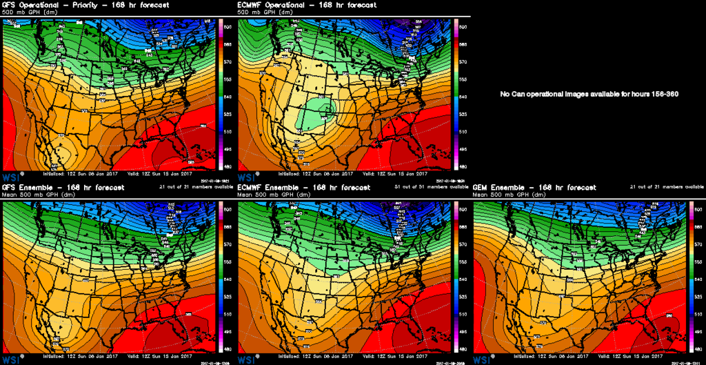
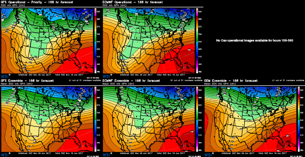
By yesterday, we saw a very progressive look to the modeling, with huge ensemble spreads in solutions. We also saw most of the models tracking the low too far south and east of Colorado to have much impact, even across southeast Colorado.
In the last 24 hours, we've seen this change again...
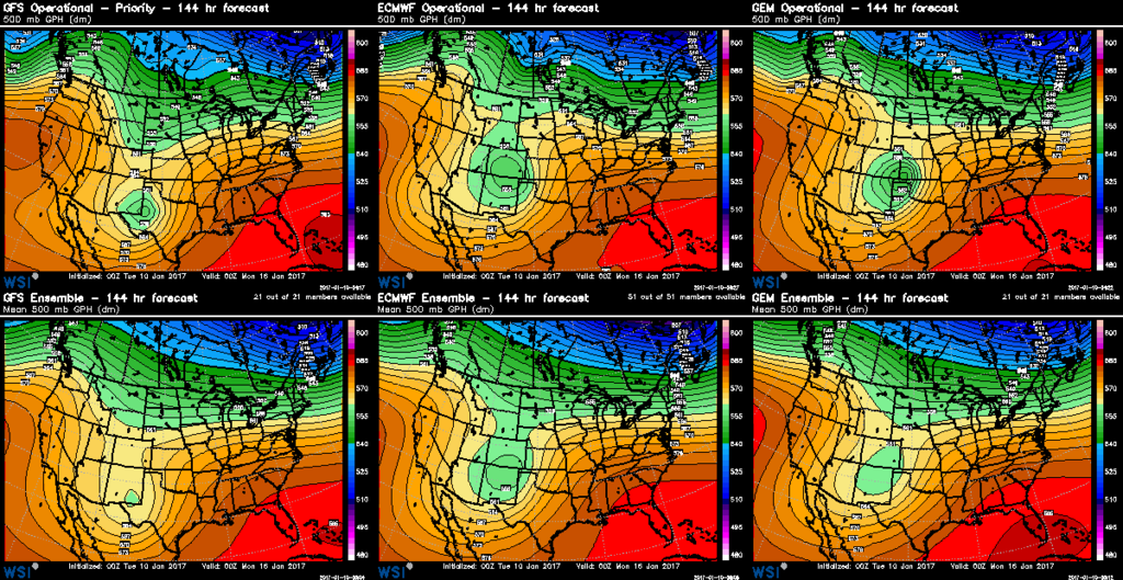
Note that there's much better agreement on this low closing off and strengthening somewhere south/southeast of Colorado. We also see a tendency to move the low a bit further north... right through southeast Colorado then north along the Colorado/Kansas border Sunday and on into Monday. The green blobs over southeast Colorado/New Mexico/Texas are what you're looking for here. The GFS (furthest left) remains further south than the EURO and GEM, and less favorable for snow across northeast Colorado, while today's operational EURO and GEM would have the potential to produce a strong winter storm.
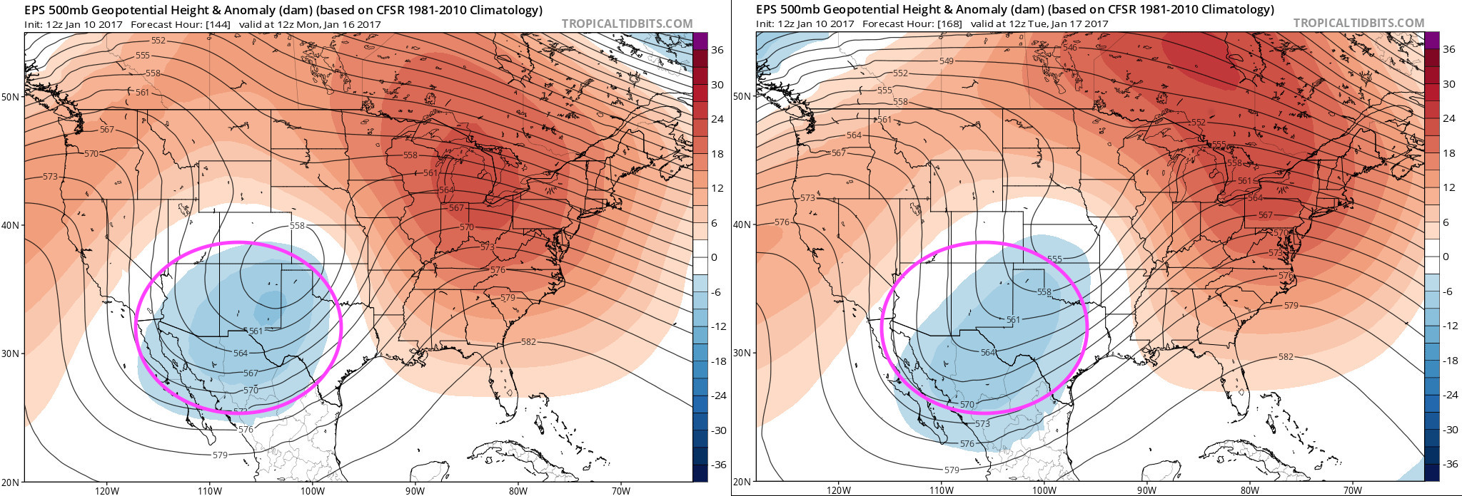
This thing certainly bears watching... It's hard for me to get too excited about it up north in the Denver area given how far south ALL modeling takes it before it ejects northeast. This typically isn't handled very well in the modeling, and we often will see these Lows end up too far south for us, unable to cruise north as modeling is suggesting today. We also see modeling stringing out the energy a bit, living quite a bit south, even as the main low may track north (circled pink below). This should also leave some pause if you start seeing snow maps flying around later today for Denver.
That said, there have been quite a few runs now from various models showing the more snowy solution for northeast Colorado that it seems worthy of keeping an eye on. Also, there was some expectation that models would correct north with this thing as compared to a few days ago... and sure enough they have.
With that here's roughly what we're looking at for the Friday - Monday timeframe. Snow, rain, sleet... you name it will be possible across northern New Mexico, the Texas and Oklahoma Panhandles initially, with the potential for that wintry precipitation to move north Saturday into Sunday.
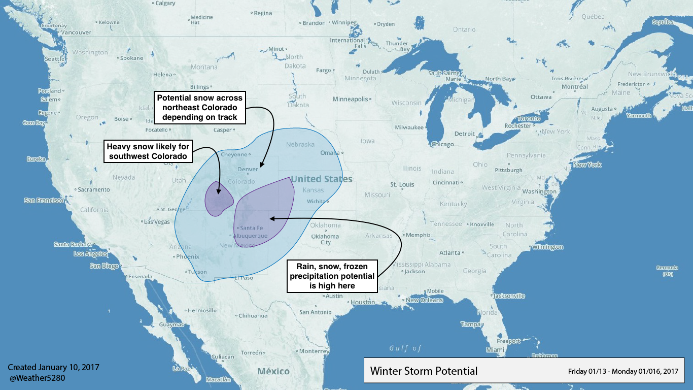
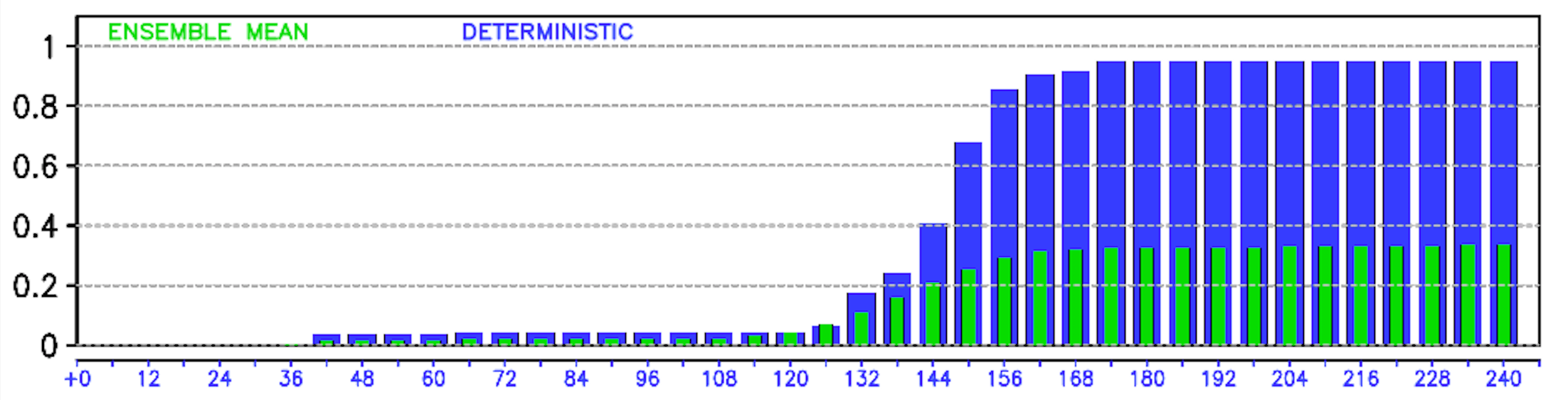
Biggest question at this point is likely how far north this low ends up tracking, and with it how far north the heavier precipitation is able to make it. Models LOVE to latch on to huge moisture north (as they have today), then back off when they realize it just won't quite make it north of the Palmer (Denver). The EURO ensemble mean shows this uncertainty well, forecasting ~0.3" liquid for Denver (I'll take it), but nearly 1" (!) from its deterministic run:
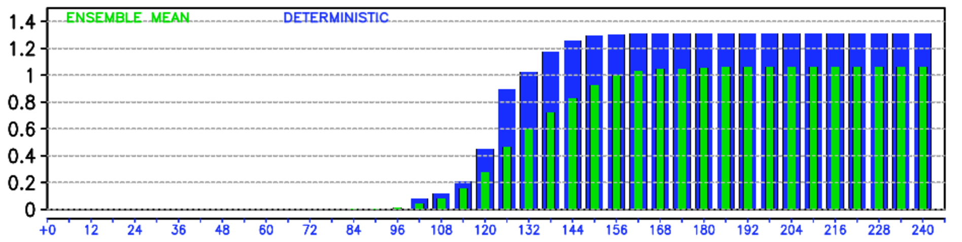
Further southeast across Colorado we see not only the spread is much smaller (better agreement), but also the mean is much wetter. Here's the EURO precipitation forecast for Lamar, CO for the same period:
In short... If you live in the Denver area or across northeast Colorado, keep an eye on the weekend forecast, but it's not a done deal. If you live across southeast Colorado, current forecast modeling is much more favorable for some beneficial moisture here (both in the form of rain and snow), but still PLENTY of time for that to change.