Late Week Storm Update and Initial Snowfall Forecast

The storm system we've been tracking as part of a larger shift in the stubborn weather pattern that has kept us high and dry for so many weeks continues to take shape today. The large trough is set to move into the west coast today, then track across Arizona late tonight and Thursday, before eventually moving into the Four Corners and southern Colorado Thursday evening.
The animation below shows this progression. Look for the areas of blue originating over southern California, then becoming more tightly knit and 'closed off' as it tracks into eastern Colorado:
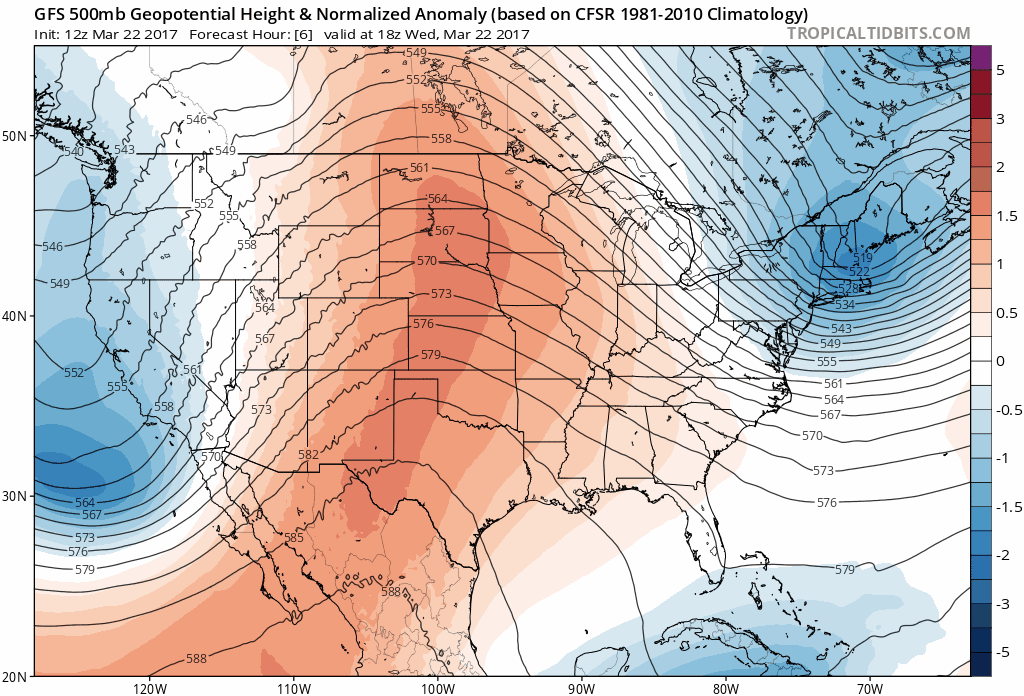
This is a pretty good track for us to see moisture around here, especially along the Palmer Divide extending east across the plains.
While we've seen some flipping and flopping from model QPF (precipitation) forecasts since our update yesterday, the 500mb track of the storm has been pretty darn consistent.
This lends to good confidence (barring any changes tonight) in a large area of rain and snow for the region Thursday night and Friday. Welcome news indeed.
Forecast at a glance
Thursday will feature another very warm day across northeast Colorado ahead of this system. Winds will also be on the increase, which will mean another day of heightened fire danger for us, prompting the National Weather Service to issue a Red Flag Warning for portions of the plains Thursday.
By Thursday afternoon we'll start to feel the impacts of this system, mainly in the form of wind and the development of scattered storms across the plains.
Temperatures will drop into the 30s overnight Thursday into Friday for Denver, with the chance for rain (and rain mixed with snow) increasing into Friday morning.
The best precipitation at this time is expected early Friday morning, before decreasing during the day Friday. This is when we expect the heaviest snow to fall along the Palmer Divide, and potentially see some changeover to snow in Denver as well.
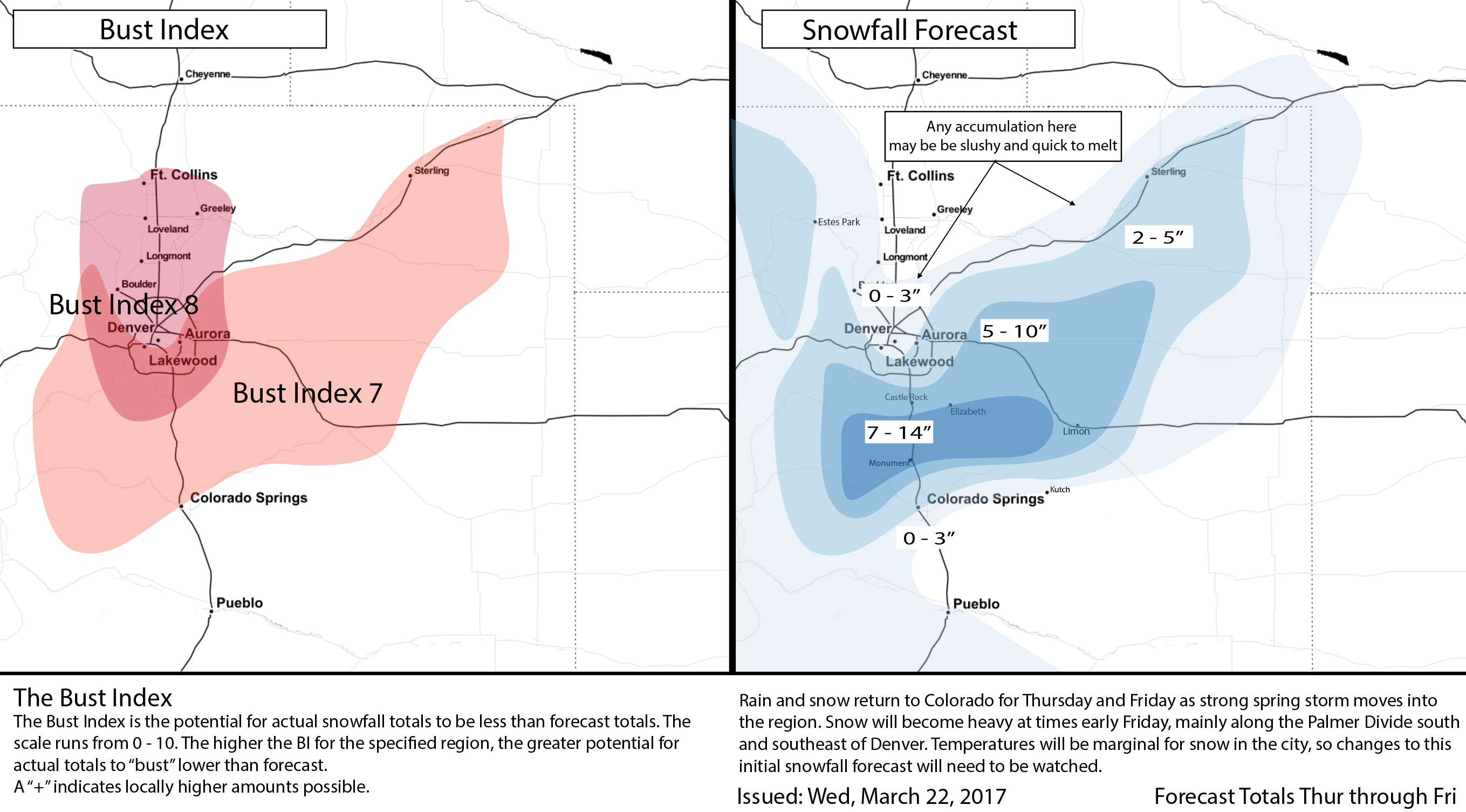
For snow, expect the heaviest snowfall to occur at higher elevations west, south, and southeast of Denver. While much of the snow will melt on contact initially, and compact over time, we do think some areas will see some pretty good accumulation from this event, mainly along the Palmer Divide between Denver and Colorado Springs. In Denver, while we may see some accumulation if temperatures cool enough, it'll be a slushy wet snow, and likely won't stick around for long.
Areas of concern
Despite very good consistency in the modeling around the track of the 500mb low, there's still some considerable differences in model QPF, and where exactly the heaviest precipitation ends up.
We know there will be a very sharp gradient from northwest to southeast across Denver of less precipitation to more. The question is, where exactly does that gradient end up? A shift of about 15 miles in either direction will have HUGE impacts on our forecast.
To help illustrate this, take a look at the 12z 3km NAM. It's got about 0.6" of liquid forecast for DIA, but just 0.1" for downtown Denver. For Monument and points east and northeast, it's forecasting of an inch of liquid. As you can see, if there's a slight shift west with that main precip shield, we get a far more impactful storm in Denver. A shift 15 miles east... it could dump rain/snow at DIA, while we get virtually NOTHING in Denver. Notice the lack of QPF over much of Larimer, Weld, and Boulder counties since they are under the influence of downsloping off the Cheyenne Ridge.
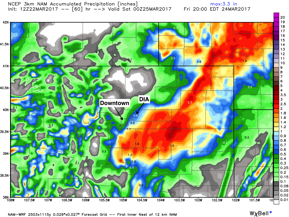
The 12km NAM has been the most concerning in this respect, with its 12z run pretty much missing Denver. We saw it recover a bit for Denver at 18z, while the GFS went the other direction with largely a precipitation miss for Denver.
These back-and-forths are nerve wracking, but expected.
Again, we think the consistency at 500mb has been more important with this forecast, and that modeled QPF will continue to jump around over the next 24 hours or so as its wont to do. A concern, but for now, we prefer a wetter solution for the metro area. If a trend develops tonight where was see models pulling east... expect a drop in snowfall and rainfall potential to follow in Denver.
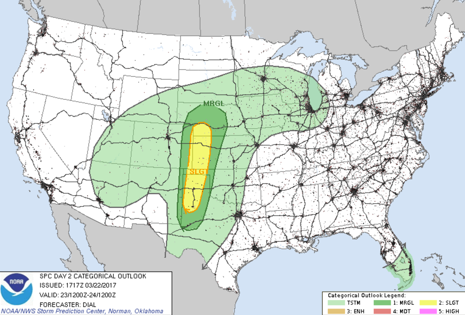
Severe storms possible
Some storms may become severe Thursday, but the greatest threat for severe storms should end up very far east along the Colorado / Kansas border, where a dryline will be in place. Any storms that do manage to break the cap out here will be capable of producing large hail and damaging wind. The areas of greatest concern all highlighted in yellow below:
Precipitation
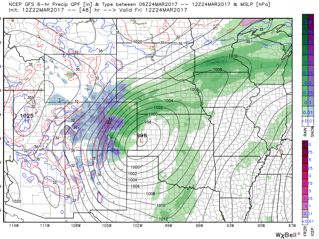
Again, there will be a sharp gradient from really good precipitation (whether rain or snow) to not much of anything. As of right now we think Denver does okay – somewhere in the 0.2 to 0.8" range, but a shift east will lower that number, while a shift west would increase that number.
The latest ensemble mean forecast from the EURO has about 0.8" at DIA, with 0.4" for Broomfield. This seems about right, and with pretty good consistency here will stick with it rather than jump on the GFS train out of town.
Snowfall forecast
Snowfall forecasts are never easy around here. This time of year, and coming off three weeks of summer? Even harder.
Here's what we know. Someone is likely to see a period of very heavy snow from this event, with the odds favoring the Palmer Divide – basically from Monument east. As you go down in elevation those odds will drop, and not only will be dealing with mixing, but also with the ability for the snowfall to overcome the very warm surface temperatures.
The best chance of snow will be from midnight Thursday through noon Friday, with some VERY heavy snow forecast early Friday morning along the Divide. That, in combination with the wind, will make travel very difficult between Denver and Colorado Springs for a time early Friday. Remember, even if you are just seeing rain where you live, conditions could be considerably different when you go up 500 or 1000 feet in elevation.
With that, here's our initial snowfall forecast. For now we don't expect a huge event in Denver (low end of 0 inches for Pete's sake!), but some accumulation is possible (if slushy) early Friday IF we can cool things enough. We'll keep a VERY high BI in place for now, as temperatures and warm surfaces a big concern going forward.
We'll continue to track all the latest over the next 24 hours hours or so... and offer an update to this forecast as needed on Thursday. I fully expect some curveballs from modeling tonight... so we'll see what impact that has on our initial snowfall forecast Thursday.