Hurricane Harvey: A Resource Guide

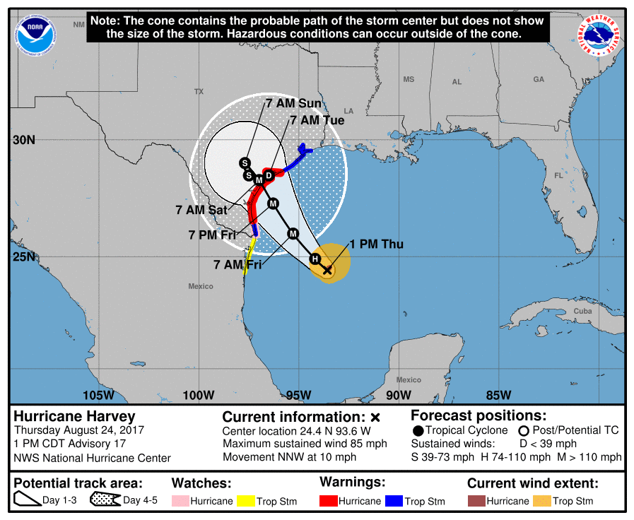
Hurricane Harvey threatens to make landfall in Texas as the first major hurricane to make landfall in the United States since hurricane Wilma in October of 2005.
Harvey, which has intensified rapidly over the last 24 hours, is now a category 1 hurricane with sustained winds of 85mph, and is expected to further intensify as it moves toward the Texas coast – potentially as a major hurricane – early Saturday.
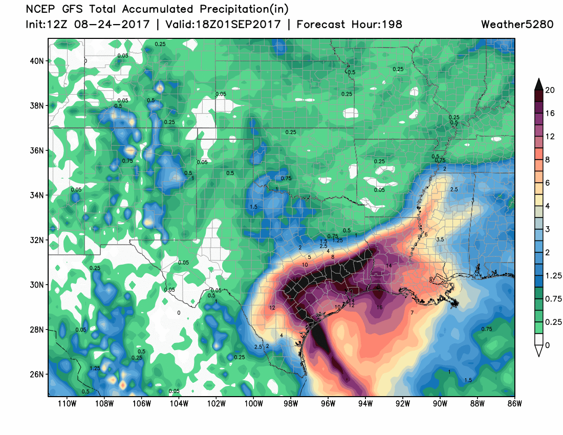
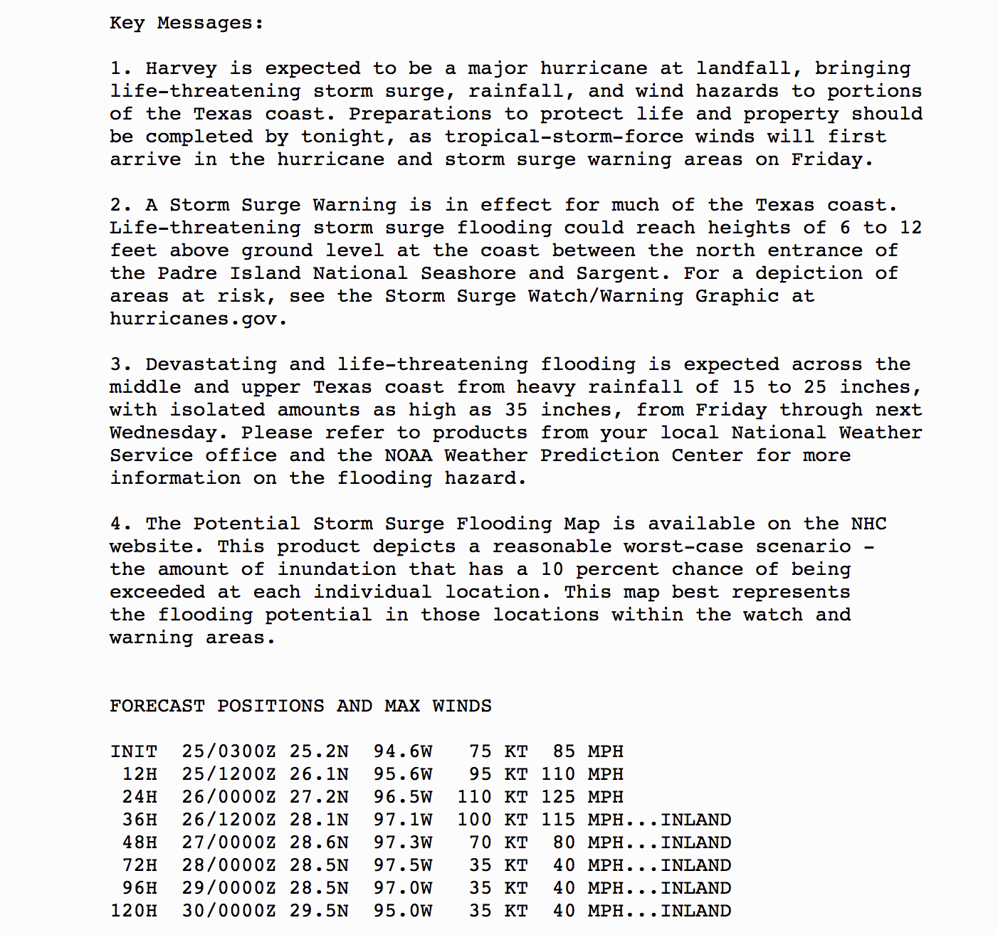
Harvey not only poses a threat with damaging wind, but is forecast to bring incredible rainfall to southern Texas over the next five days as it moves inland, stalls, then slowly moves east/northeast. Latest model guidances suggests upwards of 20" will be possible, with the potential to deliver catastrophic flooding to the region.
Here's the latest GFS forecast for precipitation over the next week:
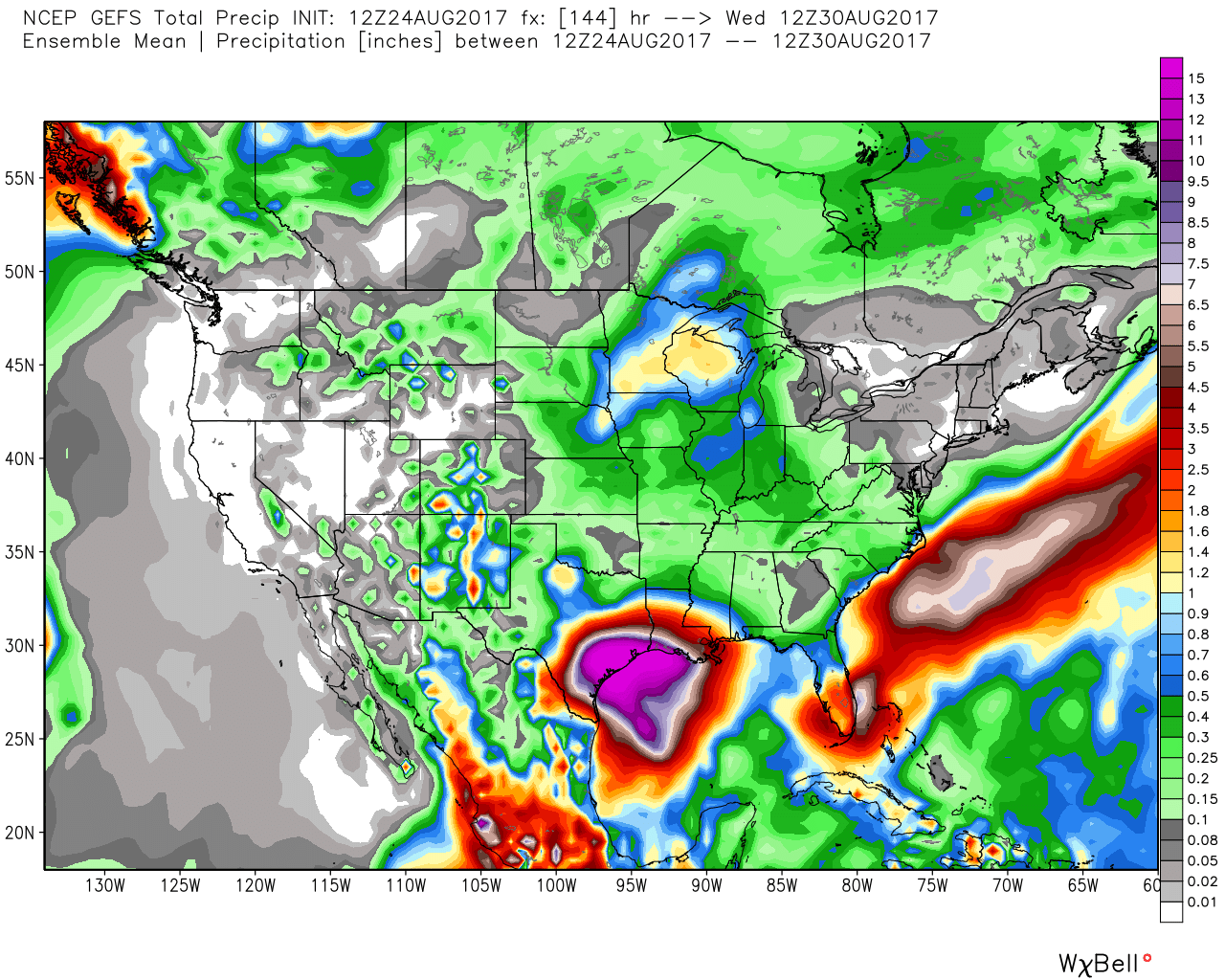
With the mean rainfall forecast from the GEFS 'off the charts':
If you live in the area, or know people that do, PLEASE make act now, and follow ALL evacuation orders that are in place or will be issued in the coming days.
While we likely won't cover all the latest updates with Harvey as we head toward the weekend, here is a list of resource that will be valuable for all in Harvey's path. There are many new tools available now as compared to 2005, it's certainly worth taking full advantage and staying safe ahead of this dangerous storm.
NOAA/TX Gov
- Hurricane Harvey resource page from the National Hurricane center. Links to latest forecasts, discussions, and maps.
- Storm Surge Warnings Storm surge warning map from the National Hurricane Center.
- Hurricane-force Wind Speed Probability Map For the next five days.
- Storm Surge Inundation Map
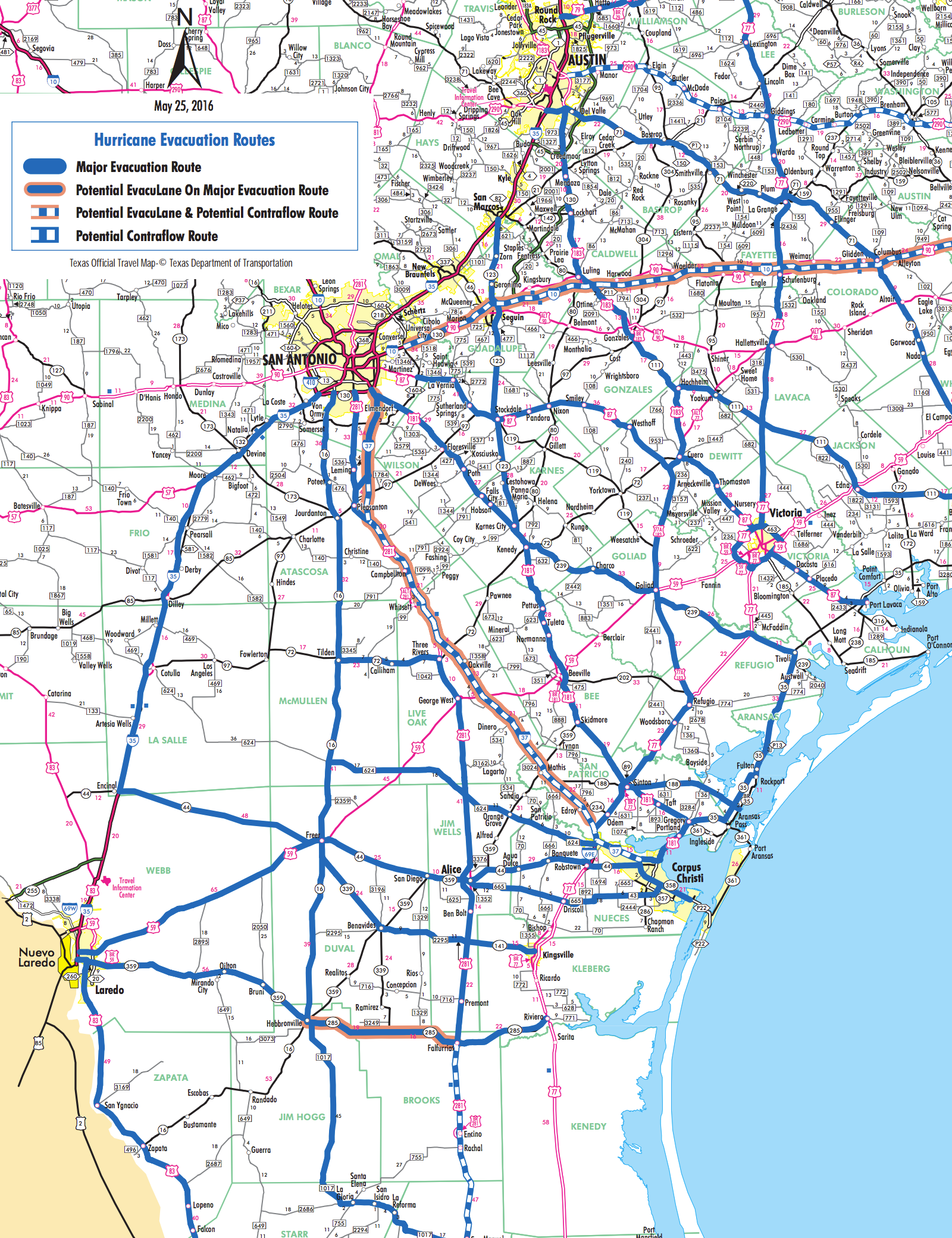
- Evacuation routes: Evacuation routes from the Texas Department of Transportation, like this one for Corpus Christi:
Harvey analysis
Go inside the storm with these great analysis sites:
- Capital Weather Gang: A long way from the cone, but a great resource to follow through the duration of the storm. Brian McNoldy is one of the best, and the CWG sets the standard for weather reporting, forecasting, and analysis.
- Space City Weather: Hype-free forecasts from Houston forecasters Matt Lanza and Eric Berger. Frequent updates here, with a no BS approach to what to expect from hurricane Harvey.
- TropicalTidbits: Levi Cohen (runs Tropical Tidbits) offers great video updates when storms are threatening. He's already posted several on Harvey, with detailed, easy-to-understand analysis of the storm.
Forecast Models / Satellite Imagery
Among the many innovations since the last major hurricane to hit the U.S., is the accessibility to weather model data at high resolution. Two sites worth geeking out with are:
- WeatherBell Analytics: Most model imagery here is behind a paywall, but wxbell continues to lead the way in offering the most comprehensive list of weather model data available on the web.
- TropicalTidbits: Levi Cohen continues to build out TropicalTidbits with loads of new features this year. For a free, easy to use interface to explore weather models (especially tropical variables), this is the site to use.
- COD Weather Among many great analysis tools on COD weather, are many GOES16 resources as well, including this experimental satellite Mid-Lvl WV Imagery for Meso Sector #1.
Twitter Follows
There are far too many great follows on Twitter when it comes to hurricane geeking and preparedness. Below are a few, with more in our Twitter list here.
- Matt Lanza: @mattlanza – Meteorologist in Houston, and co-author of Space City Weather.
- Eric Berger: @SpaceCityWx - Co-author of Space City Weather.
- Jeff Linder: @JeffLindner1 – Meteorologist with the Harris County Flood Control District.
- Michael Lowry: @MichaelRLowry – UCAR/FEMA task force lead. Great resource for latest on hurricane Harvey.
- Greg Postel: @GregPostel – Hurricane specialist at the Weather Channel.
- NHC Hurricane Hunters: @NOAA_HurrHunter –
Follow the NHC hurricane hunters as the fly into the eye of Harvey several times a day. - National Hurricane Center: @NWSNHC – Get the latest updates from the NHC via their official Twitter account.
- iCyclone: @iCyclone – Hurricane chaser taking you into the eye of the storm.