Arctic Blast on the Way, Some Snow Too

We're not seeing anything too unexpected since our update yesterday with regard to the cold and snow set to move in tonight and carry into Tuesday. It still looks like some bitter cold air is on the way as well as a good chance of snow across the greater Denver area, Front Range foothills, and Palmer Divide.
As expected, the EURO hasn't changed much, and, while other models have moved toward it, it remains one of the drier/least bullish models on the whole with this system. For precip the EURO control and mean has about 0.1 to 0.15" QPF across Denver (suggesting 1 - 4" of snow) while the GFS ranges from 0.1" at DIA to 0.35" over southwest Denver (suggesting upwards of 5" for areas south and west of I-70/I-25 in Denver. The GFS is not as bullish as it was yesterday, but still supports high-end totals for portions of the metro area (not everyone).
Bottomline, there are still big differences at a small scale between the models in how much moisture we'll actually see from this system. In general, would expect lower-end QPF values to win out, though a long duration light northerly upslope coupled with very cold temperatures could lead to some nice snow totals on Denver's south-side, Palmer Divide, and favored foothill locations. The snow will be very fluffy with these cold temperatures, so even if not much falls, it could pile up nicely in some spots.
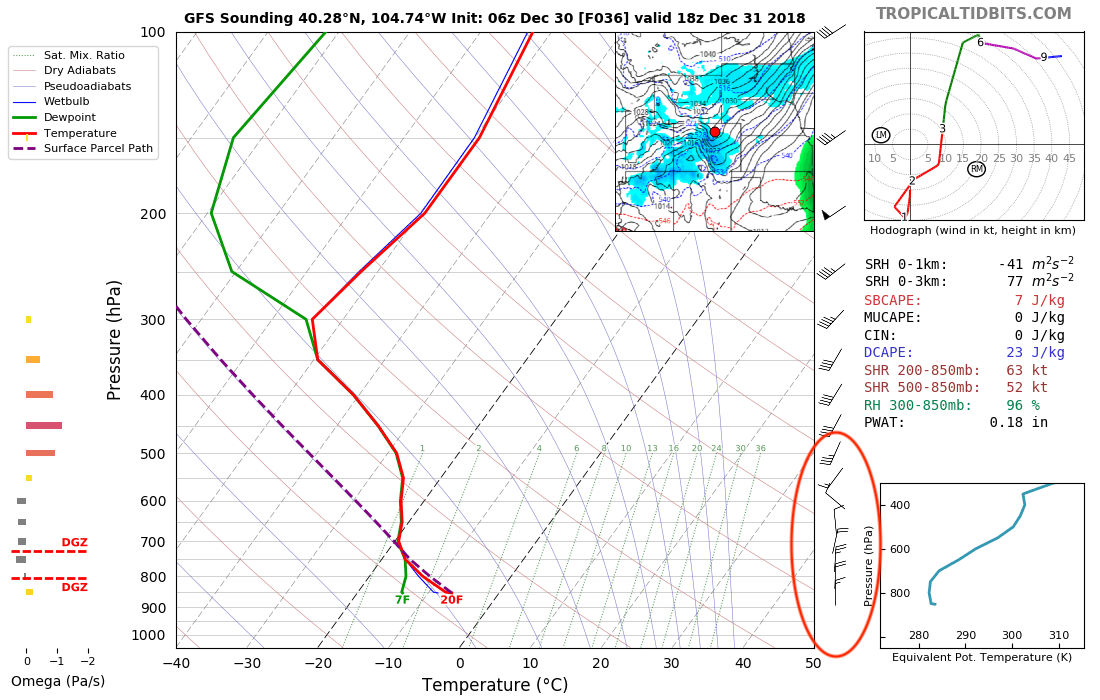
One thing models seem to agree on is that winds will be mainly out of the north, especially across northern Colorado. The GFS still has some slight northeasterly winds around Denver which could help promote a bit better upslope for the city if true. The northerly winds will mean downsloping for the northern urban corridor, so expecting snow totals to drop off in a hurry north of I-70, with most of the northern urban corridor in the 0 - 2" range. Here's the GFS sounding forecast for Monday morning -- the northerly winds quite evident:
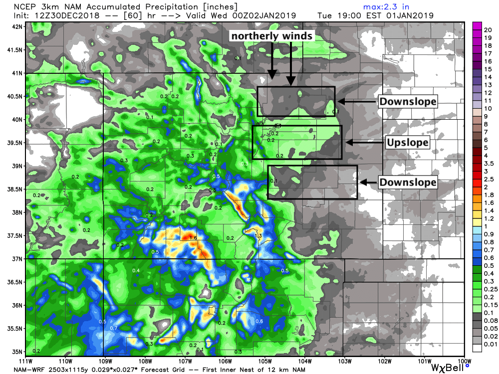
Northerly winds tend to favor the Palmer Divide and not much of anywhere else. With northerly winds we expect downsloping off the Cheyenne Ridge, upslope south of Denver against the Palmer, then downsloping off the Palmer south into Colorado Springs. The 3km NAM captures this well, placing the greatest precipitation right where we'd expect:
For our snowfall forecast we are counting on very high snowfall ratios, likely in the 20:1 to 30:1 range for much of this event. If true, this means even where models have just 0.15" of liquid, we could see upwards of 3" of (fluffy!) snow. We hope that where the models may be overdoing QPF we can make up for with these high ratios and come out with a good forecast across the area. See below:
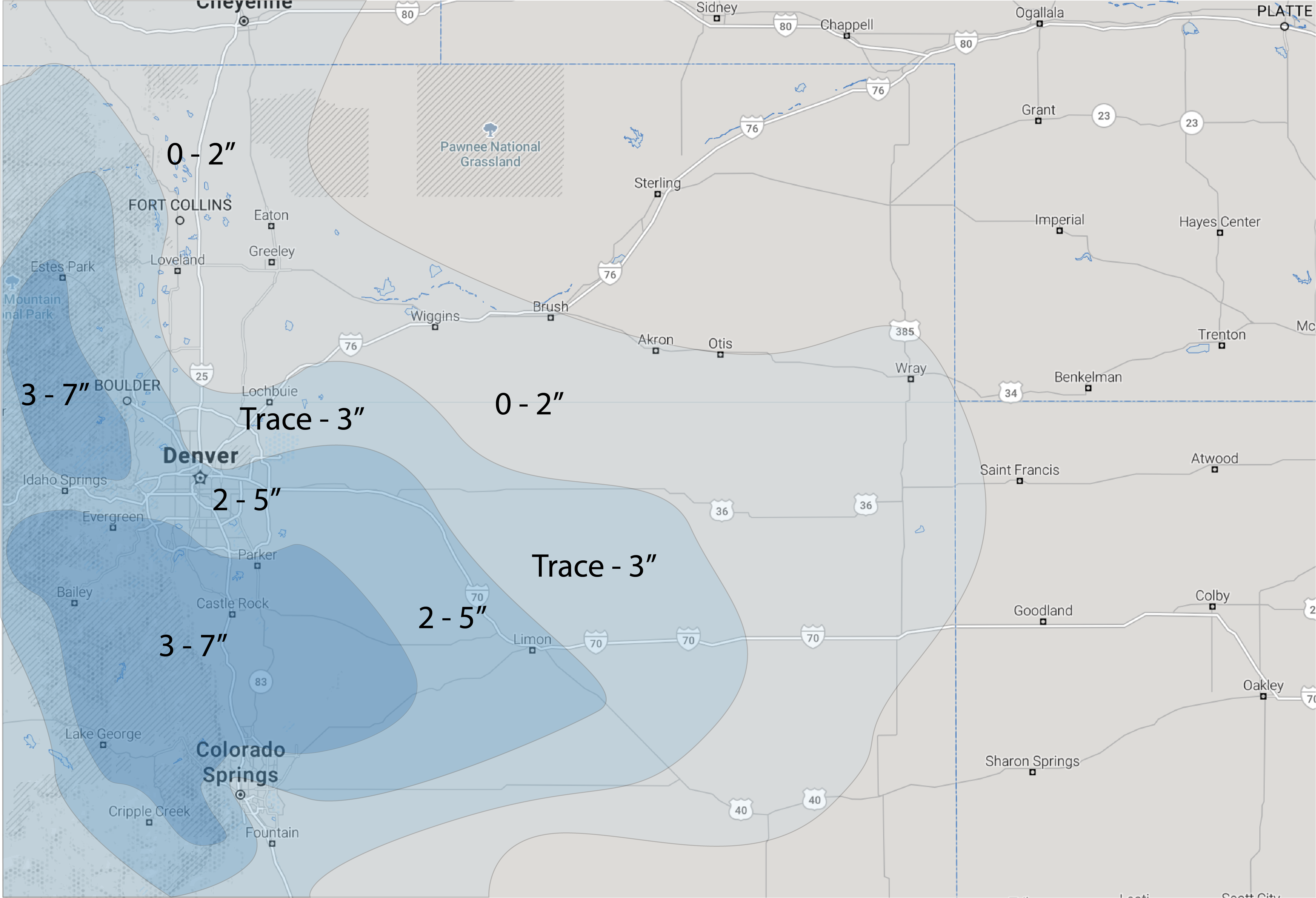
Totals for select areas should shake out as the following:
- Fort Collins: 0 - 2"
- Thornton: Trace - 3"
- Denver (downtown): 2 - 5"
- Denver (south): 2 - 5" (3 - 7" boom)
- Palmer Divide: 3 - 7" (4 - 9" boom)
- Colorado Springs: 1 - 4" (more north/west sides, less south/east sides)
While it might seem we're on the 'bullish' side of the forecasts... important to remember that our low-end totals for the above range from 0 - 3", so plenty of potential to see not-much-snow out of this system. If the EURO is right and QPF is overdone, we again will be relying on high snow ratios to carry our forecast to fruition.
On Weather5280 Insider: Snowfall Gambler Charts | Updated 12:30pm Sunday
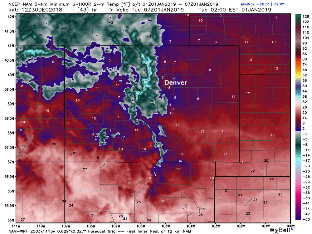
For many the COLD may be the bigger impact over the next couple of days. I don't think we can stress enough how cold it'll be Monday night if your plans take you out on the town to celebrate the New Year. Temperatures are likely to be in the single digits, with wind chills well below zero. Please plan accordingly!
tl;dr
Cold and snow are on the way. Most likely to arrive after dark tonight, with Denver's snow chance increasing as we head toward midnight and on into Monday.
Something to stress: don't expect to wake up Monday morning to the above totals. Much of the accumulating snow is expected to fall during the day Monday, and it may take into Monday night or Tuesday to see the final totals.
Daytime highs Monday are likely to be in the teens for Denver, falling to near zero degrees Monday night into Tuesday. Wind chills will be below zero.
Tuesday remains chilly with snow/flurries ending. MOS guidance has highs in the teens once more for Denver, before we warm into the 40s on Wednesday.
Travel will be tricky at times from late tonight through Tuesday morning. This is especially true across the Palmer Divide, though snow showers across all of eastern Colorado could lead to some pockets of winter driving conditions for everyone.
Stay safe, stay warm, and share your reports with us!
Happy New Year 🎉!