Monday PM Update: Wind and Snow on the Way

No big adjustments to the forecast issued yesterday. Changes are on the way later today in the form of strong winds, brief rain/mixing, snow, and blowing snow. Even in the scenarios we see lower end snowfall totals, the wind will be dramatic, and is likely to cause issues on the roadways tonight and early Tuesday.
We may see some shower activity as early as 4 or 5pm today, but timing of the main band of snow to kick things off looks to push through the Denver area after 8pm tonight. Expect gusty winds and heavy snow as it moves through.
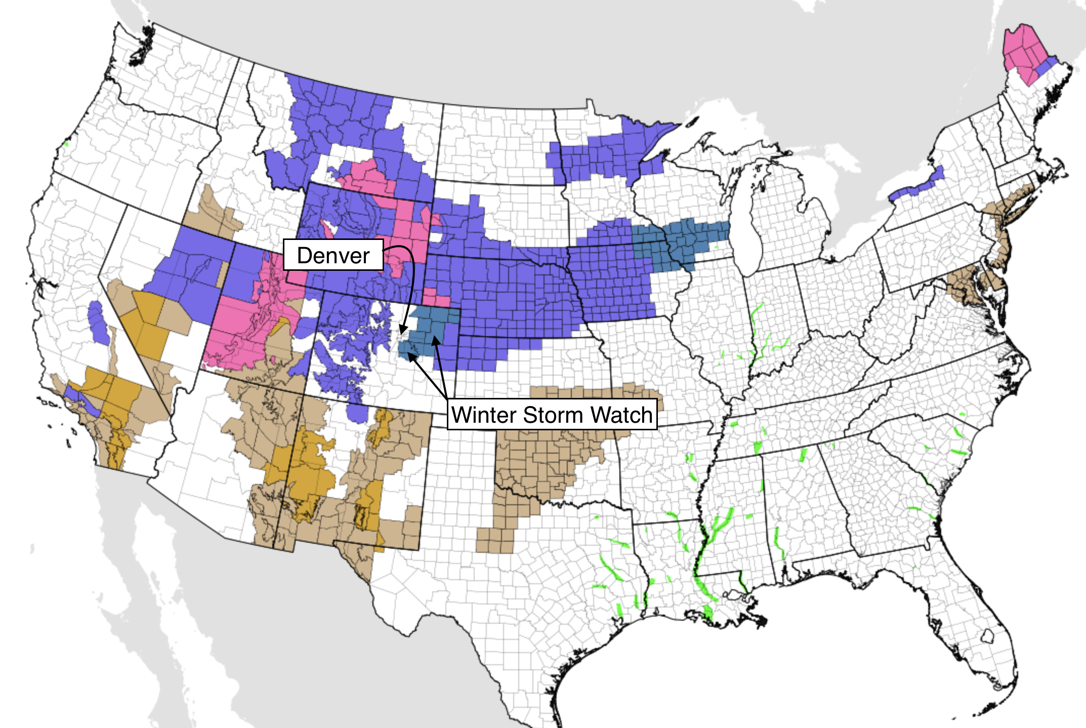
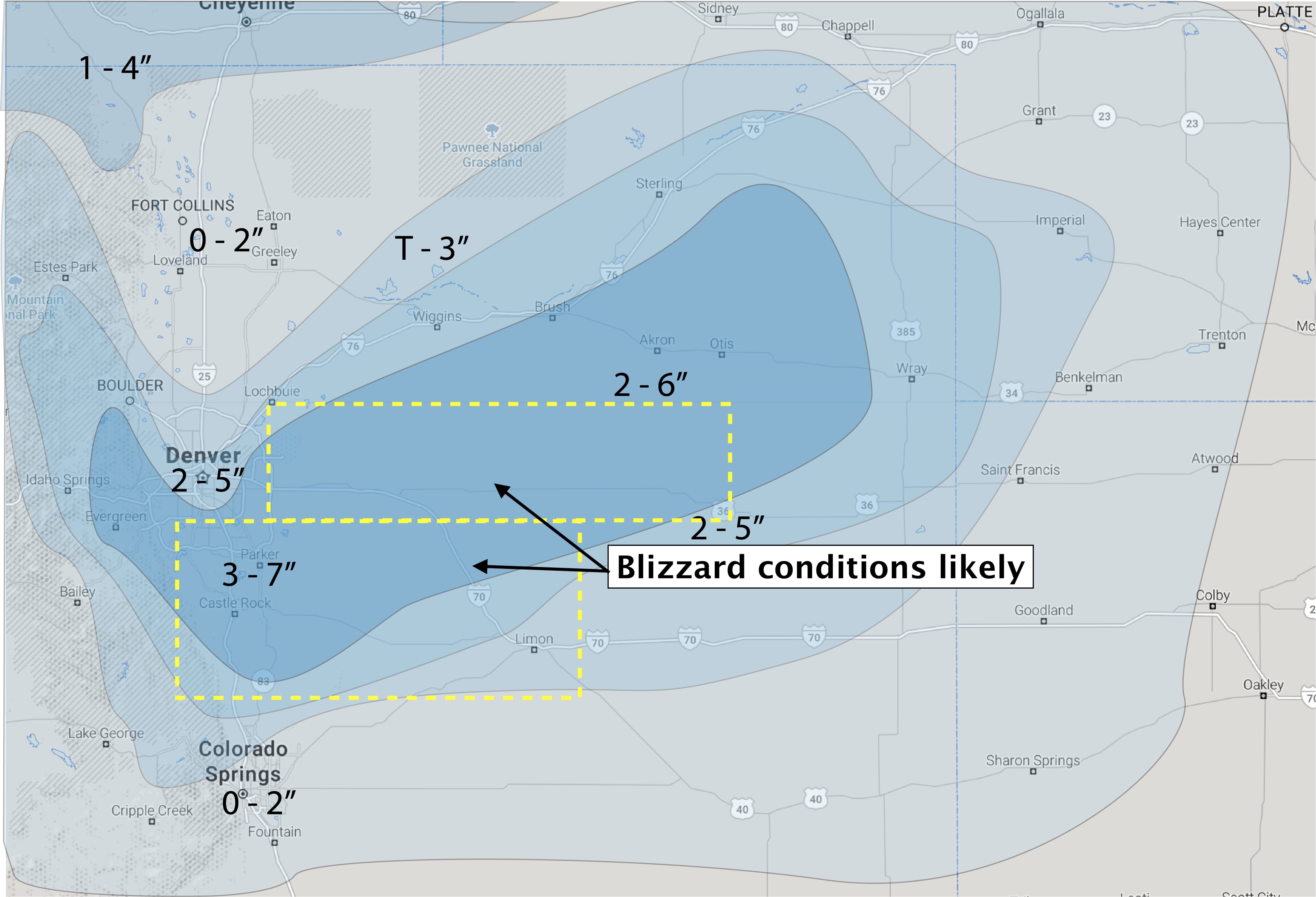
A Winter Storm Watch remains in effect for much of Northeast Colorado, but does not include Denver or points north. The worst conditions are expected south of Denver along the Palmer Divide, then points east/southeast of the city out across the Plains.
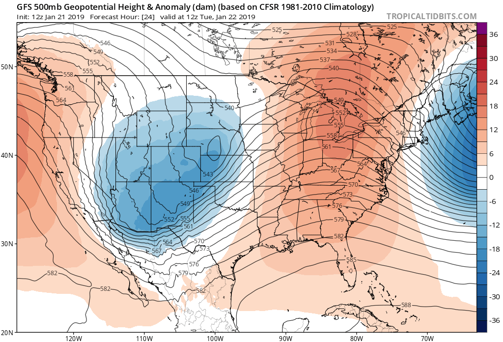
There are STILL discrepancies in the the data that will ultimately mean the difference of a boom or bust snowfall for the Denver area. We have, however, seen a handful of models come back toward the Euro's snowier solution since yesterday's post, which lends confidence to our forecast. The GFS remains much too fast and too far north to deliver any amount of significant snowfall to the region... and if correct, would be quite a bust to be sure.
Again, look at where it tracks the upper low Tuesday morning strengthening it well east (and too far north) of Colorado:
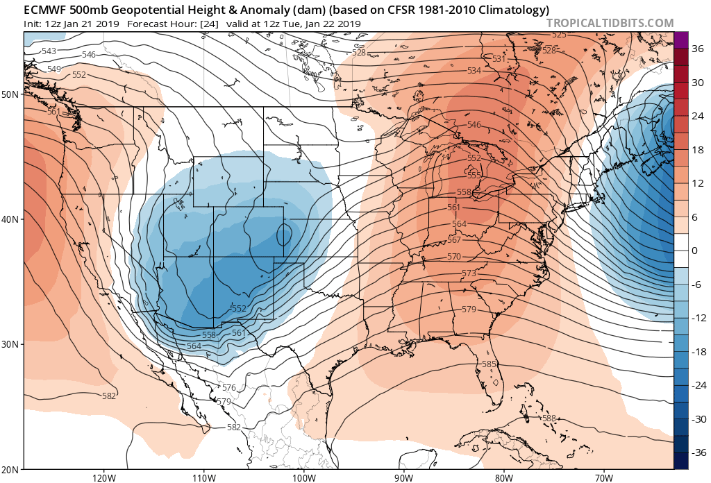
While the Euro has been consistently deeper and further southwest with the track of the low across Colorado tonight. Here it is valid the same time tomorrow morning:
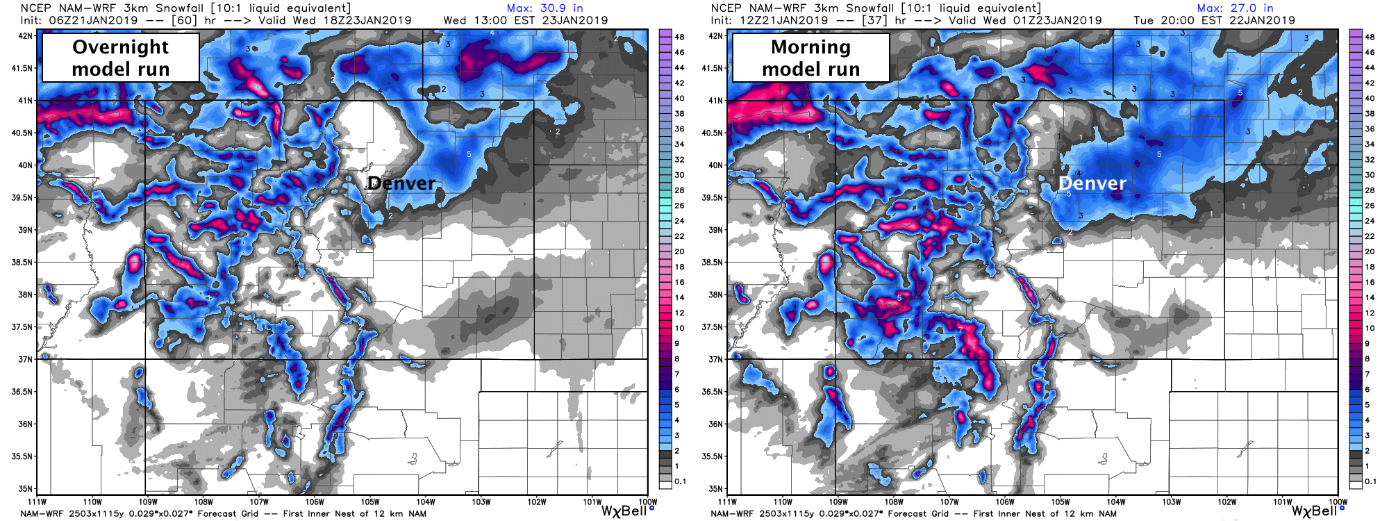
The NAM is again showing signs of life today as well. If we look at its 500mb forecast from overnight we see it was fast, north, and not really closing off with the low (bottom left). Compare that to its morning run (bottom right) and we see it coming in a little deeper, a little slower, and trying to close off again (see little green blob) as it intensifies across Eastern Colorado late tonight:
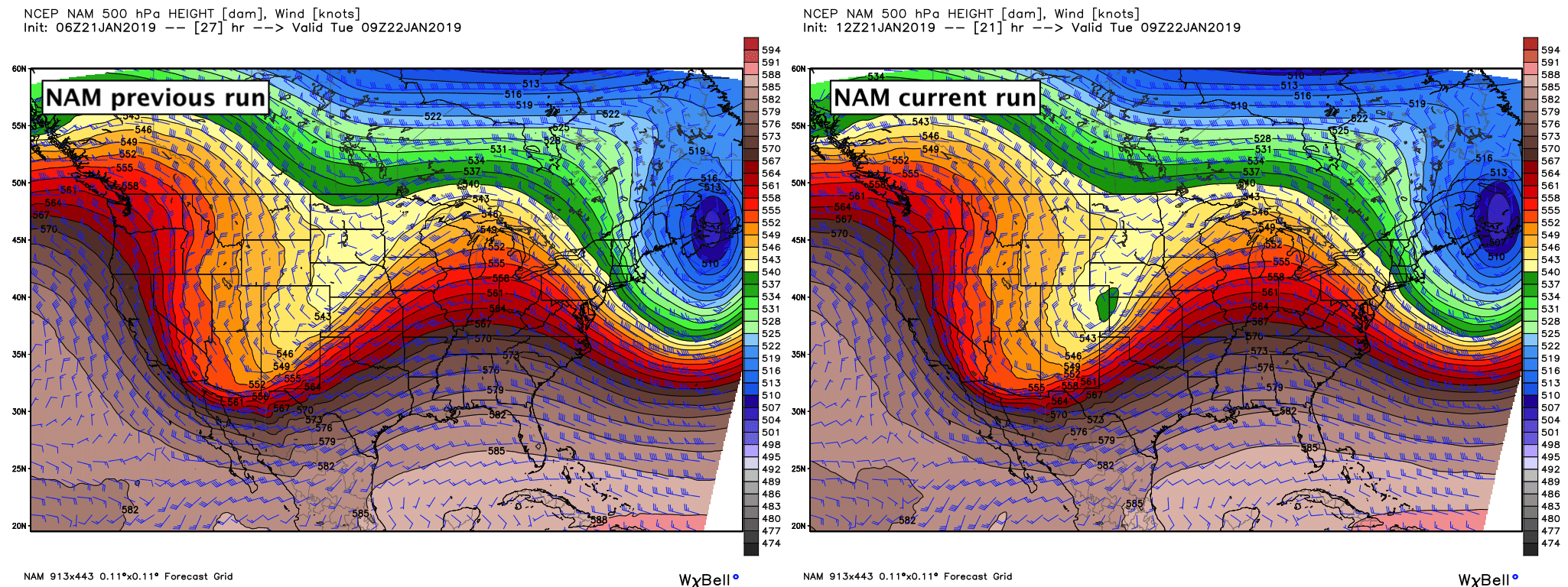
As you might expect, the snow output increased across Northeast Colorado between the two runs (below). You'll note, however, the northern urban corridor sees low-end totals in both scenarios, and, if correct west Denver may see less snow than say Aurora/Parker unless the slowing/deepening trend continues today:
The Euro is still the most bullish on snow. If it's correct, Denver, Boulder, Castle Rock, Aurora, Parker... etc, could all easily see 4 - 8" of snow, with locally higher amounts possible. If it's flat out wrong and the GFS somehow has a better grasp of things, we'll be talking about a lot of 0 - 2" totals for these same areas. How about that?
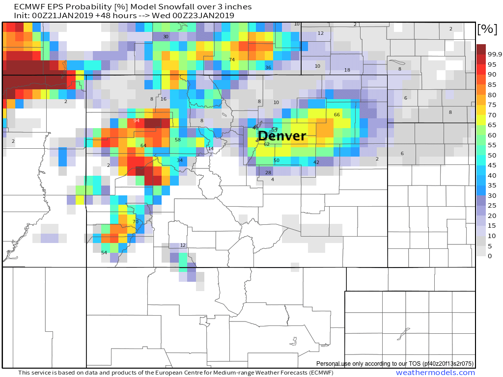
One reason not to jump too full-on the Euro snow output is its probabilities are still low-ish. Here's last night's run showing odds of seeing 3" or more of snow. 40 to 60% chances across the metro area, but greatest odds clearly south/east of Denver. Of note, this is based on 10:1 ratios, so perhaps odds are a bit better given cold air tonight:
Whew. The GFS is scary, but if it's right and we bust... then so be it. The Fv3 (new GFS) is closer to the NAM and Euro, so maybe it really has been improved? Time will tell.
In the end, we do think this could be a sleeper for some. And, even if we don't see huge totals, the WIND will make things dramatic at times tonight, and greatly reduce visibility across the region into Tuesday morning. Do not be surprised to see blizzard conditions across the Palmer Divide and Eastern Plains from late tonight into Tuesday morning. If you are traveling and commuting, plan accordingly.
With all of that said, we've adjusted numbers just a bit. We'll go 2 - 5" for Denver (more likely to see higher totals south and east than north and west) and bump the Palmer up to 3 - 7". Might we see some 8"+ totals out of this? Maybe. But we think the impacts remain the same, and with the wind it might be too hard to measure anyway!
Let us know how things shake out for you!