A Significant Storm Next Week for the Plains States, Details and Exact Track to Be Determined

Sunday evening update: The State of the Atmosphere: Sunday, March 10, 2019, "Will It Storm?" Edition
As we've been tracking for some time now on Weather5280 Insider, a potent March storm is set to move out of the Southwest United States this coming week, and intensify as it does so the leeward side of the Rockies. This looks increasingly like a strong storm, likely to deliver heavy snow, blizzard conditions, heavy rain, and severe weather to several states by the middle of the week.
But first, let's take a step back. Our winter outlook has long called for an active finish to the snow season (Sept - May) this year. February through April was our target period for Colorado to finally get on the storm train. So far, this has worked out pretty well.
Denver has recorded 32.1" of snow so far this season, officially, with the average to end March of 46.5". Our station has picked up 36.2" since September. In both cases most of that has come since mid January, with DIA picking up 23.9" over the last eight weeks, vs just 8.2" over the 4.5 months prior.
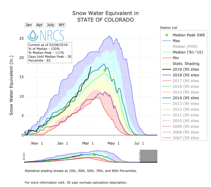
We've seen a similar turn in the mountains which have been dealing with record avalanche danger over the last week as statewide snowpack continues to rapidly climb. This season is the black line below. It's been at or just above the longterm median SWE until the last couple of weeks. Percent of median as of yesterday stood at 130% for the state. I also turned on 2018 (purple line) to show just how much better we are doing this year compared to last. Remarkable!
The storm next week is an important one. It's an important one to pay attention to if you live in Colorado, Kansas, or Nebraska, as wherever this storm ends up it's likely to be an impactful one. It's also an important one for our forecast. As recently as few weeks ago we wrote a post discussing the potential for this March that we haven't really seen in years. Additionally, a top analog year to ours since last summer has been 2003 –– the year we saw a truly great blizzard along the Front Range.
Now, before we look ahead to next week, know this: there is still a tremendous amount of uncertainty with regard to how things will eventually pan out next week. This is a look at some potential scenarios, and largely an opportunity for us to geek out a bit. The pragmatist in me knows all the ways this can go wrong (it usually does), the snow lover in me needs a big storm!
Next week
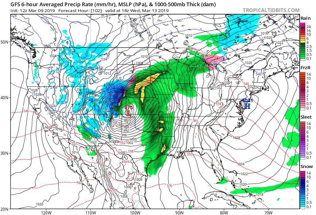
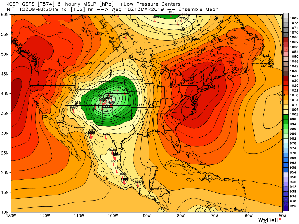
Models are in better agreement today with regard to the eventual track of this system. A strong upper level low that will move onshore Monday night across extreme Southern California/Baja, then track northeast through Arizona and New Mexico –– eventually moving into the Southeast Colorado Texas/Oklahoma Panhandles by Wednesday. Depending on which model and which run you look at... this just about as sweet-a-spot as you can get for a strong cutoff low this time of year to deliver ample moisture to northeast Colorado:
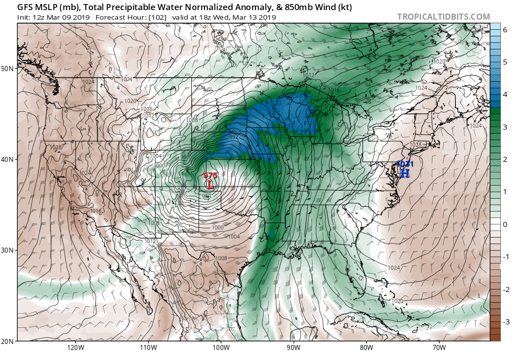
At the surface, we see most of the major global models now showing a strong area of low pressure developing on the lee side of the Rockies Tuesday night into Wednesday. In fact, some are showing near-record level low pressure across Southeast Colorado by early Wednesday. The latest GFS has a 975mb low over southwest Kansas Wednesday morning, with ripping winds across northeast Colorado –– focused on the Palmer Divide:
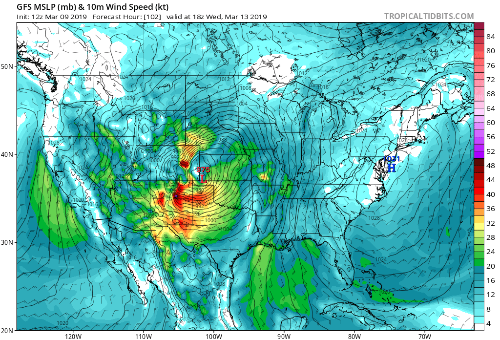
And when we say ripping winds, we mean gusts over 65 mph being likely. Should this track hold, expect a very wet system to move through during the middle of the week as it taps Gulf moisture and delivers anomalous precipitable water values to eastern Colorado:
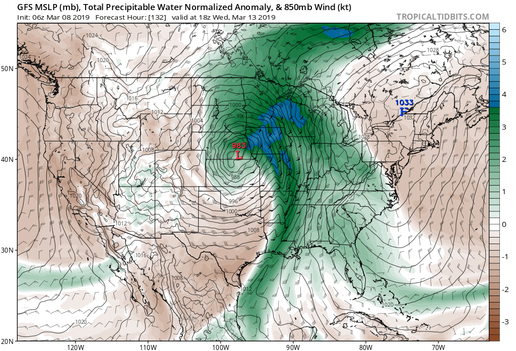
Now, the GFS is late to the party. The Euro has had this solution for several days, with the GFS just latching on today. The GFS has had a tendency to sink the low too far south, only to carve it northeast TOO LATE for big impacts across eastern Colorado. The Canadian still shows this. Here's a look at the same forecast hour as the map above, but from the GFS forecast yesterday morning. Dry, downsloping winds across the Front Range with hardly a storm to mention for our area:
Is this still a possibility? That would be a resounding YES. However, our inclination is to believe this is a less likely scenario at this point, especially as we see model ensembles come more and more into agreement with a more northerly/westerly storm track. Strong ridging to our east, coupled with a trailing low dropping out of the northwest should (in theory) work together to keep this low further north and west than the GFS/Canadian have been trying to do.
Ensemble support
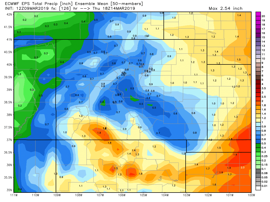
One important aspect to why we chose to write about this storm today is increasing model ensemble support for a significant event across eastern Colorado this week. The latest ensemble MEAN precipitation forecast form the Euro paints from 0.5 to 1.5" precipitation across eastern Colorado through Thursday morning. That'll come in the form of rain and snow:
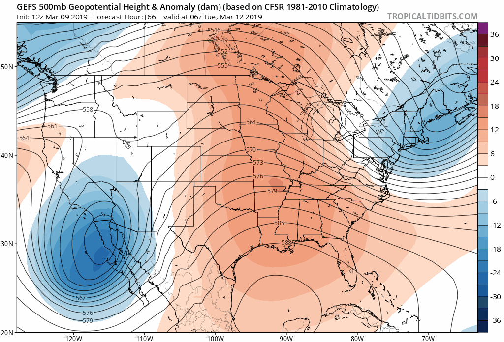
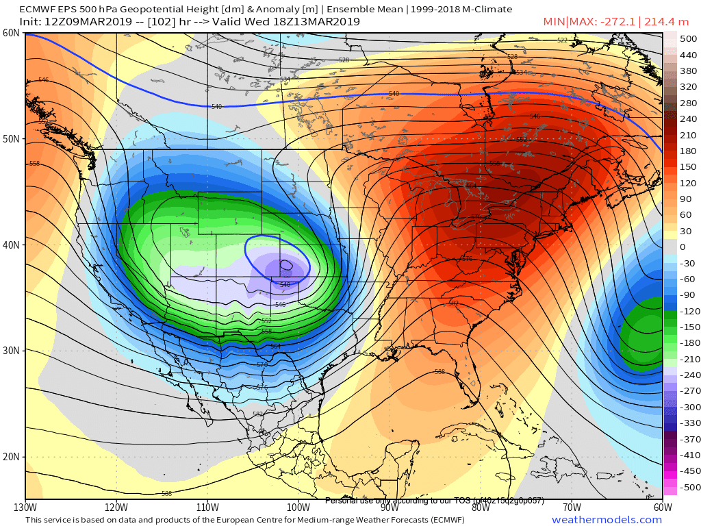
At 500mb we see an impressive negatively tilted trough swinging through "the sweet spot" Wednesday from the Euro ensemble mean:
And at the surface, great clustering from the various ensemble members for the placement and strength of the low Wednesday morning from the GEFS:
Considerations
If we see snow along the Front Range it won't likely be until late Tuesday or Wednesday. That's more than 3 days out with a high uncertainty track from a large cutoff low. What could go wrong? Everything.
So, before anyone calls bust... remember, this post isn't forecasting epic snow (yet!), but we want to lay out the potential as it looks like someone is going to get hit pretty hard next week. Whether that's Denver, the Palmer Divide, or counties well east of both remains to be seen. We started this site to write about interesting weather not sunny skies, so bare with us as we geek out a bit here.
For the urban corridor this feels like it'll go one of two ways: a direct hit with heavy snowfall and blizzard conditions (especially south and east of the city), or a near-miss... i.e. not much of anything along the I-25 urban corridor, but I-70 is closed at DIA with a blizzard in Limon (how many times have we seen this!). I'll be increasingly more surprised if this thing misses eastern Colorado completely to the east at the GFS/Canadian have been wont to do. This smells like an eastern plains blizzard for someone. Many think it takes a lot of snow to achieve a blizzard. However, with the very strong wind, it won't take much snow to cause some serious travel problems.
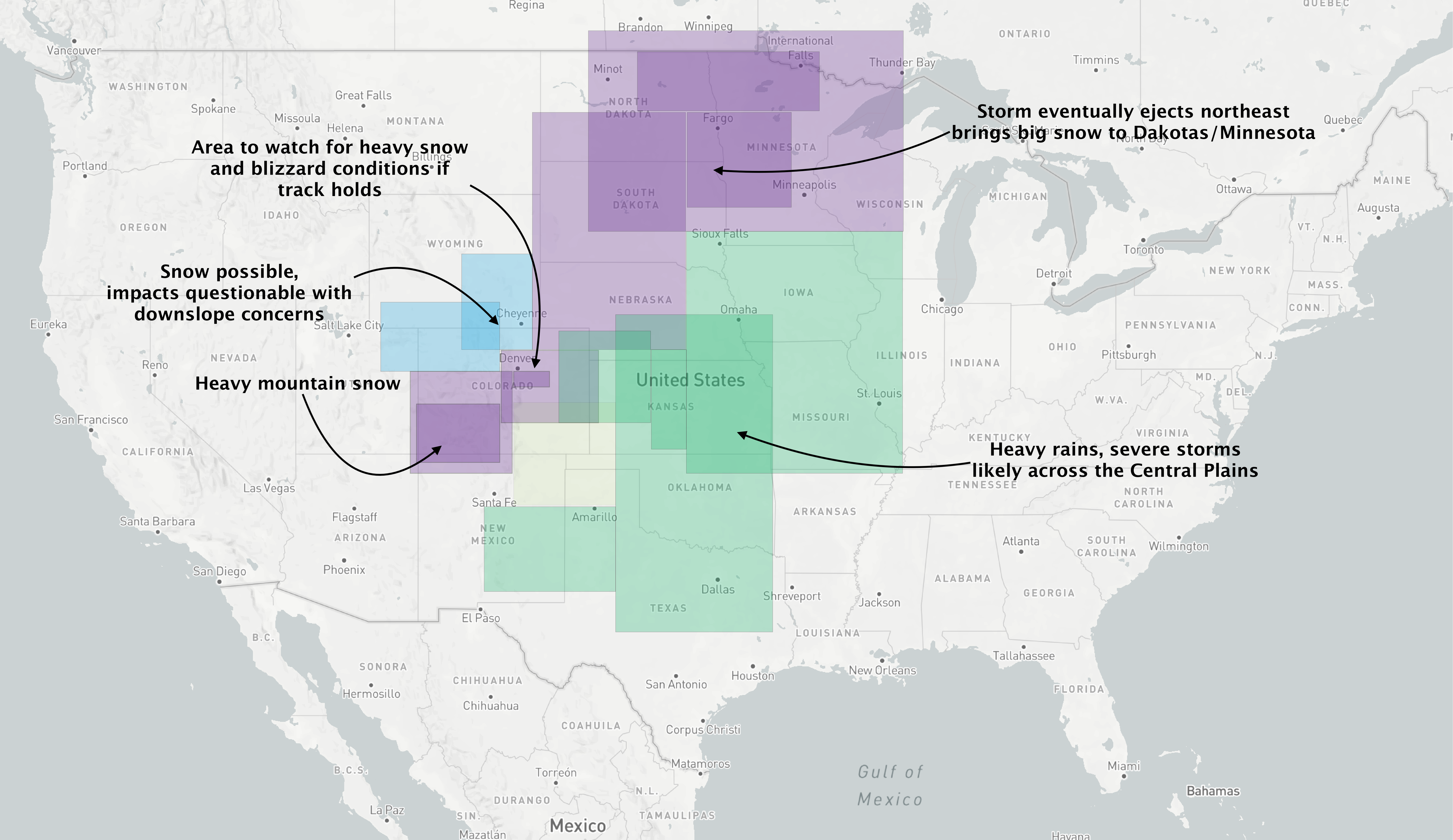
As we sit this afternoon, here's the most likely scenarios we see from this week's system. Darker purples indicate greater chance for heavier snow, darker greens for the heavier rainfall. Some hopefully helpful annotations to help illustrate...
Plenty more to follow... let's see how things look in another 24 hours or so. Stay tuned!.