
Throw Monsoon into the Polar Vortex and Bomb Cyclone Club

Matt Makens is a meteorologist on the Pinpoint Weather Team. He has nightly forecasts on Colorado's Own Channel 2.
In the ranks of misused and overused weather terms, we have Polar Vortex and Bomb Cyclone, and seemingly we need to add Monsoon to this group.
Let's discuss the monsoon in context of mostly Colorado's point of view.
What is the monsoon?
In our case, the North American Monsoon (NAM) is a seasonal weather pattern that develops a persistent wind flow. The wind flow is specific and brings tropical moisture into Mexico, Arizona, New Mexico, Utah, Colorado, and sometimes Texas.
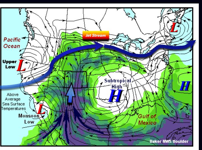
Using this image from the Boulder NWS office, note the high-pressure area over Texas (subtropical high) and the low-pressure area over/near the Baja (monsoon low). The corresponding wind flows with each feature pull in tropical moisture over the region (green colors represent tropical moisture):
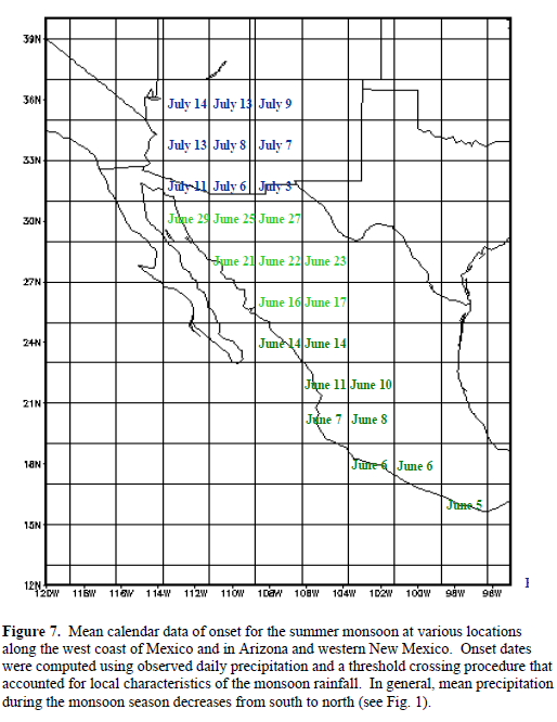
This seasonal wind flow observed from late June through September in which higher than average precipitation totals are measured within the region as listed above. A more exact schedule of when this starts shown here:
Within the monsoon's impact, there is a lot of research involving ocean conditions as well as the atmospheric characteristics as described above.
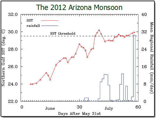
For one example, in some cases, but not all, the temperature of the northern Gulf of California needs to reach greater than 29°C for an increase in observed precipitation across Arizona. From the Desert Research Institute:
There is also research showing how climate change can possibly dry and delay the North American Monsoon a result of several impacted mechanisms.
No monsoon yet
Let's start with the atmospheric wind pattern, which has yet to establish itself in the monsoonal regime. Here is the average middle atmosphere pattern for the week, note the position of the high is too far west:
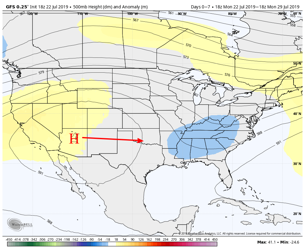
So, is this year's monsoon delayed? It's possible; however, the position of the high doesn't change too much over the coming weeks via the same modeling. With this western position, there's no way to develop the monsoon low, either.
Bottom line, we haven't established the wind flow necessary to bring in a steady supply of tropical moisture. And, that doesn't appear to change in the coming week(s).
Further evidence of the absent monsoon is in the dismally dry condition across the western US. Here is the observed rainfall for July to date:
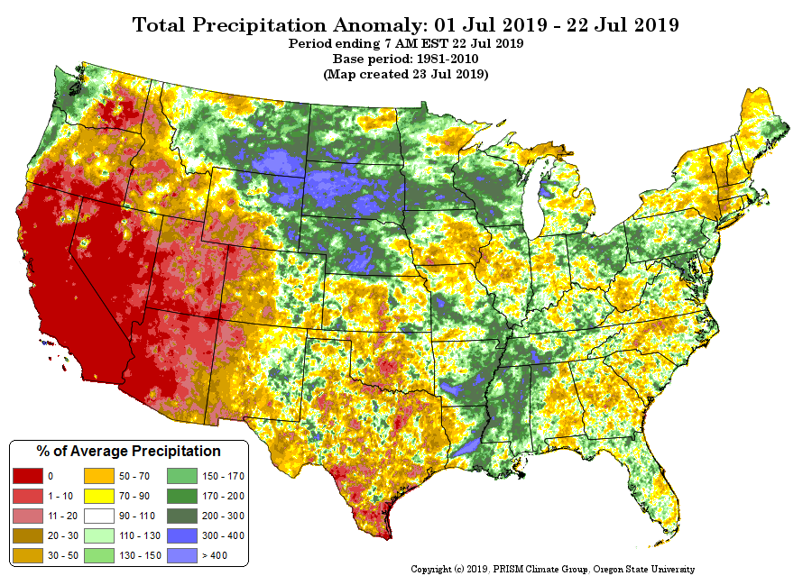
Note how dry Arizona and New Mexico are despite the average start dates for the monsoon as shown above in the second image of this post; WAY behind schedule.
I can go on by showing you that the ocean temperatures of the northern Gulf of California aren't warm enough yet (again, by some research definitions to be 29°C and warmer) but I think you get the point that the atmosphere hasn't established the monsoon.
Denver, Fort Collins, Colorado Springs, etc. have had wet days recently and those events have erroneously been called monsoonal thunderstorms.
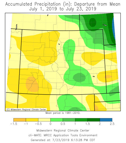
Here is Colorado's rainfall deviation to date for July showing most of Colorado drier than average:
I think the Colorado Climate Center has the best summation of what the monsoon is, "Over the southwestern United States, the NAM typically ramps up in July and persists through August. While you might observe some occasional wet days before it arrives, or some drier days after it's arrived, a fairly persistent, large-scale pattern will emerge."
What Colorado has seen is some wet days. For many it's been more dry than wet, however. We have yet to observe the "fairly persistent, large-scale pattern" that is the monsoon.
Arizona just recently started to see a bit of a push of moisture, so there's hope for a late-onset in Colorado rather than no onset, but we shall see.
Does the monsoon impact us?
Yes.
Via the Princeton research briefer linked above, “Because much of the NAM region critically depends on summertime monsoonal rainfall, the results of [this research] underscore the necessity of planning future water resource management around the likelihood of reduced monsoonal rains,” said Benjamin Lintner, an associate professor of environmental sciences at Rutgers University, who was not involved in this study.
This image will help visualize the areas of greatest rainfall benefit and when:
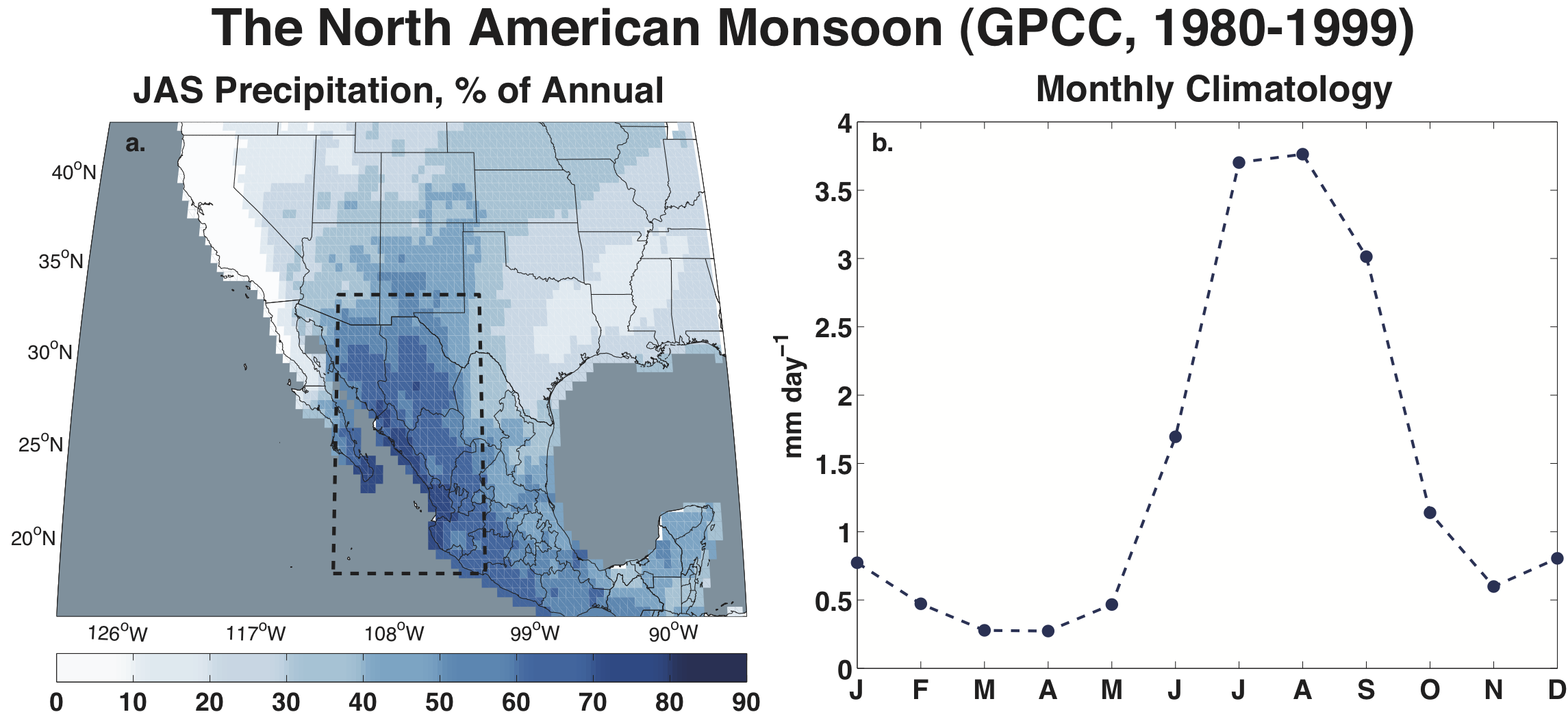
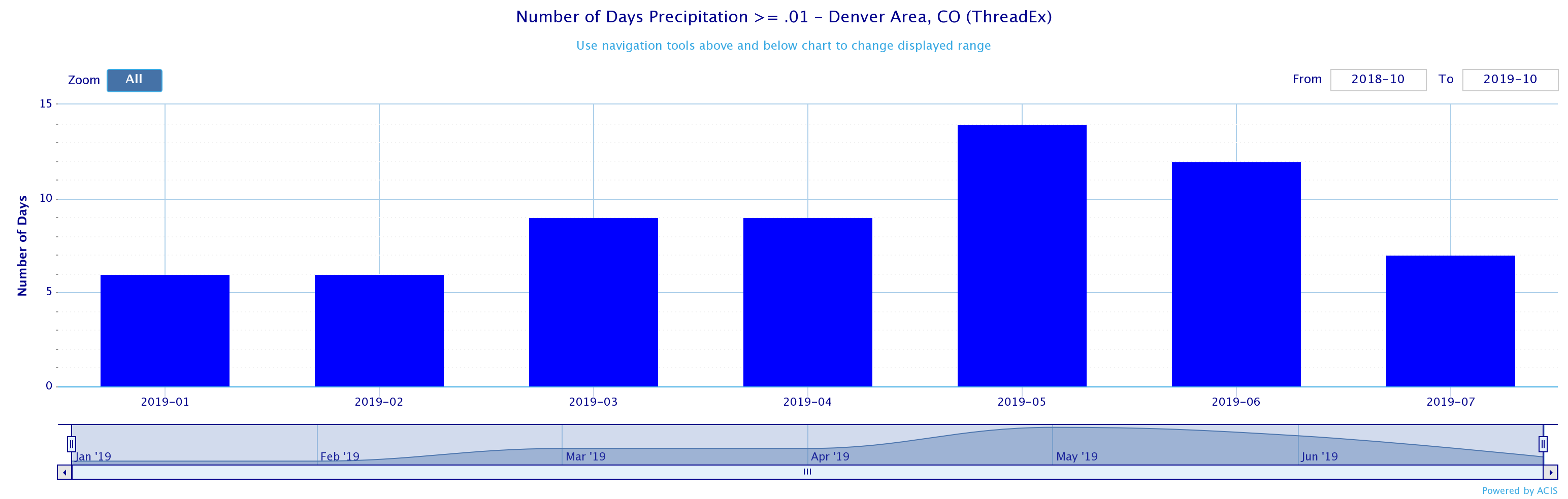
Colorado does benefit from the monsoon as you can see in the map above, plus here's Denver's annual precipitation climatology via NWS-Boulder. The annotation showing when the monsoon develops, on average:
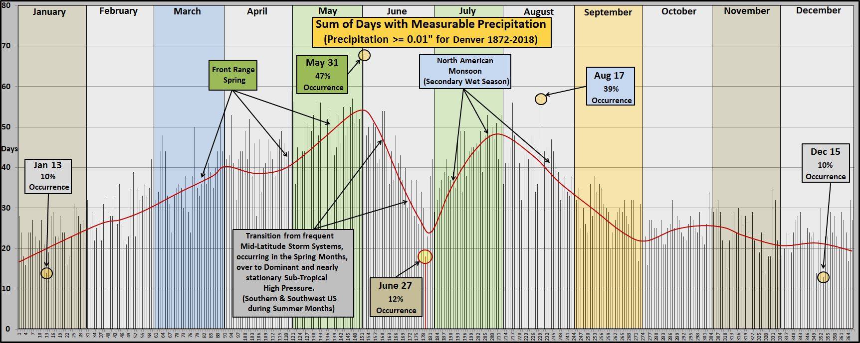
We measured the first peak in May, as per the normal. July has yet to show a secondary peak due to the absence of the monsoon.
For the rest of July the European model doesn't offer much of a wet signal for the state nor region:
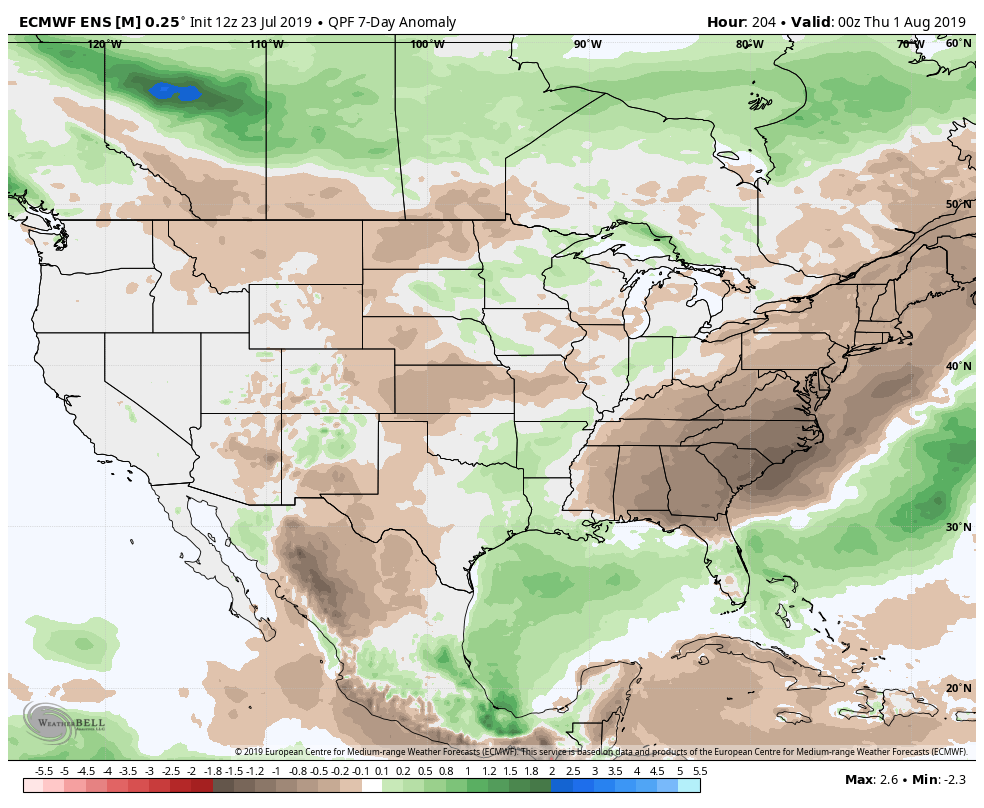
The complicating news for monsoon watchers, modeling this time of the year struggles with rainfall predictions in the monsoon region.
The NAM is generally most under-predicted by regional models in terms of precipitation. So there is that to consider, although observations to date confirm the models' forecasts for overall dryness.
Without the very basics in place as described in this post, any rain we do get isn't part of the monsoon.