
A heavy snow event is not off the table, measuring the probabilities as winter in summer takes aim at Colorado

With each model run we keep expecting them to backoff their snowfall output. There's plenty that's eyebrow raising about what models are currently forecasting for Colorado in this upcoming week. Looking at 500mb temperatures, ground temperatures, speed and strength of the trough... A LOT would have to line up for the type of extreme weather event to take place this week that many operational weather models continue to predict. Currently much of the modeled snowfall maps are at odds with every other factor at play.
Still, odds are increasing that portions of the northern urban corridor will see their first accumulating snow of the season this week, meaning more than 0.1" of snow measured. Let's take a look at the latest probabilities, and answer the one question we've been asked a lot: is this even possible?
Historical precedent?
Looking back at past September snow events for the Denver area the one currently showing up in the modeling would be in rare company indeed.
There are only two snowstorms on record where measurable snow fell on or before September 8th – that's Denver's earliest snow on record which came on September 3rd, 1961 when 4.2" of snow was recorded for the city, and 1962 when 0.7" was measured on the 8th. That's it.
Probably not surprising given the fact it's early September, but both snow events followed very warm weather. There's been a lot of chatter about if what's being forecast in the models is even possible – and, while simply taking a 10:1 snowfall forecast will be overdone, it IS possible to accumulate snow even coming off recent heat. The snow must fall fast and heavy, and timing it with night vs day is also key.
In 1961 the temperature two days before 4.2" of snow accumulated in the city was 85°F, and in 1962 the temperature two days prior was 89°F. This year we'll see record or near-record heat two days prior, with temperatures expected to near 100-degrees on Sunday. With that, this event would have more to overcome, but 85 and 89 degrees are exactly snow-friendly temperatures either.
Contest: Predict Denver's first measurable snowfall and win a Weather5280 shirt!
As for snow in September? For a lot of folks that likely seems at odds with your memory. If you've moved here in the last 20 years you have never see an accumulating snow in September. Still, the longterm average for the month is 1.0" for Denver, with more than a handful of years where the city has measured snow in September (usually during the latter half). The snowiest September on record came in 1971, when Denver saw 17.2" of snow for the month!
So yes, it is possible, but not common, and increasingly less common.
What are the odds?
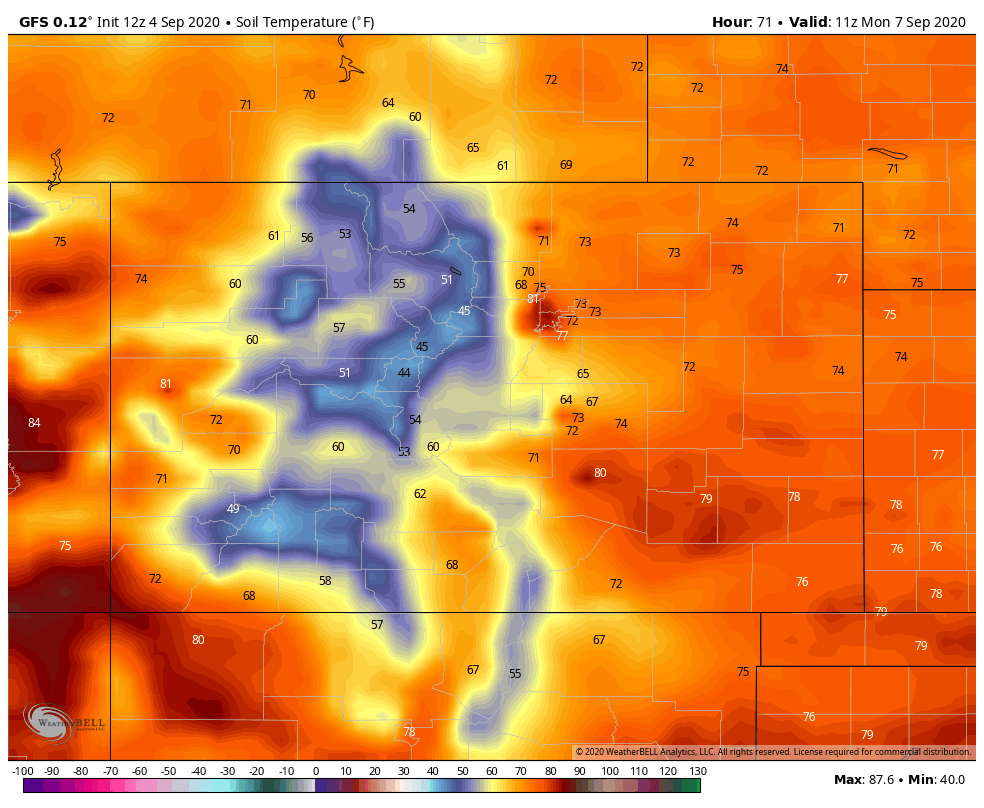
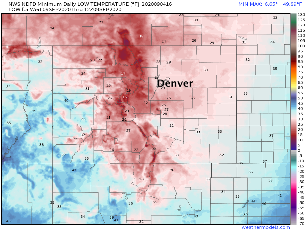
For accumulation high sun angle, surface air temperatures, and extremely warm temperatures will be factors working against accumulation along the urban corridor. IF we are to see accumulating snow this week, most of that will unfortunately be on trees and other vegetation. Soil temperatures by Sunday afternoon are forecast to be in the upper 70s and 80s across Eastern Colorado (see map below), which are temperatures even heavy snow will have a hard time overcoming for any amount of time:
It's the trees we'll have to worry about. Assuming for a moment some of the snowier solutions are accurate, and then accounting for a great deal of melting... 3 - 5" for parts of the metro area wouldn't be out of the question. This would be awful news for our trees, and would lead to potentially catastrophic damage and power outages across the region if it were to come to fruition.
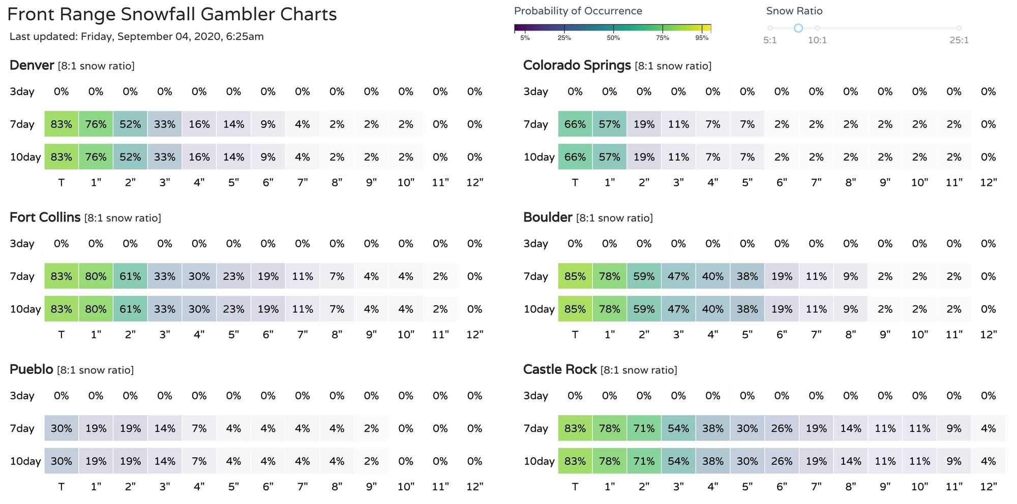
Our latest snowfall gambler charts show about a 50% chance Denver sees 2" of snow or more this week. For Boulder and Castle Rock those odds climb to 60 and 70%. You'll notice some long trailing higher probabilities (low they may be) which indicates plenty of uncertainty in the data, and that some solutions want to bring considerably more snow to the region. Despite days and days of crazy looking snowfall maps, we think the trend this weekend will be to lower those totals, and that the following probabilities are safer guidance at this time:
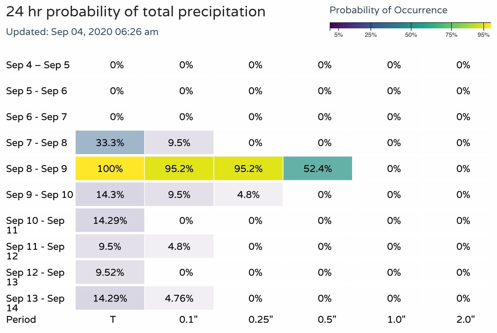
Not all the moisture we see with this system will fall in the form of snow. We'll see rain, showers, and thunderstorms as well as this front plows through the region. Here are the latest precipitation probabilities for Denver:
Temperatures, briefly
We talked quite about the the record heat and dramatic temperature drop to follow in yesterday's update, you can find it here. Data since then has only trended colder for both Tuesday and Wednesday mornings. As we mentioned above, we do wonder if we see temperature forecasts moderate a bit as we head into the weekend... so something to watch for.
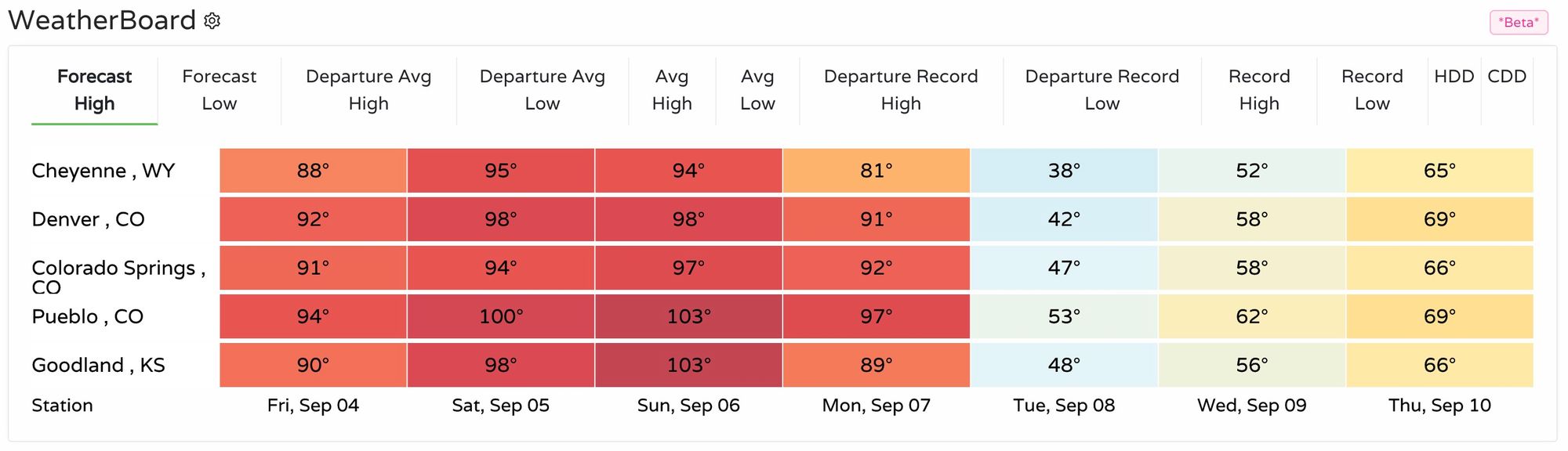
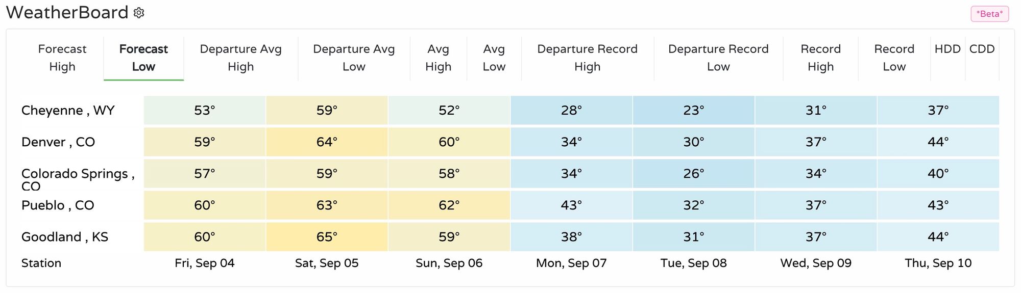
Even if they do, it will be cold. And it looks increasingly likely that many of us will see temperatures below freezing this week. If not Tuesday morning, Wednesday morning. Here are the current low temperatures forecast for the state.
Tuesday's lows:
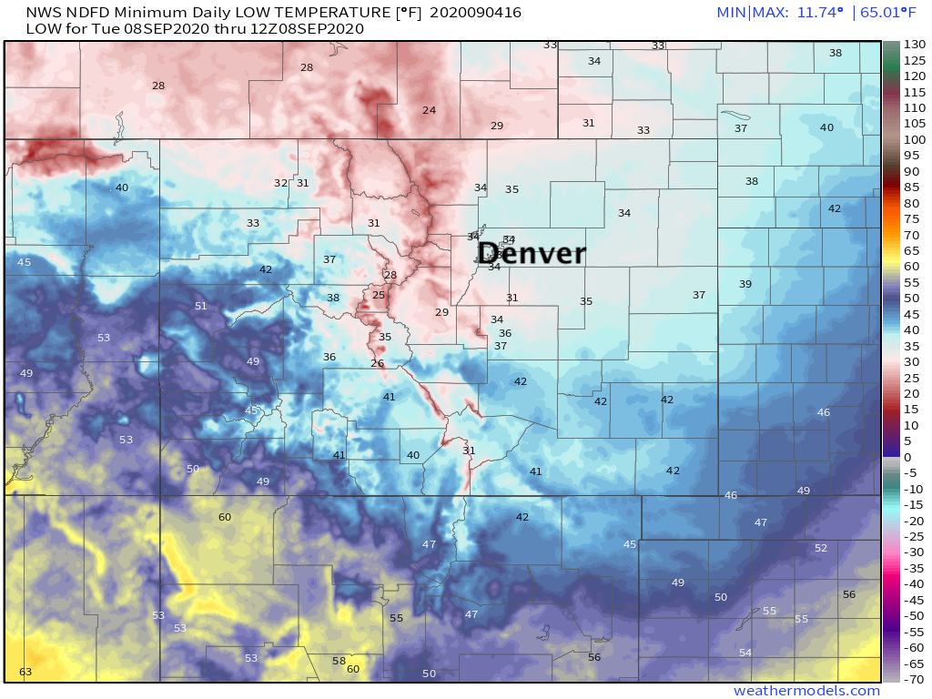
Wednesday's lows:
Snow or no snow, that's COLD for early/mid September!
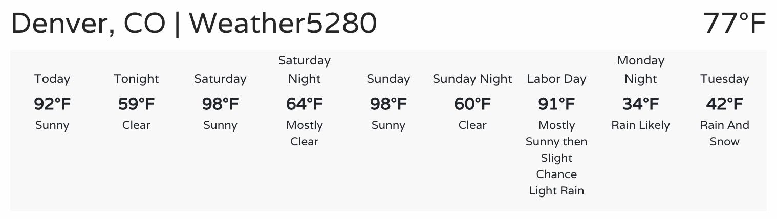
Regionally here's a look at current forecast highs/lows for the next week. You are reading this correctly – a high of 98°F for Denver on Sunday, and a low of 30°F on Tuesday!
As for timing... hot and dry will be the word through at least Sunday, with temperatures again expected to break the 90-degree mark on Monday before the changes arrive. We'll see an increased chance of showers and storms Monday, with rain and possibly snow likely by Monday night. Tuesdasy will be raw, with highs in the 30s and 40s and rain and snow continuing.
Still plenty of time to see how things will eventually evolve. For now plan on getting out and enjoying a hot summer weekend, and keep an eye on the forecast for next week!