Denver claims biggest snow of the season as heavy snow converges on city

A good old fashioned snow day! Or rather, in any other year what would have been a snow day, but this year school district after school district decided that should no longer be a thing. Just in case the last year hasn't been challenging enough, let's be sure to not give anyone a break – ever!
All the right ingredients came together for this one, with the focus of the heavy snow ending up right over Denver (hello GFS, we see you).
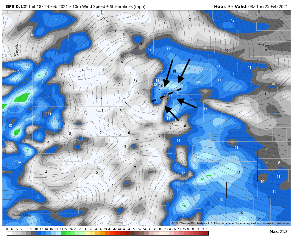
One of the main mechanisms that pushed the heaviest snow over Denver was an area of convergence that setup over the city. This was actually pretty well-forecast by the GFS, and helps explain why it focused the heaviest snowfall over the city proper vs a more classic upslope event where the heaviest snow would end up west and south of the city across the surrounding higher terrain.
In the image below you can see those converging winds over the city last night. Winds out of the northeast and winds out of the southeast providing a focused convergence zone over the metro area. This "Denver cyclone" helped enhance moisture convergence over the city, and meant favorable upslope flow for some – but not for others. Those on the southeast side of the Palmer benefited from that upslope flow, but Castle Rock, and to a certain extent the foothills west of Denver, were shorted in many cases.
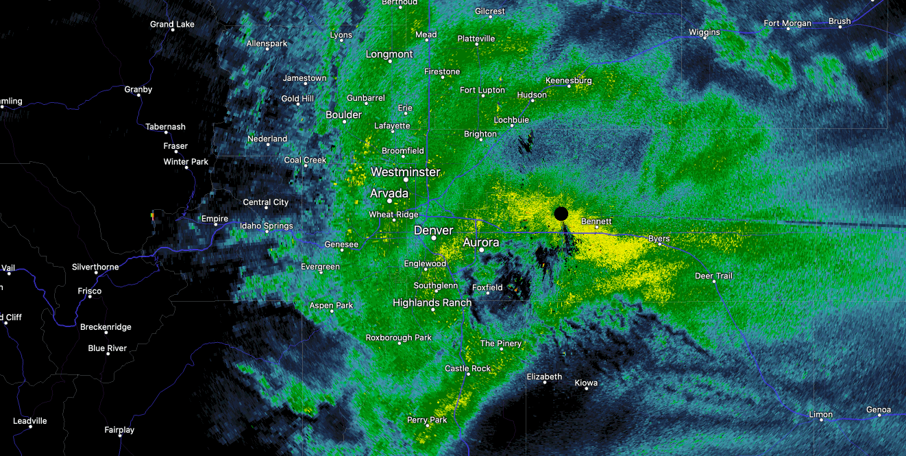
The result of this convergence was a band of very heavy snow, first over the northern metro areas late Wednesday afternoon, but then eventually focused over the Denver metro area for the night.
In a great summary from the National Weather Service in Boulder, this wasn't the only mechanism in play – many ingredients came together last night for this heavy snow event, including very likely some additional enhancement from the jet overhead:
Wow. What a storm for Denver. Wouldn't be surprised to see a couple spots wake up to a foot of snow given the impressive radar returns and persistent banding. Many others across northeast Colorado might be asking what's all the fuss, as heavy snow focused squarely over the Denver metro area last night, and even continued into the early morning hours. This storm seemed to be fueled by by modest low level convergence and instability along a Denver Convergence Vorticity Zone (DCVZ) last evening. However, even as this convergence has weakened/broken down overnight, the band refused to wane. There was also some mid level frontogenesis, and possibly some upper level divergence early on associated with the upper level jet. Those features are weakening as well. Eventually we'll see this storm loosen its grip on the forecast area, as we have frontolysis moving in even with the sheared weak trough axis still to our west. Weak QG lift will also be replaced by large scale downward forcing through the afternoon.
The European model clearly did a very poor job resolving this setup. The GFS was closer, but not perfect either. The HRRR had the right idea, but wrong placement. Other short-term, high-resolution models were similar to the HRRR, with the right idea but wrong placement of the heaviest snow. Clearly our forecast came up short for the city of Denver and immediate suburbs, but we're always happy for a boom snowfall, even if it's harder to enjoy with a forecast at risk!
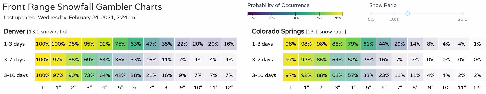
Snowfall totals
It came increasingly clear yesterday that this storm had some potential to get interesting in a hurry. Happily we upped our snowfall totals forecast yesterday morning, and outlined that many models had indeed latched onto the idea of the heavier snow – save for the Euro.
Our gamblers certainly hinted at a high-end event as well, with the high-end probabilities showing nearly 50% odds of breaking 7" in Denver. The 10 - 12" totals were clearly a low probability, but not an impossibility. Here were the early afternoon runs of the gamblers for Denver and Colorado Springs, we could have leaned a little heavier on these it seems:
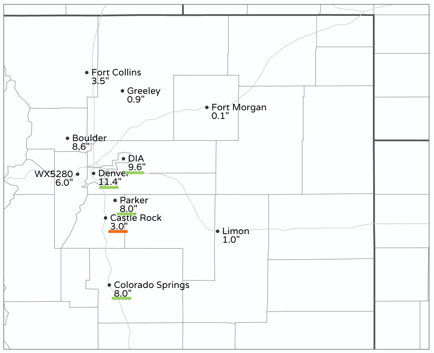
Denver officially recorded 9.6", the measurement taken at Denver International Airport this morning. That's no doubt a big bust (boom?) to our forecast, and the largest storm total so far for the city this season, and largest 2 day snowfall for the city (officially) since 2016.
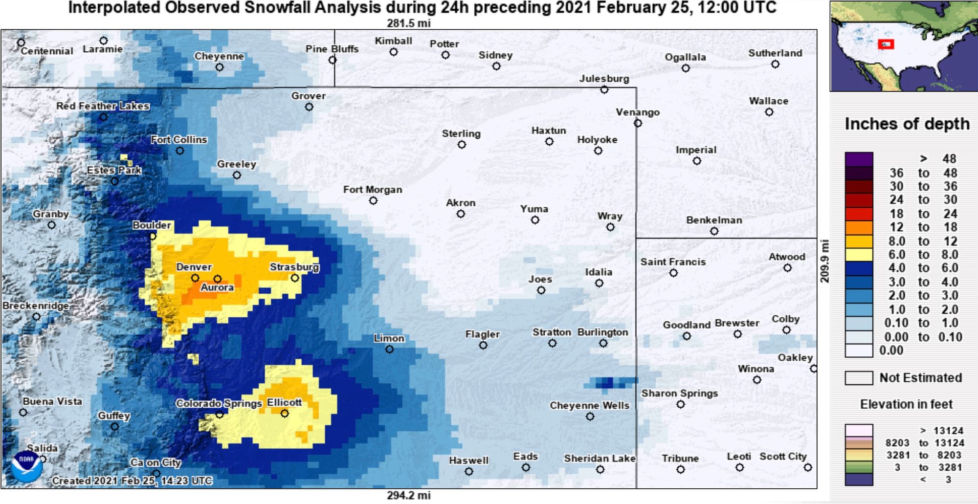
Of course, the city-center saw even more snow than this, with many reports this morning in the 10 - 12" range for Denver. Stapleton recorded 11.4" and is reflected in the map below.
The only real bust low in the cities highlighted below was Castle Rock. We had them in the 4 - 10" range, but most reports are coming in around 3.0" this morning (some parts of the city only saw 1 - 2" of snow). The totals underlined with green are boom totals, red busts, and no color means the total came in within range.

A look at interpolated snowfall totals from across the region shows this wasn't a classic upslope event burying the foothills, but instead the primary mechanisms that took over actually favored the inverse of what we often see. It's not often we end up with 6" on the west side of Denver and 10" at Denver International Airport! Good stuff. Also note the nice upslope totals south of the Palmer...
Outlook
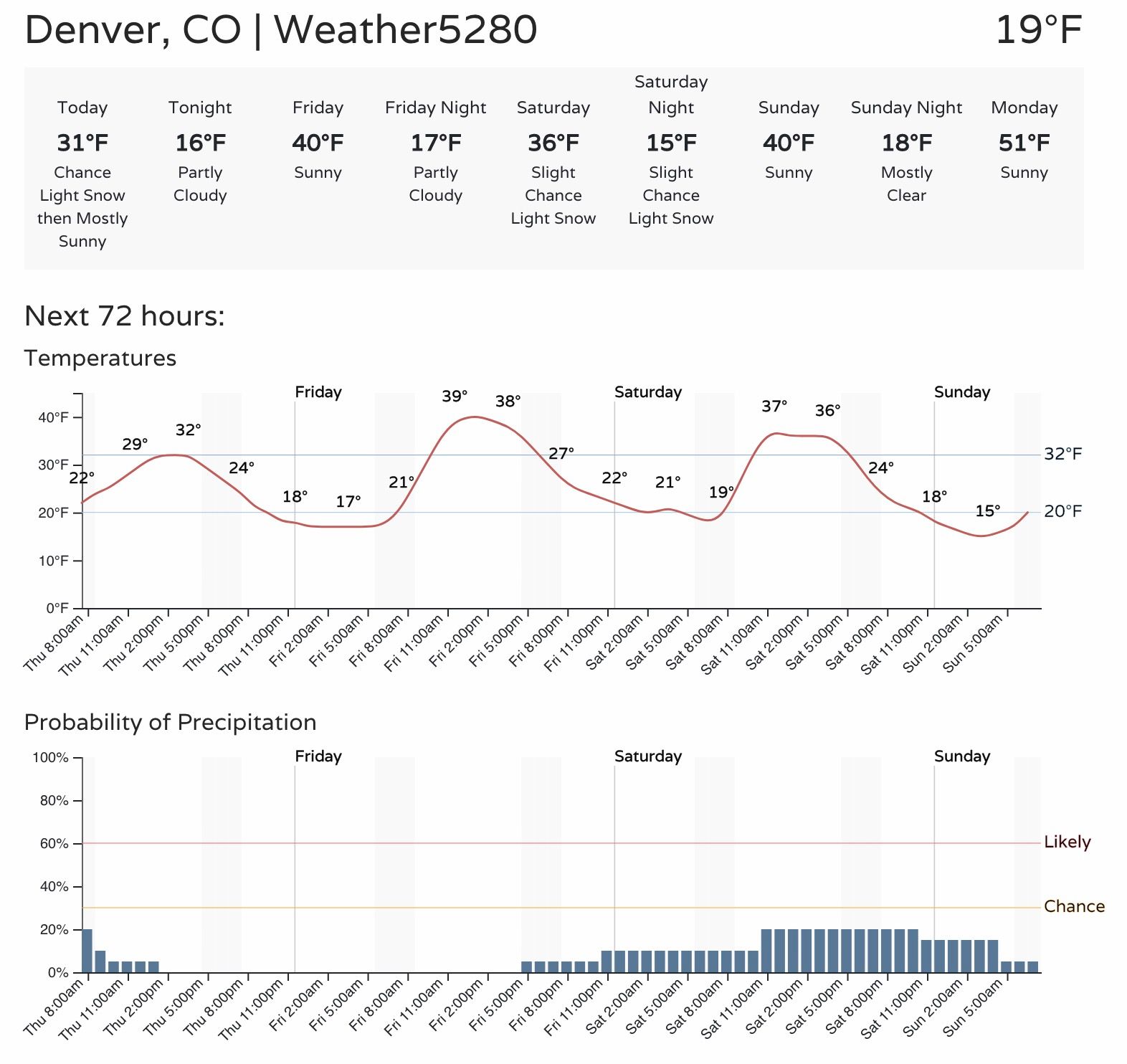
Temperatures will be near freezing today, but with that late February sun making an appearance at times it won't feel too bad today, and melting will already get underway in many locations.
Friday is a bit warmer before our next system swings through for the weekend. At the moment it looks like most of what snow the state sees will stay in the mountains, but we'll introduce a slight chance of snow at lower elevations by Friday night and keep an eye on things in case that changes.