
A significant snowstorm across Eastern Colorado is on the table for late week; plenty of uncertainty offers caution on going all-in

It's getting harder to ignore the signal for a significant storm to impact the region late this week and weekend. A slow moving system will move into the Southwest United States by mid week and eventually make its way toward Colorado by Friday and the weekend.
Increasing support for a significant event
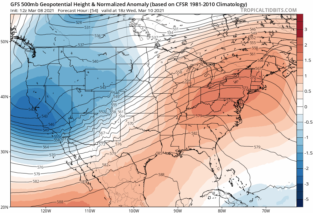
Overnight data came into better agreement with how models want to handle this large cutoff low as it moves through late this week. This trend we started to see on Sunday, and one that continued in the data overnight.
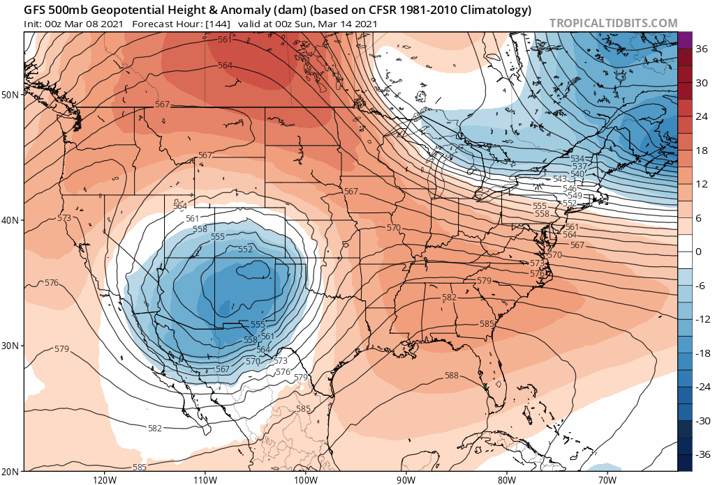
After jumping around quite a bit in earlier runs, the last three runs from the operational GFS has been more consistent in speed and placement of the low as it passes through the "sweet spot" for a heavy precipitation event late this week and weekend across much of Eastern Colorado. Here's a look at the last three runs for next Saturday evening, showing a large anomalous low tracking through Northern New Mexico before it eventually ejects and turns northeast late in the weekend.
This timing now better matches the European model. Some others still differ in timing, with the Canadian continuing to come in even slower with the evolution of the trough.
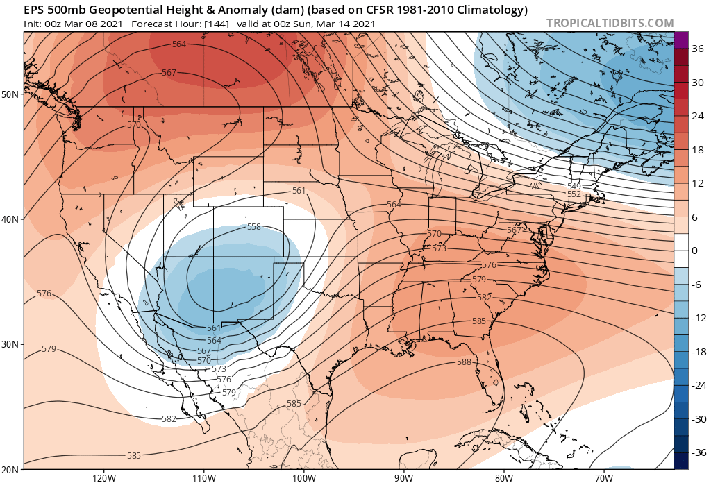
The European ensemble (meaning a blend of many different model runs with slightly different initialization tweaks) shows a broad cutoff low in a the similar location to the GFS Saturday evening. This looks better for snow along the Front Range than some of the earlier ensemble runs this weekend. Does this trend continue?
Bottomline: a cutoff low moving through the Four Corners in March needs to be watched. The upper level maps above indicate this system could take a favorable track (should things not change) to pull a lot of moisture into Eastern Colorado, and establish a deep upslope flow against the Rockies for an extended period of time – with the best chance coming in the Friday through Sunday timeframe at this time.
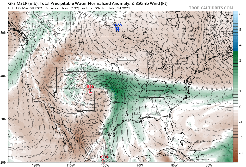
Here is a look at the GFS forecast for Saturday afternoon. The surface low tracking along the Colorado/New Mexico border, and precipitable water anomalies in excess of 1" across much of the eastern half of the state with easterly/northeasterly upslope flow in place:
Where uncertainty rules
If we look at a breakdown of one of the ensemble models we look at (in this case the GEFS) we can start to see there remains a lot of variation in possible solutions. Comparing two members in the image below (Northeast Colorado circled) show the divide that remains between the members – from near 0" for most areas in the p01, and upwards of 2 FEET for many folks in p06. If you look through the others you find a mix of all possible scenarios, but most showing a heavy snowfall event for the region.
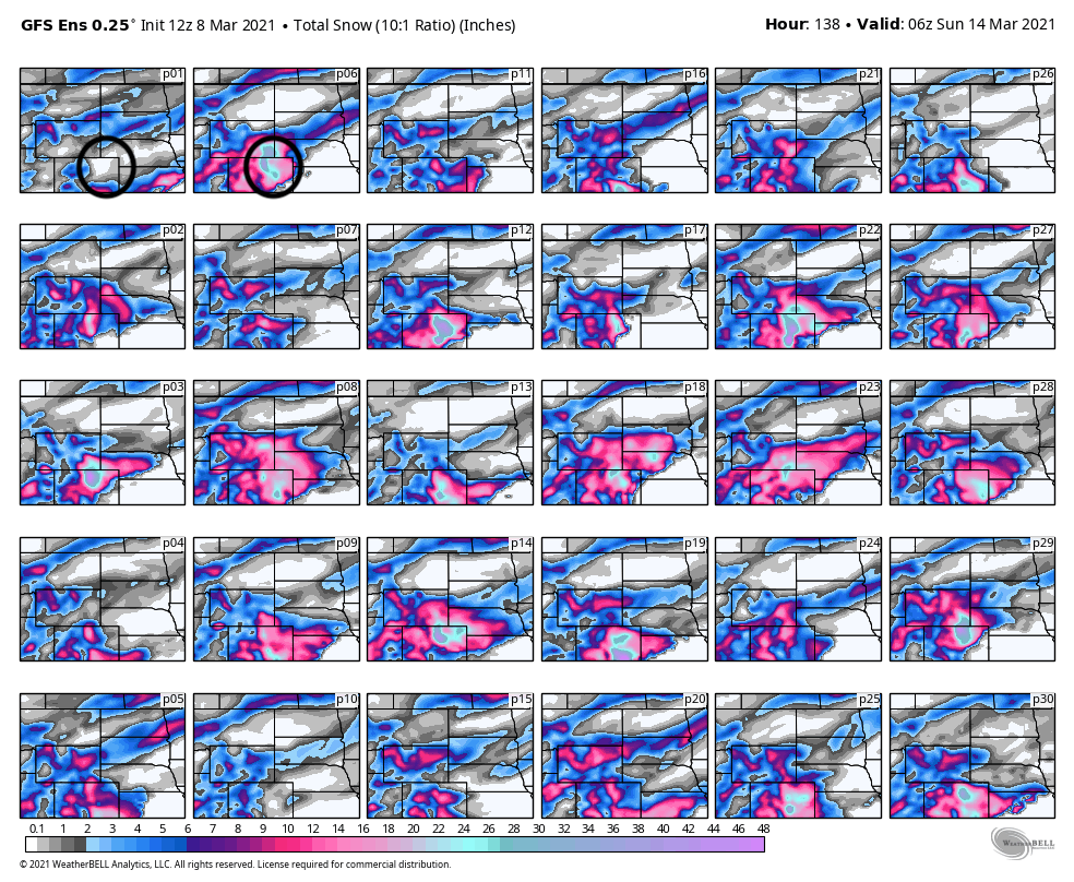
So, while we see the operational GFS modeled snowfall output this morning getting thrown around social media, there's still a lot of uncertainty in the data and this system remains several days out.
Another look at the spread in the precipitation forecast is below. The GEFS mean (GFS ensemble) has about 1.5" liquid for Denver through the weekend. By no means a non-event, but also nowhere near the 3 to 6" of liquid the operational model is outputting this morning. In fact, the wettest couple ensemble members are the only ones close to the operational output, with most showing notably less QPF. The takeaway here should be that there's still a HUGE amount of spread in the possible outcomes later this week, no matter how exciting any given operational model run may look.
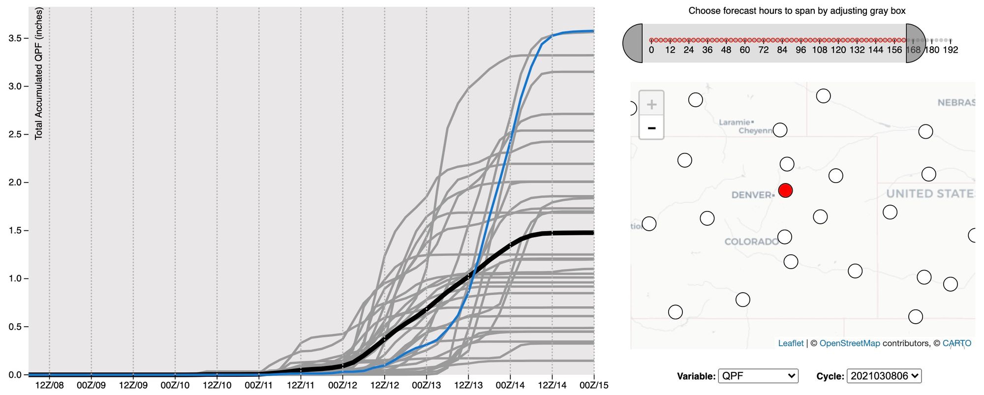
If we were to take the ensemble mean precipitation totals at their face value, we'd still be talking a significant storm on the way this weekend, but not historic by March standards as some models have been indicating.
The GEFS mean sits at about 1.5" for Denver, with the 12z European mean coming in about the same, showing 1.3" for the city. Both would indicate snowfall totals in excess of a foot will be possible IF things do not change between now and the weekend – and they will!
Probabilities
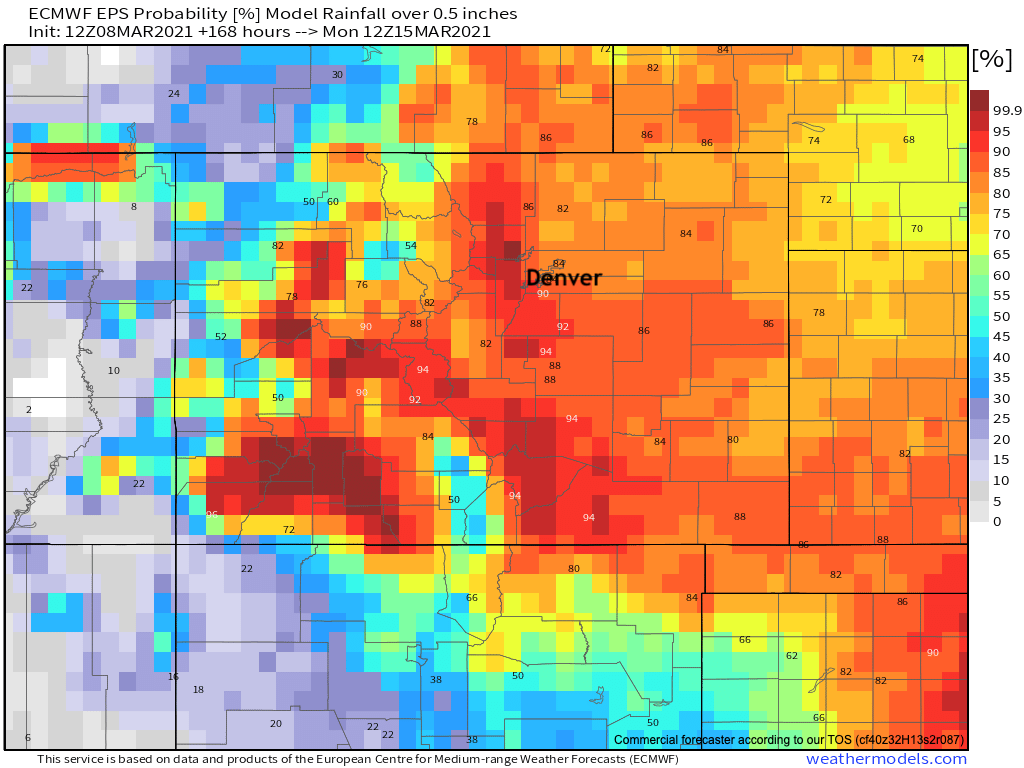
What are the odds we see significant precipitation this weekend? Well, they are up from yesterday, but still plenty of uncertainty with regard to the high-end potential at least.
For a half inch of precipitation or more (likely meaning 5" of snow or more) odds are from 70 to 90% across virtually all of eastern Colorado. The greatest odds are stacked against the Front Range foothills and I-25 corridor where upslope would prove most beneficial.
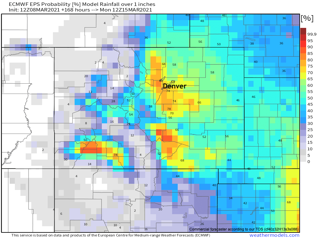
For the 1"+ totals we see in the means? Odds drop off, but are still not all that bad considering we're still four days out or so! From Colorado Springs through Denver those odds are sitting at about 60 to 75% at this time, with similar probabilities across the Palmer Divide. Lower probabilities as you head east.
Insiders, you can find our latest snowfall gambler charts here.
How to prepare
The first thing to do is make sure you are subscribed to Weather5280 to be sure you receive all the latest this week and there after. The next thing you need to do is unsubscribe from everyone sharing the 50" snowfall forecast map on social media today as a "maybe!". Yea, maybe, but that one would take the 2003 storm and make it look small – so let's keep perspective.
Still, there's potential for a significant event later this week, so do plan accordingly. Even if things do not align perfectly for a big event in your back yard, it's very likely that there will be significant travel impacts across the region from late Thursday night through Sunday unless this system comes onshore and decides to pave its own road elsewhere. This happens.
For now, keep an eye on the forecast and if you can take care of some items on your list before the weekend that would be a good idea. If things line up right, a Four Corners low in March and deliver a big time storm to the region, seasonal forecasts and La Niñas be damned!