It's about to get extremely cold, wind chills to drop to 50 below and colder behind arctic front
The cold air is on track and will arrive in Colorado Wednesday PM, plunging temperatures below zero across northern and eastern Colorado, with wind chill values approach -50°F or colder at times across the plains.
A Wind Chill Watch has been posted for the entire region beginning Wednesday evening and extending through Friday morning, here are some helpful tips for the cold from our friends at the National Weather Service in Boulder:
One of the worst cold snaps in 30 years will arrive behind a cold front Wednesday evening. Cover exposed skin to reduce your risk of frostbite or hypothermia! #COwx https://t.co/ZLURaIIlVl
— NWS Boulder (@NWSBoulder) December 20, 2022
We've received questions about travel and conditions across the country, so let's take a look at that as we go through Christmas Day here and in the attached video below. Let's not forget Alaska:
-62F temp just dropped. https://t.co/A6LZap3SZC
— Brian Brettschneider (@Climatologist49) December 20, 2022
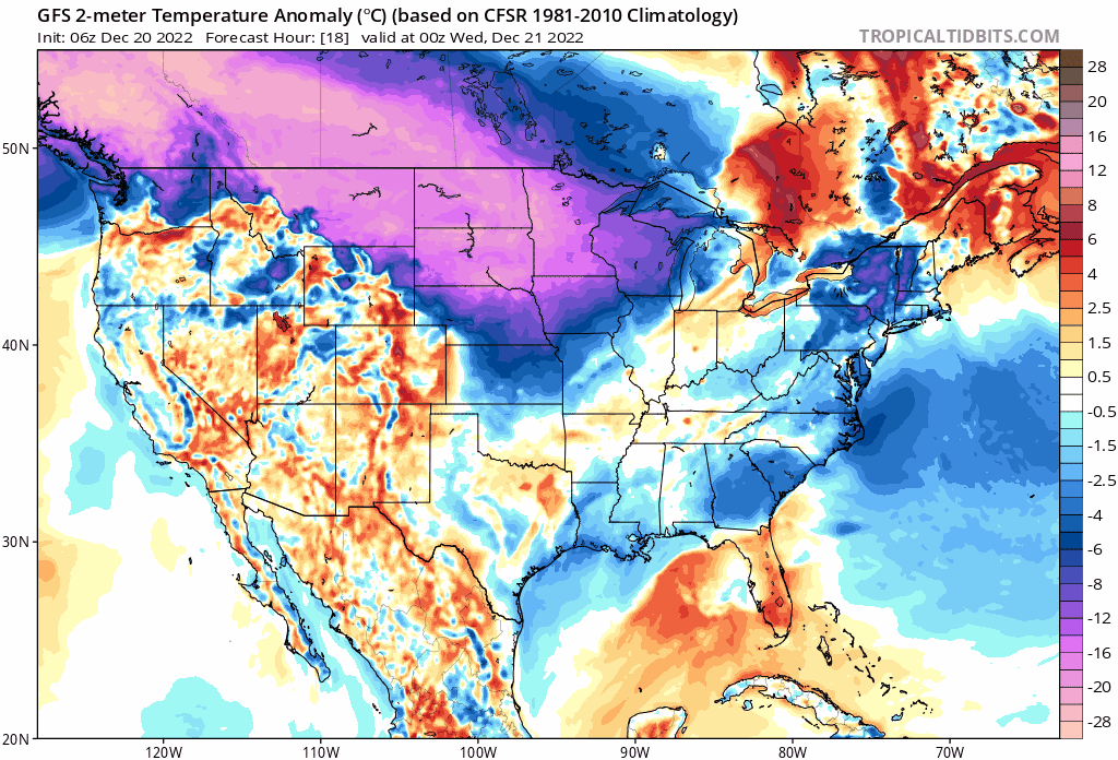
All that cold air is headed south.
The latest temperature anomaly forecast map from the GFS shows the dramatic invasion of cold air that will overwhelm the eastern two thirds of the country later this week:
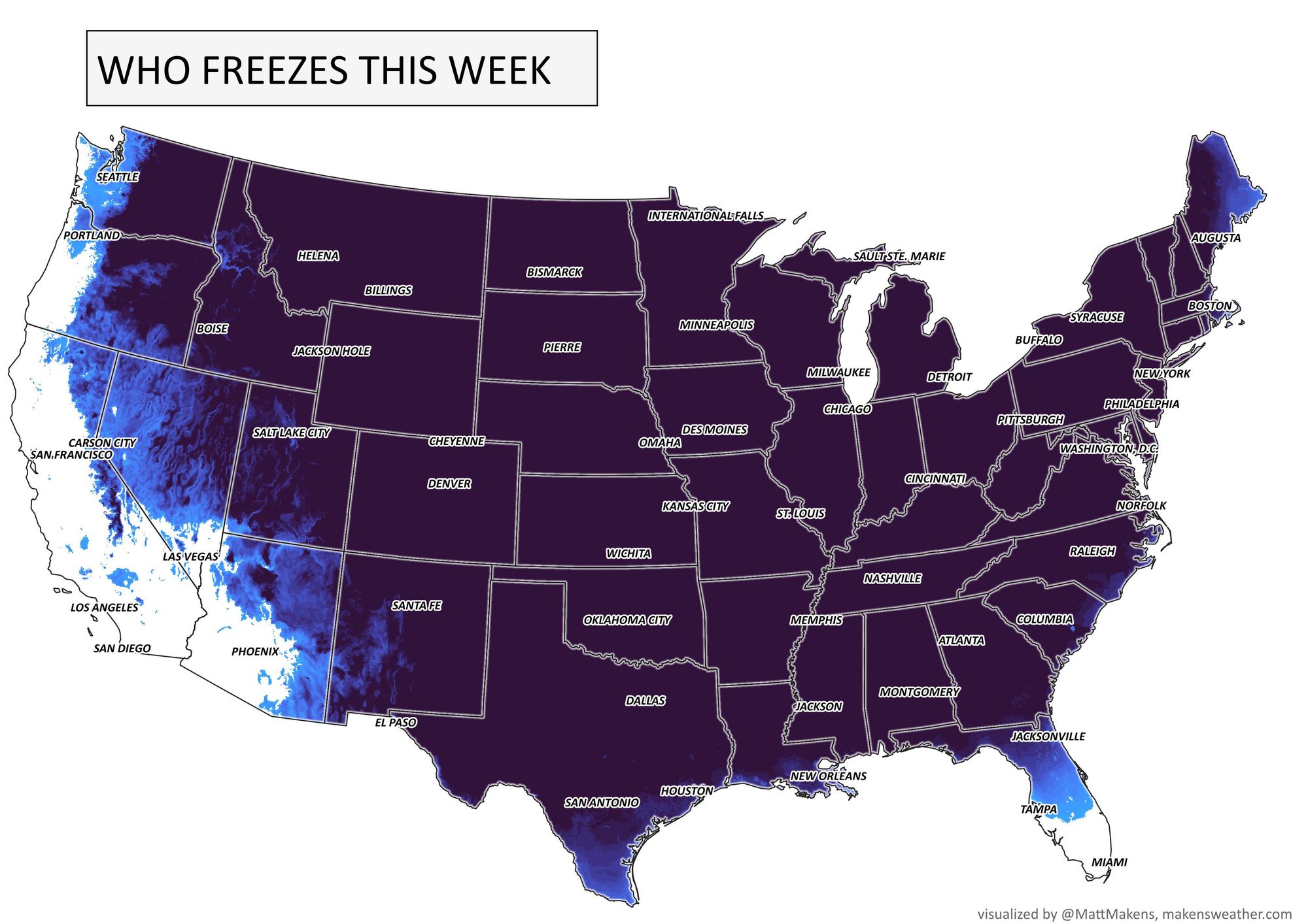
This map shows where frost and freezing conditions are likely this week, that's nearly the entire country!
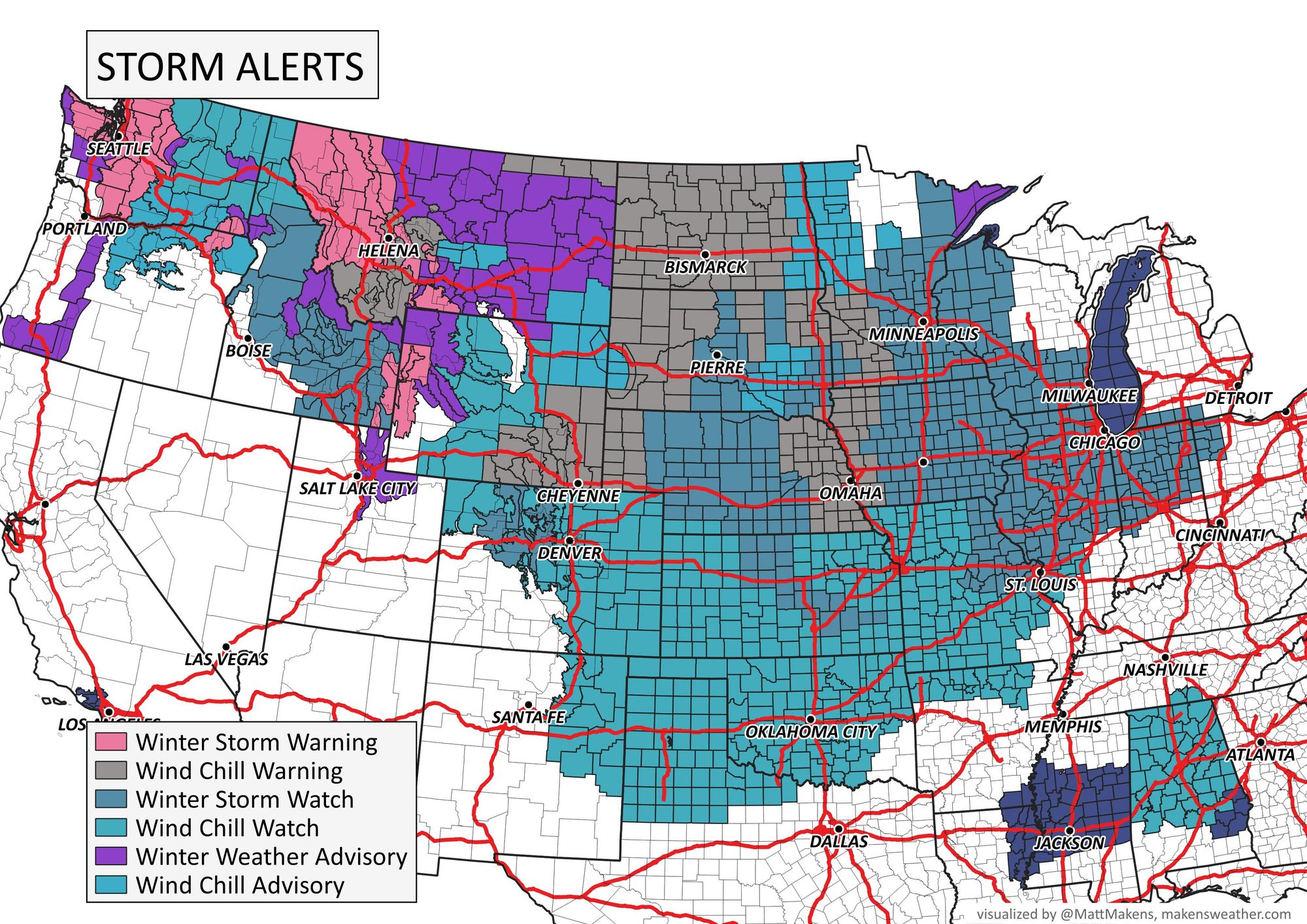
Digging in a bit deeper, the coldest of temperatures will be focusing in counties with these latest alerts as of Tuesday morning.

From the WPC's latest discussion:
The aforementioned repository of dangerous arctic air over the northern Plains and western Canada is expected to dump southward following behind the system crossing the Pacific Northwest today.
Subzero readings with minimum values nearing minus 20 and minus 30 degrees over the northern tier will enter into the northern Great Basin, northern Rockies, and much of the Great Plains by Thursday. Combined with wind gusts up to 60 mph, widespread wind chill values could drop to around minus 40 degrees throughout the central and north-central United States.
This level of cold can be life threatening and lead to frostbite on exposed skin in as little as 10 minutes. Wind Chill Warnings and Watches currently span across 17 states from Washington to Texas.
Here is the latest wind chill outlook for this week. Dangerous to life-threatening values as cold as 54 below are expected, especially Wednesday evening through Friday morning.#ndwx pic.twitter.com/wvey1z3akg
— NWS Bismarck (@NWSBismarck) December 19, 2022
And specific for the Denver area, the latest alert text from NWS Boulder includes a a rather remarkable statement: "as low as 55 below zero!":
...WIND CHILL WATCH REMAINS IN EFFECT FROM WEDNESDAY EVENING THROUGH FRIDAY MORNING...
* WHAT...Dangerously cold wind chills possible, as low as 55 below zero.
* WHERE...All of northeast and north central Colorado below 6000 feet, including the Denver metro area.
* WHEN...From Wednesday evening through Friday morning.
* IMPACTS...The dangerously cold wind chills could cause frostbite on exposed skin in as little as 5 minutes.
Wind chill values in this range would put us near record territory, and certainly on the list for some of the coldest on record:
Here's a look at the 10 lowest wind chills ever reported at KDEN (at Stapleton Airport 1974-1995, and DIA since then). The current NWS forecast for KDEN calls for wind chills down to -38 Thursday AM, which would be the 5th lowest on record there. Wow. #cowx pic.twitter.com/reCCWVvU6F
— Richard Romkee (@RRomkee) December 20, 2022
This video takes you through the impacts day by day through Christmas.
Tracking the cold
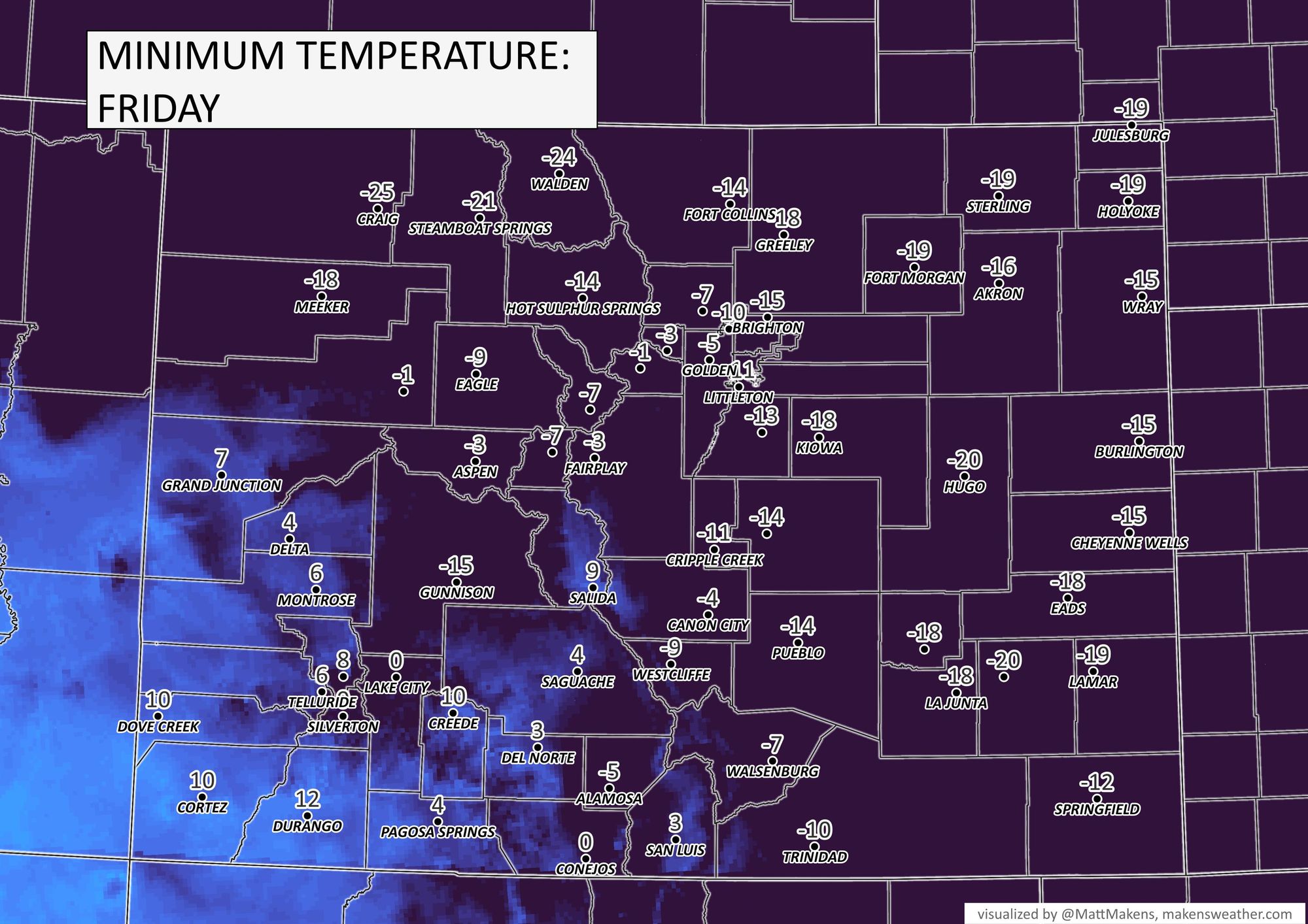
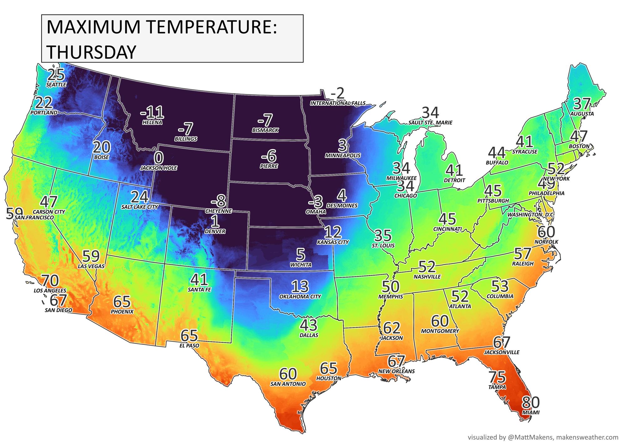
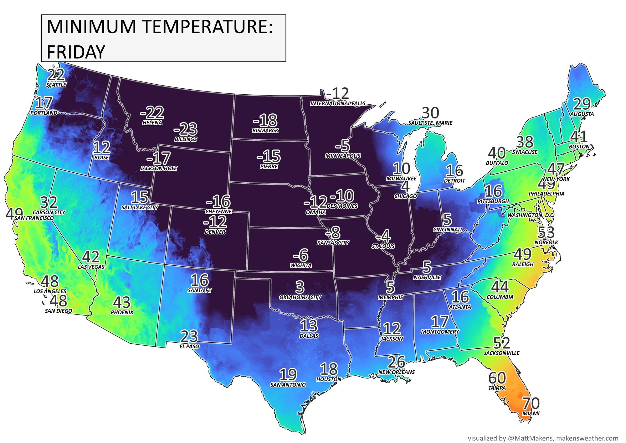
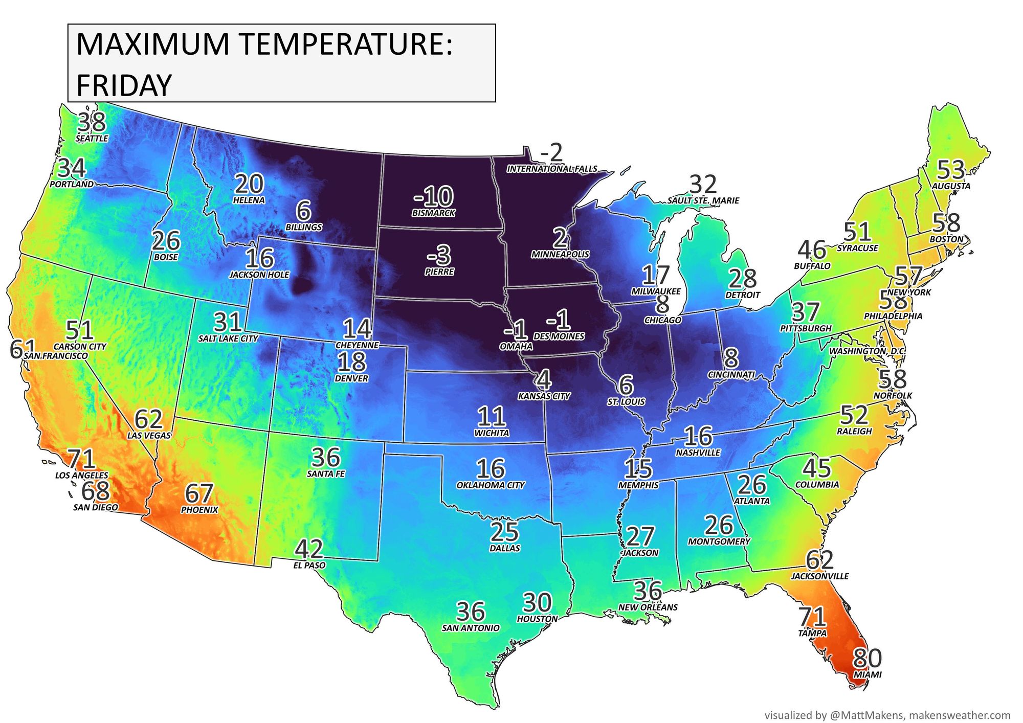
In the maps below we focus on the coldest moments for Colorado (being Thursday and Friday).
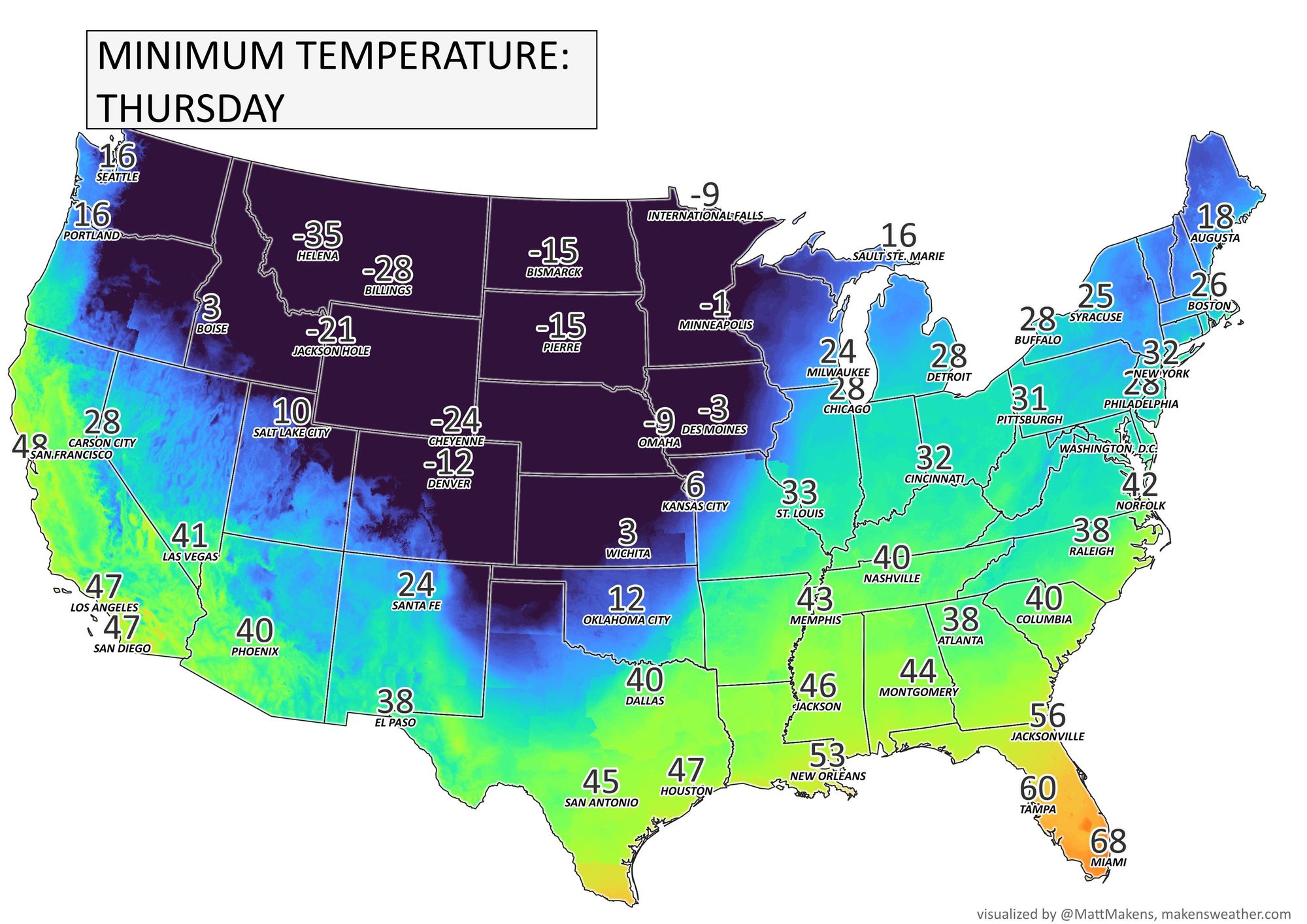
Here are Thursday's "high" temperatures
Friday's low temperatures
And then Friday's high temperatures, which rebound a bit for the west.
If you are curious how this compares to the 2021 event to our south, NWS Austin/San Antonio sums it up for Texas:
It will NOT be as cold as it got in Feb 2021, and we will NOT see any wintry precipitation this time around, however this level of cold temperatures only occur here on average about once every 10 years.
— NWS Austin/San Antonio (@NWSSanAntonio) December 19, 2022
For Colorado, this looks like it's likely to be one of the coldest outbreaks we have had in quite some time:
Thursday's high temp forecast is brutally cold! For Denver's official observing location at DIA, the forecast high is -5°.
— NWS Boulder (@NWSBoulder) December 19, 2022
- The last time Denver had a high below 0 was February 5, 2014
- The last time Denver had a high below the forecast of -5° was December 21, 1990 (-7°) #COwx pic.twitter.com/47RDCQb8Kl
The cold is forecast to arrive to northeast Colorado Wednesday afternoon and evening. Prior to the front's arrival, downsloping winds should push many of us along the urban corridor into the mid and upper 40s. Arctic fronts tend to always arrive quicker than advertised, but as of this writing it looks like the front initial will be pushing into Colorado shortly after noon on Wednesday, then through Denver between 4 and 7pm.
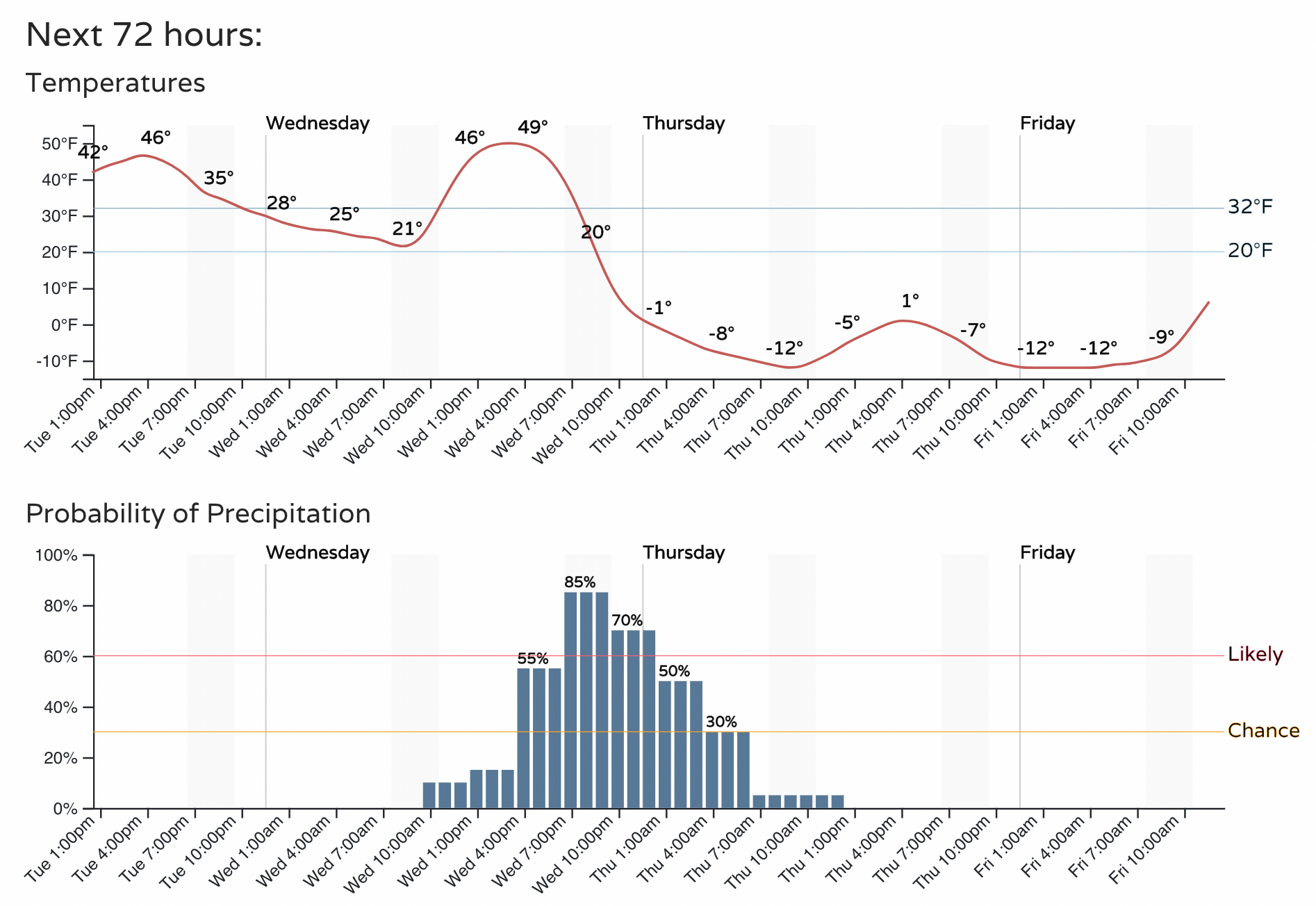
We'll expand on the snowfall forecast in our next update, but for the urban corridor it still looks like at least light snow accumulation is likely Wednesday evening and into Wednesday night behind the front. As the jet moves overhead Wednesday evening we expect pockets of heavier banded snowfall to develop, with several inches possible under these bands. Between the snow and cold, travel will not be advised Wednesday evening and overnight.
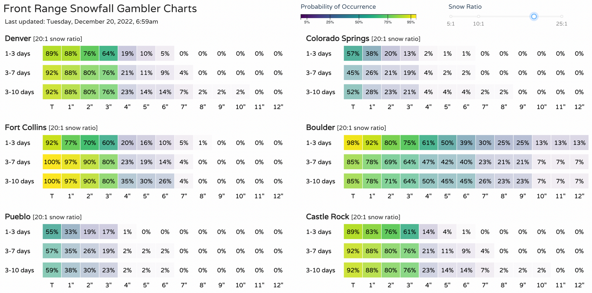
Here are our latest gamblers:
And our last update also discussing the snow potential: