Hurricane Hilary forecast to move inland over southern California as a tropical storm, bring years worth of rain with it

As we discussed yesterday, the desert southwest is making preparations for a rare event as hurricane Hilary (will be tropical storm Hilary) is set to move inland over the weekend and into next week bringing with it in some cases more rain over a three day period than many of these places will typically see over two years.
The sun rises on #Hurricane #Hilary pic.twitter.com/RGlPPXHgNQ
— Stu Ostro (@StuOstro) August 18, 2023
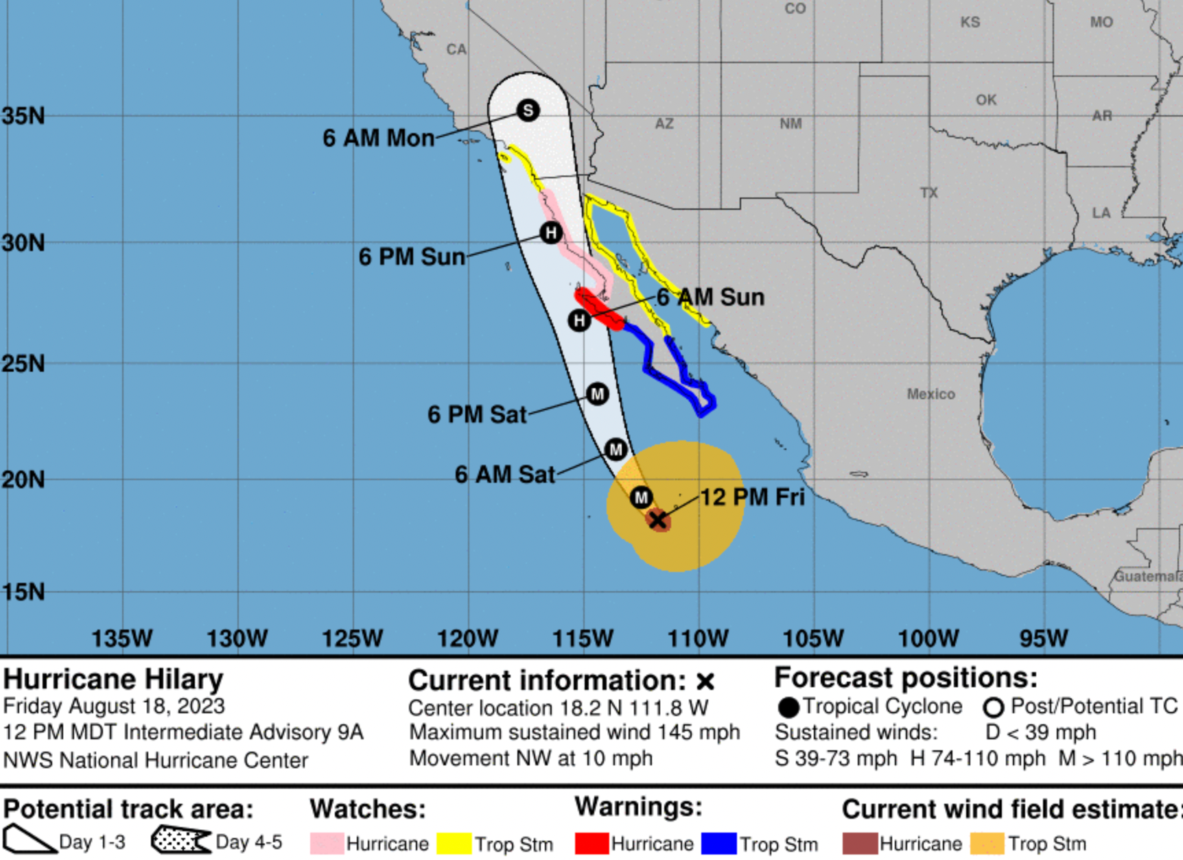
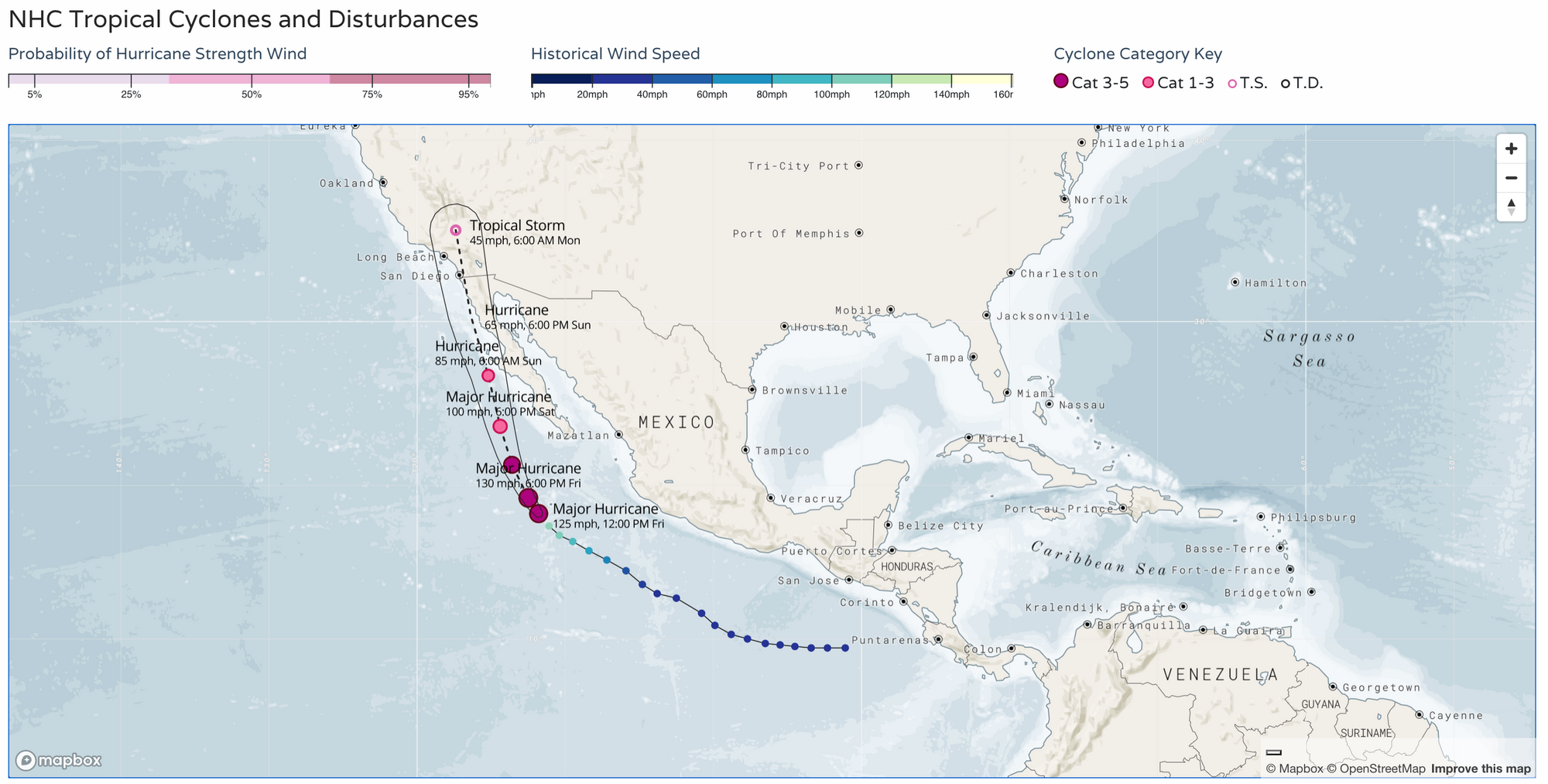
Here's the latest forecast track map, showing it moving into southern California Sunday night into Monday after weakening from a major hurricane today into a tropical storm. You can find an interactive version of this map here.
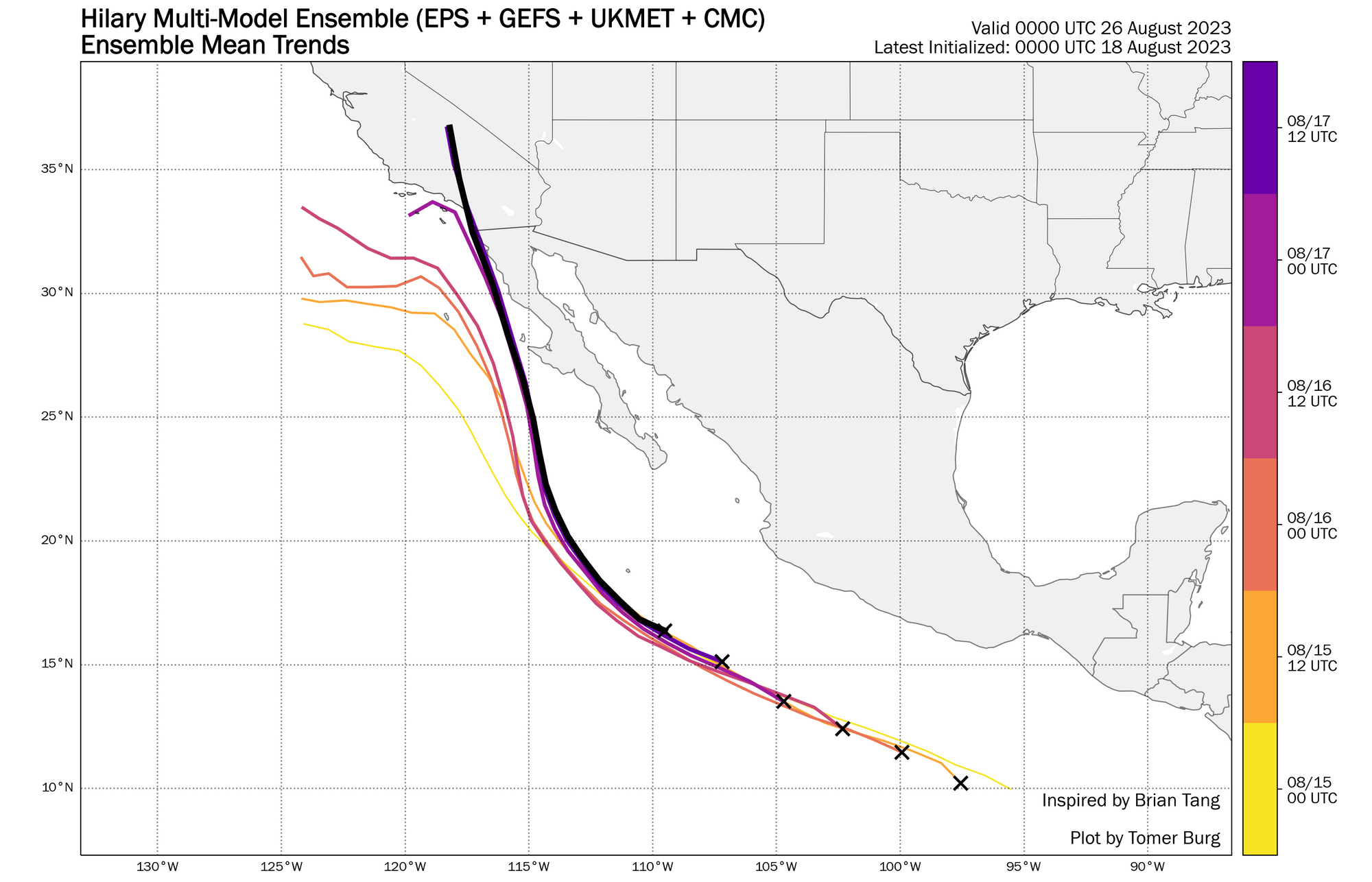
The westward trend has been pretty evident over the last couple of days, with good ensemble consensus now on the eventual track of Hilary as the storm moves north toward the U.S.:
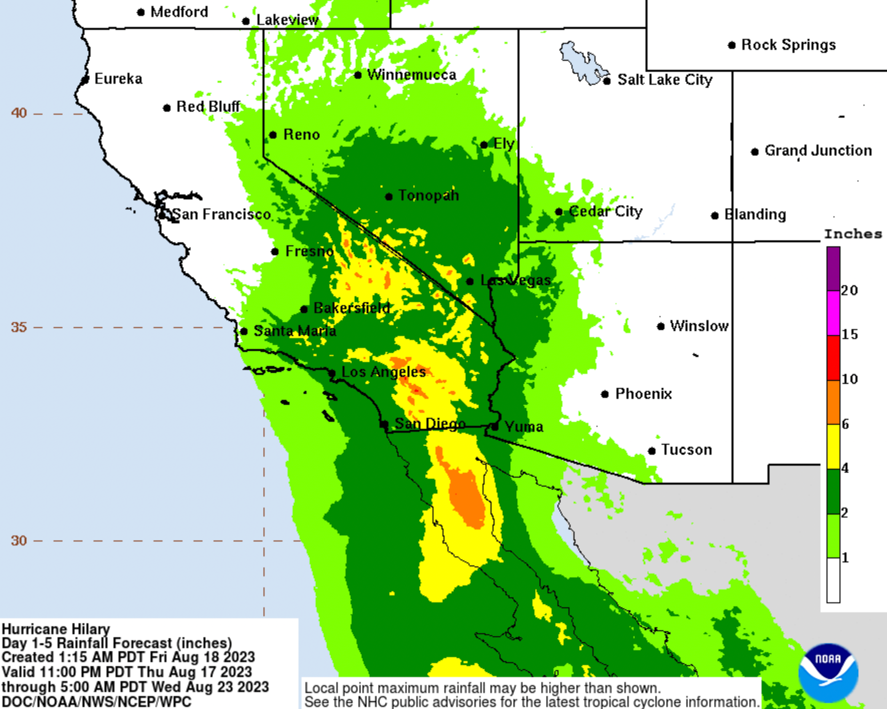
While wind and high surf will also be a factor, the amount of rain forecast for a part of the world ill equipped to deal with it will be the biggest story for most folks. Here's the latest flash flood guidance for the next 5 days via the WPC:
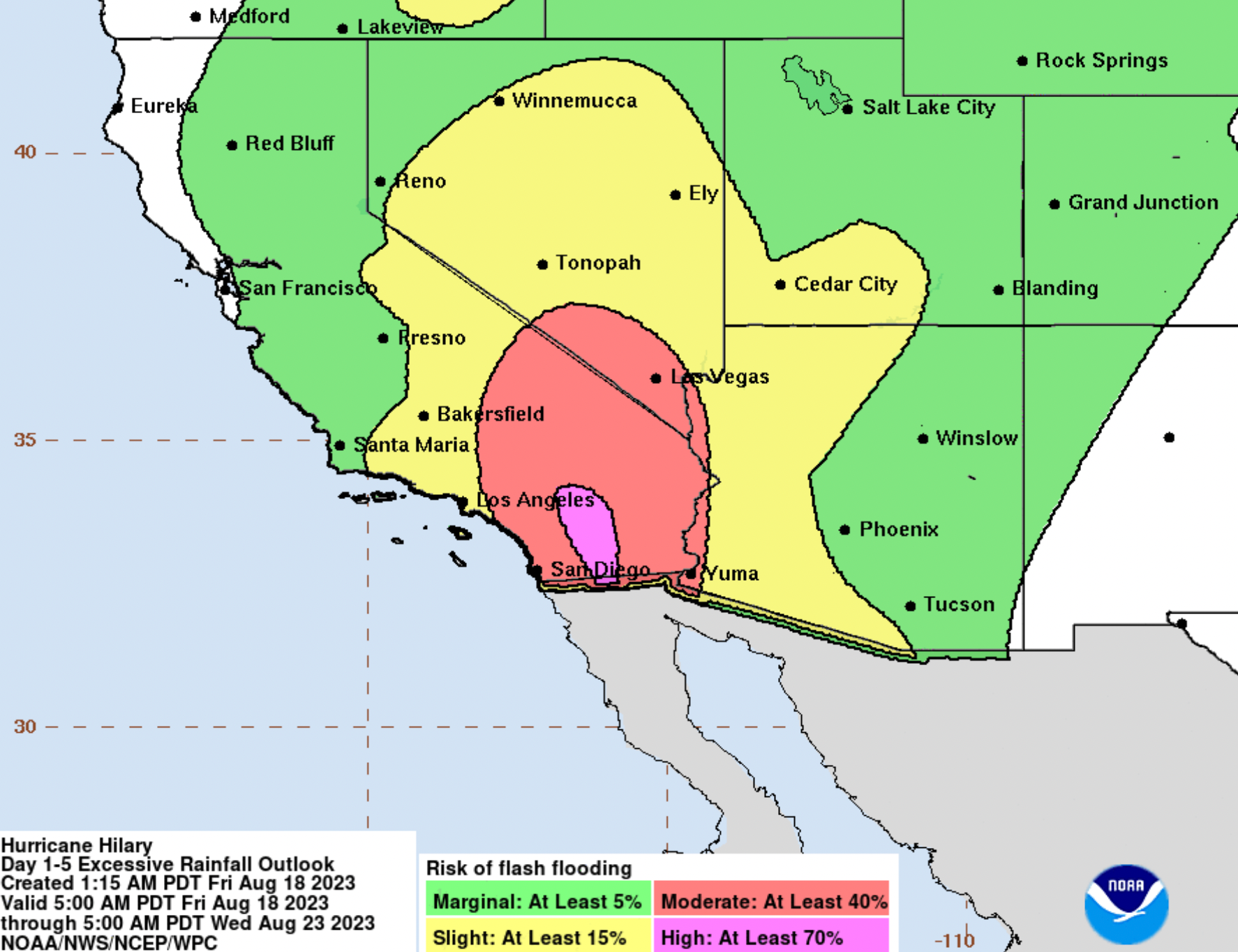
With much of Southern California and parts of Nevada expected to pick up 4 - 8" of rain from Hilary as the storm moves north over the next 5 days:
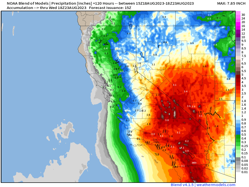
This closely matches the NBM precipitation outlook through Tuesday:
Needless to say, for places like Death Valley, California this isn't exactly your typical rainfall forecast. In fact, latest guidance suggests the area could see nearly double its previous 3-day record rainfall with this storm:
Update: the model estimate is now over 4" for a 3-day period. The record for the Park's climate station(s) is 1.88". The annual average is 2.2". Only 9 YEARS have had over 4" of total precipitation. https://t.co/LGyDdB8KXb pic.twitter.com/TKhi1WYJvz
— Brian Brettschneider (@Climatologist49) August 18, 2023
And that's not the only data point:
Model average + NWS forecast has 4" of rain in Imperial, CA over the next 3-4 days.
— Chris Bianchi (@BianchiWeather) August 18, 2023
That'd be more rain than Imperial's seen in the last 4 years combined (3.59"). #CAwx #Hilary pic.twitter.com/Q6Kb5kVKG8
Quick plot of 3-day @NWSWPC forecast rainfall from #Hilary ending 12Z 8/22 vs the avg ANNUAL rainfall. Areas in blue/purple/pink are forecast to receive more than their avg yearly rainfall in 3 days. https://t.co/NHArh9QKzF pic.twitter.com/KXmWg4BnpQ
— Tony (@whatdoweseehere) August 18, 2023
All that to say, flooding is going to be a huge concern over the coming days as the area braces for greatly anomalous rainfall from Hilary:
Flood risk from #Hilary in SE California deserts is genuinely alarming. Widespread & possibly destructive flash flooding is possible. This has high potential to be a historic flood event in this region. See attached screenshot of @NWSPhoenix forecast discussion from this AM.#CAwx https://t.co/zgj3tG3mr4 pic.twitter.com/Oj9881gJUP
— Dr. Daniel Swain (@Weather_West) August 18, 2023
Wild stuff.
Tropical Storm Watch issued
A Tropical Storm Watch is in effect for southern California now and is the first issuance of a TS Watch ever for the area.
Well, there it is: @NHC_Pacific has officially issued a Tropical Storm Watch for SoCal. This is the first such watch ever issued for West Coast of United States.
— Dr. Daniel Swain (@Weather_West) August 18, 2023
Wind will be a concern, but severe flood risk from very heavy rain will be the much greater threat. #CAwx #Hilary https://t.co/Az2ReagfSB
Here are some excerpts from the NWS watch:
* FLOODING RAIN: Prepare for life-threatening rainfall flooding having possible devastating impacts across Southern California. Potential impacts include:
- Extreme rainfall flooding may prompt numerous evacuations and rescues.
- Rivers and tributaries may overwhelmingly overflow their banks in many places with deep moving water. Small streams, creeks, canals, and ditches may become raging rivers. In mountain areas, deadly runoff may rage down valleys while increasing susceptibility to rockslides and mudslides. Flood control systems and barriers may become stressed.
- Flood waters can enter numerous structures within multiple communities, some structures becoming uninhabitable or washed away. Numerous places where flood waters may cover escape routes. Streets and parking lots become rivers of raging water with underpasses submerged. Driving conditions become very dangerous. Numerous road and bridge closures with some weakened or washed out.
* WIND: Prepare for dangerous wind having possible significant impacts across Southern California. Potential impacts in this area include:
- Some damage to roofing and siding materials, along with damage to porches, awnings, carports, and sheds. A few buildings experiencing window, door, and garage door failures. Mobile homes damaged, especially if unanchored. Unsecured lightweight objects become dangerous projectiles.
- Several large trees snapped or uprooted, but with greater numbers in places where trees are shallow rooted. Several fences and roadway signs blown over.
- Some roads impassable from large debris, and more within urban or heavily wooded places. Hazardous driving conditions on bridges and other elevated roadways.
- Scattered power and communications outages, but more prevalent in areas with above ground lines.
An impactful event on the way to be sure. If you live in the area or have plans to travel to the area please plan accordingly. As always, find the latest forecast updates, alerts, and guidance on the National Hurricane Center site: