
A brief pause of early March warmth on Thursday as much of Colorado will see rain, snow, and cooler temperatures with passing system

Our first March system is forecast to traverse the state Thursday and Thursday night as a cutoff low moves out of the Southwest and across southern Colorado.
As we discussed in this week's SOTA, this system will be lacking cold air, so how much snow we manage at lower elevations looks questionable at best. Those living across the Palmer Divide will have the best chance at seeing accumulating snow Thursday afternoon and evening where temperatures may cool just enough for some heavy wet snow for several hours on Thursday.
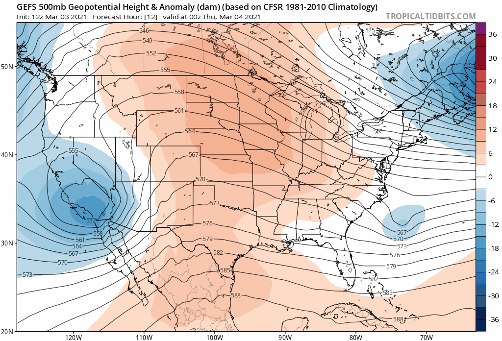
Here's a look at the system, moving into Southern California today, and across Colorado on Thursday. Note how quickly the ridge (reds) move back overhead behind the system's exit, indicating a quick return to very mild weather for Friday and the weekend across Eastern Colorado:
This system will be a very "spring" storm, in that elevation will play a larger role in who sees snow vs rain vs mix, and there's a good bet some of us hear some thunder Thursday afternoon under the heavier showers (both rain and snow) that develop across Eastern Colorado. Some of the first thunderstorms of the season are possible across the plains, low-topped storms but spring-like nonetheless.
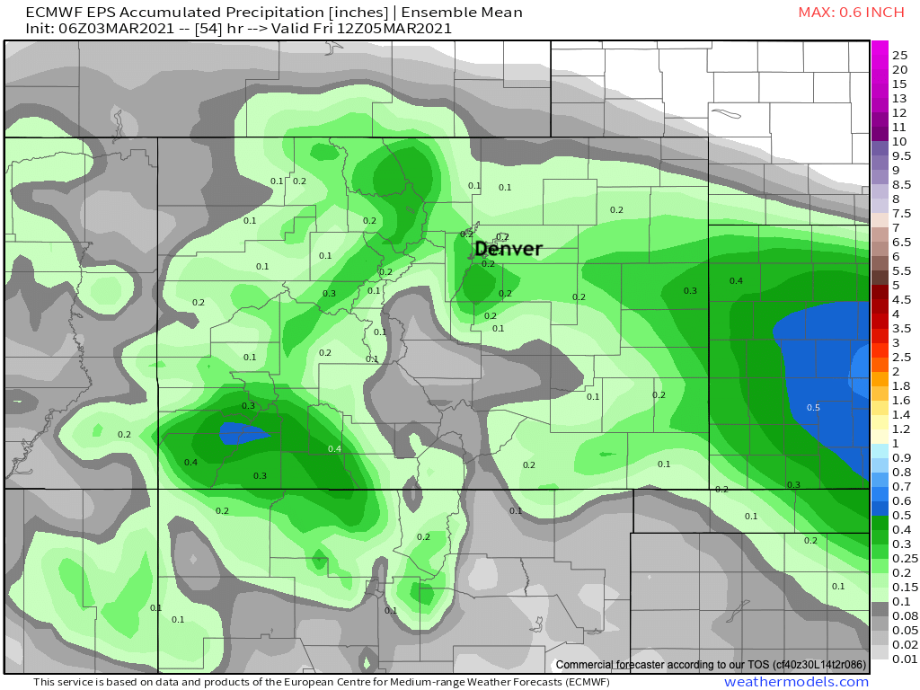
For the urban corridor, precipitation totals ranging from 0.1 - 0.3" are being forecast by the European ensemble mean, some of the high-resolution short term models are showing quite a bit more moisture than this, which seems possible under the heavier convective showers. The focus of the heaviest precipitation for our area should be between Denver and Colorado Springs, with favorable winds for the Palmer Divide, but a lack of upslope for the northern Front Range foothills as things look this morning meaning less snowfall and moisture potential unless the upslope is more substantial than data support at this time.
How much of that will fall in the form of snow, and accumulating snow at that is trickier.
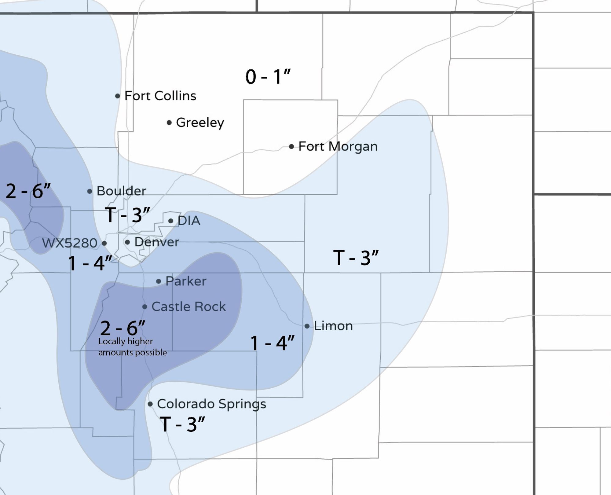
For the Palmer Divide, a couple of inches looks possible, even likely. We'll go with 2 - 6" here, with locally higher amounts. And, importantly, some very strong wind forecast here which could lead to some very tough travel conditions across the Divide Thursday afternoon and night. Speaking of travel, unlike previous systems this one is a lot warmer and road impacts may not be as severe as what we've seen to date.
To assess the overall threat of the storm we see lower threat despite this being a wet system...that's what we also mean by spring-like snowfall/accumulation.
For Denver and Colorado Springs we'll go with a Trace to 3". Greatest probabilities are for the Trace totals in this range, but some potential for a bit better cooling than anticipated and with that a few inches of heavy wet snow will be possible. Areas favored for this changeover will be outside of the city centers, so south Denver and northern Colorado Springs.
Here's our initial snowfall forecast for Thursday afternoon and night:
Some models are much more bullish on snow. The 3km NAM which did okay(?) with last week's storm, and the extended HRRR models are showing a widespread heavy snow event for the Palmer Divide, with several inches in the Denver metro as well. We think even if the heavier precipitation does materialize temperatures are going to be working against this solution in a bigger way than the NAM is indicating. Still, worth watching and see how things trend in the data tonight, and know some high-end potential is there even if not likely.
We do believe areas of heavy snowfall will struggle to accumulate an amount to match the snowfall rates due to how warm the system is. That's why our gamblers data around Denver show low potential snowfall depth accumulation versus snowfall rates we see in the models.
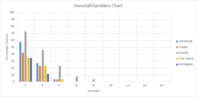
Link: Snowfall Gamblers Charts for the Front Range.
Again, what snow falls is not likely to equate to the same snow depth; It's been warm recently, ground temperatures are warming, higher sun angle now, too. So we enter the fun of spring snowfall versus snow depth forecasting.
With that considered, a low end T - 2" event or boom 3 - 6" event on the table tomorrow, with most totals looking to end up nicely within this range. The locally higher totals for the Palmer will cover a NAM/HRRR boom, we shall see.